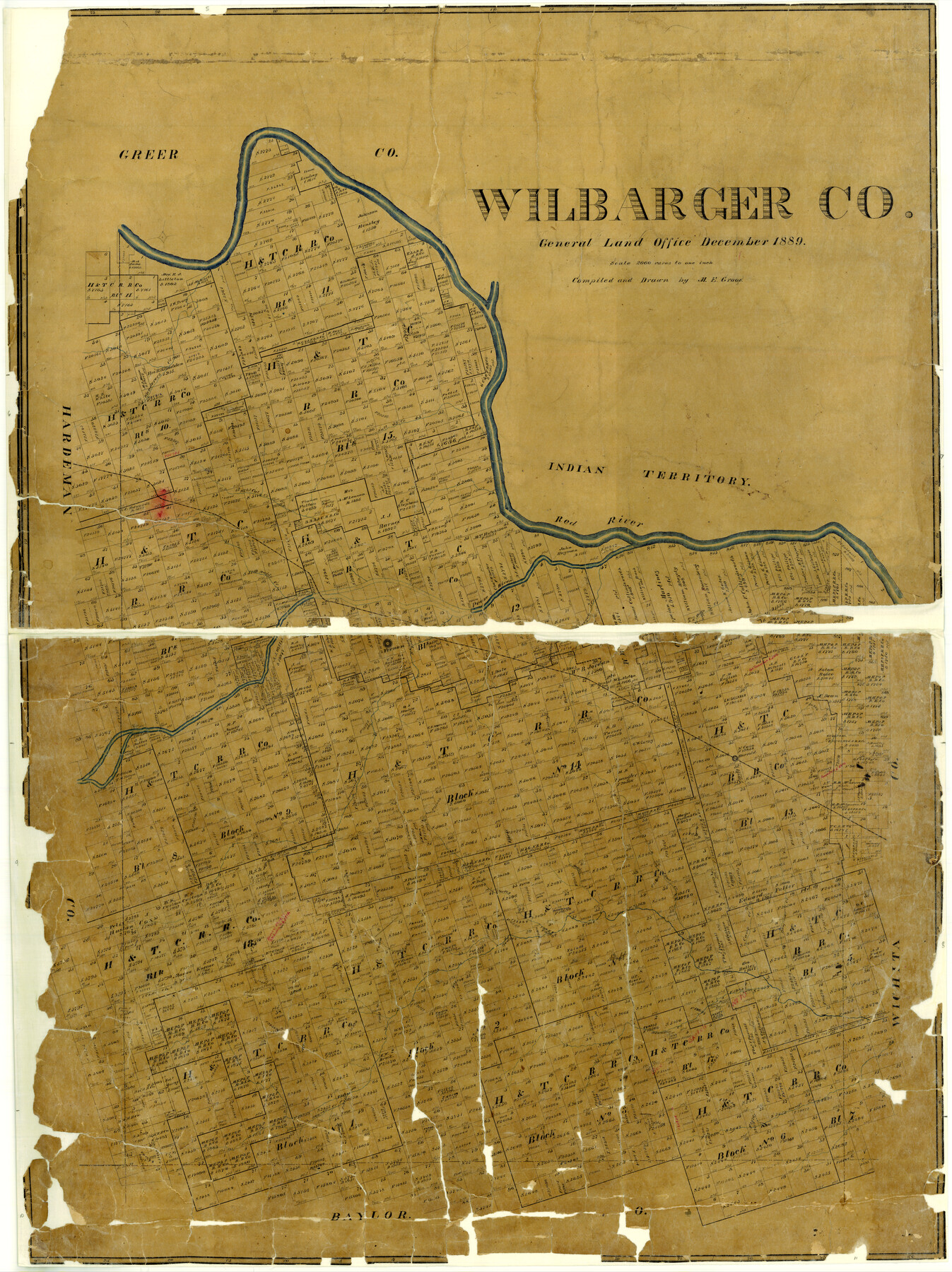
Wilbarger Co.
-
Map/Doc
4145
-
Collection
General Map Collection
-
Object Dates
1889 (Creation Date)
-
People and Organizations
Texas General Land Office (Publisher)
M.E. Groos (Draftsman)
M.E. Groos (Compiler)
-
Counties
Wilbarger
-
Subjects
County
-
Height x Width
50.0 x 37.4 inches
127.0 x 95.0 cm
-
Features
Paradise Creek
Long's Creek
South Beaver Creek
Minnas Creek
Beaver Creek
Camp Creek
Sunflower Creek
Rock Creek
Turkey Creek
China Creek
Harrold
Wanderers Creek
Man Creek
Vernon
Mores [sic] Creek
Dugan Creek
Pease River
Boggy Creek
Red River
Wild Cat Creek
Salt Creek
Mulberry Spring
Part of: General Map Collection
Val Verde County Working Sketch 70

Print $20.00
- Digital $50.00
Val Verde County Working Sketch 70
1966
Size 21.2 x 28.0 inches
Map/Doc 72205
[San Antonio & Aransas Pass R.R. Right of Way from Eagle Lake to Brazos River]
![64256, [San Antonio & Aransas Pass R.R. Right of Way from Eagle Lake to Brazos River], General Map Collection](https://historictexasmaps.com/wmedia_w700/maps/64256.tif.jpg)
Print $40.00
- Digital $50.00
[San Antonio & Aransas Pass R.R. Right of Way from Eagle Lake to Brazos River]
1895
Size 30.8 x 124.9 inches
Map/Doc 64256
Reagan County Working Sketch 8

Print $20.00
- Digital $50.00
Reagan County Working Sketch 8
1939
Size 37.8 x 23.3 inches
Map/Doc 71848
Mason County Sketch File 10

Print $6.00
- Digital $50.00
Mason County Sketch File 10
1885
Size 12.8 x 11.6 inches
Map/Doc 30693
Duval County Rolled Sketch 46

Print $20.00
- Digital $50.00
Duval County Rolled Sketch 46
1985
Size 24.9 x 36.1 inches
Map/Doc 5761
Maps of Gulf Intracoastal Waterway, Texas - Sabine River to the Rio Grande and connecting waterways including ship channels

Print $20.00
- Digital $50.00
Maps of Gulf Intracoastal Waterway, Texas - Sabine River to the Rio Grande and connecting waterways including ship channels
1966
Size 14.6 x 22.2 inches
Map/Doc 61955
Northwest Part Pecos County

Print $20.00
- Digital $50.00
Northwest Part Pecos County
1975
Size 42.2 x 42.2 inches
Map/Doc 77395
Right of Way and Track Map, the Missouri, Kansas and Texas Ry. of Texas - Henrietta Division

Print $20.00
- Digital $50.00
Right of Way and Track Map, the Missouri, Kansas and Texas Ry. of Texas - Henrietta Division
1918
Size 11.8 x 26.8 inches
Map/Doc 64752
San Saba County Sketch File 14b

Print $8.00
- Digital $50.00
San Saba County Sketch File 14b
1899
Size 14.3 x 8.9 inches
Map/Doc 36448
Culberson County Working Sketch 21

Print $40.00
- Digital $50.00
Culberson County Working Sketch 21
1936
Size 36.7 x 57.8 inches
Map/Doc 68473
Flight Mission No. BRA-16M, Frame 59, Jefferson County

Print $20.00
- Digital $50.00
Flight Mission No. BRA-16M, Frame 59, Jefferson County
1953
Size 18.3 x 22.5 inches
Map/Doc 85676
Map of Chicago, Rock Island & Texas Railway through Tarrant County, Texas

Print $20.00
- Digital $50.00
Map of Chicago, Rock Island & Texas Railway through Tarrant County, Texas
1893
Size 20.7 x 35.7 inches
Map/Doc 64414
You may also like
Pecos County Rolled Sketch 90

Print $20.00
- Digital $50.00
Pecos County Rolled Sketch 90
1934
Size 26.7 x 33.9 inches
Map/Doc 7245
Presidio County Rolled Sketch 84

Print $20.00
- Digital $50.00
Presidio County Rolled Sketch 84
1942
Size 22.7 x 33.1 inches
Map/Doc 9779
Gillespie County Working Sketch 2

Print $20.00
- Digital $50.00
Gillespie County Working Sketch 2
1958
Size 35.9 x 26.0 inches
Map/Doc 63165
Webb County Sketch File 50-1

Print $8.00
- Digital $50.00
Webb County Sketch File 50-1
1943
Size 14.5 x 8.9 inches
Map/Doc 39833

Reagan County Rolled Sketch 40

Print $40.00
- Digital $50.00
Reagan County Rolled Sketch 40
Size 90.0 x 39.3 inches
Map/Doc 9831
Dawson County

Print $20.00
- Digital $50.00
Dawson County
1959
Size 43.5 x 35.1 inches
Map/Doc 77259
Right of Way and Track Map, International & Gt. Northern Ry. operated by the International & Gt. Northern Ry. Co. Gulf Division, Mineola Branch

Print $40.00
- Digital $50.00
Right of Way and Track Map, International & Gt. Northern Ry. operated by the International & Gt. Northern Ry. Co. Gulf Division, Mineola Branch
1917
Size 25.2 x 120.8 inches
Map/Doc 64703
Calcasieu Pass to Sabine Pass

Print $20.00
- Digital $50.00
Calcasieu Pass to Sabine Pass
1946
Size 45.0 x 35.7 inches
Map/Doc 69807
Nueces County Rolled Sketch 49

Print $20.00
- Digital $50.00
Nueces County Rolled Sketch 49
1941
Size 34.9 x 28.8 inches
Map/Doc 6889
Galveston County Sketch File 2

Print $2.00
- Digital $50.00
Galveston County Sketch File 2
1845
Size 8.3 x 11.1 inches
Map/Doc 23349
Gaines County, Texas

Print $40.00
- Digital $50.00
Gaines County, Texas
Size 60.0 x 31.3 inches
Map/Doc 89684