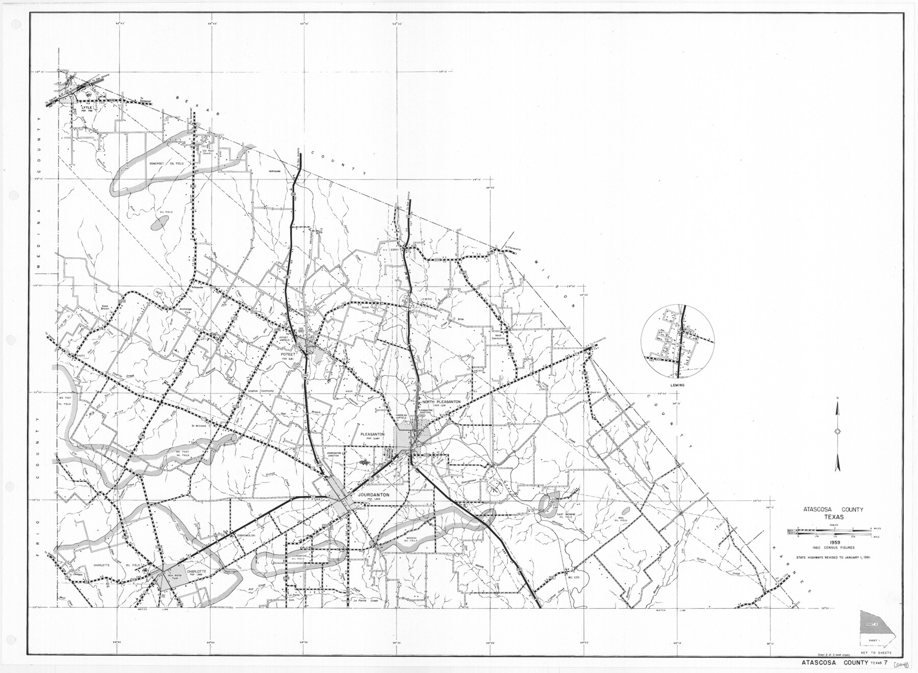
General Highway Map, Atascosa County, Texas
-
Map/Doc
79356
-
Collection
Texas State Library and Archives
-
Object Dates
1961 (Creation Date)
-
People and Organizations
Texas State Highway Department (Publisher)
-
Counties
Atascosa
-
Subjects
County
-
Height x Width
18.3 x 24.9 inches
46.5 x 63.3 cm
-
Comments
Prints available courtesy of the Texas State Library and Archives.
More info can be found here: TSLAC Map 05041
Part of: Texas State Library and Archives
General Highway Map, Upton County, Texas

Print $20.00
General Highway Map, Upton County, Texas
1940
Size 24.8 x 18.1 inches
Map/Doc 79265
General Highway Map. Detail of Cities and Towns in Dallas County, Texas [Dallas and vicinity]
![79070, General Highway Map. Detail of Cities and Towns in Dallas County, Texas [Dallas and vicinity], Texas State Library and Archives](https://historictexasmaps.com/wmedia_w700/maps/79070.tif.jpg)
Print $20.00
General Highway Map. Detail of Cities and Towns in Dallas County, Texas [Dallas and vicinity]
1936
Size 18.4 x 25.1 inches
Map/Doc 79070
General Highway Map, Hays County, Texas

Print $20.00
General Highway Map, Hays County, Texas
1961
Size 18.1 x 24.7 inches
Map/Doc 79513
General Highway Map, Stephens County, Texas

Print $20.00
General Highway Map, Stephens County, Texas
1940
Size 24.9 x 18.3 inches
Map/Doc 79247
General Highway Map, Tom Green County, Texas

Print $20.00
General Highway Map, Tom Green County, Texas
1940
Size 25.0 x 18.5 inches
Map/Doc 79260
General Highway Map, Orange County, Texas

Print $20.00
General Highway Map, Orange County, Texas
1961
Size 18.1 x 24.5 inches
Map/Doc 79621
Map of Texas Compiled from surveys recorded in the General Land Office

Print $20.00
Map of Texas Compiled from surveys recorded in the General Land Office
1851
Size 31.4 x 25.3 inches
Map/Doc 76209
General Highway Map. Detail of Cities and Towns in Travis County, Texas

Print $20.00
General Highway Map. Detail of Cities and Towns in Travis County, Texas
1961
Size 18.1 x 24.7 inches
Map/Doc 79683
Post Route Map of the State of Texas with Adjacent Parts of Louisiana, Arkansas, Indian Territory and the Republic of Mexico Showing Post Offices with the Intermediate Distances and Mail Routes in Operation on the 1st of April 1891

Print $40.00
Post Route Map of the State of Texas with Adjacent Parts of Louisiana, Arkansas, Indian Territory and the Republic of Mexico Showing Post Offices with the Intermediate Distances and Mail Routes in Operation on the 1st of April 1891
1891
Size 44.5 x 58.2 inches
Map/Doc 89061
General Highway Map. Detail of Cities and Towns in Tyler County, Texas [Woodville and vicinity]
![79691, General Highway Map. Detail of Cities and Towns in Tyler County, Texas [Woodville and vicinity], Texas State Library and Archives](https://historictexasmaps.com/wmedia_w700/maps/79691.tif.jpg)
Print $20.00
General Highway Map. Detail of Cities and Towns in Tyler County, Texas [Woodville and vicinity]
1961
Size 18.1 x 24.8 inches
Map/Doc 79691
General Highway Map, Tyler County, Texas

Print $20.00
General Highway Map, Tyler County, Texas
1961
Size 24.8 x 18.1 inches
Map/Doc 79690
General Highway Map, Hays County, Texas

Print $20.00
General Highway Map, Hays County, Texas
1940
Size 24.8 x 18.3 inches
Map/Doc 79123
You may also like
Frio County Working Sketch 27

Print $20.00
- Digital $50.00
Frio County Working Sketch 27
Size 25.3 x 36.8 inches
Map/Doc 78193
Hardin County Working Sketch 25

Print $20.00
- Digital $50.00
Hardin County Working Sketch 25
1950
Size 10.8 x 20.1 inches
Map/Doc 63423
Shackelford County Boundary File 4

Print $2.00
- Digital $50.00
Shackelford County Boundary File 4
Size 6.6 x 8.8 inches
Map/Doc 58660
Map of the southern states, including rail roads, county towns, state capitals, county roads, the southern coast from Delaware to Texas, showing the harbors, inlets, forts and position of blockading ships

Print $20.00
- Digital $50.00
Map of the southern states, including rail roads, county towns, state capitals, county roads, the southern coast from Delaware to Texas, showing the harbors, inlets, forts and position of blockading ships
1863
Size 22.1 x 32.3 inches
Map/Doc 96635
Flight Mission No. DAG-24K, Frame 130, Matagorda County

Print $20.00
- Digital $50.00
Flight Mission No. DAG-24K, Frame 130, Matagorda County
1953
Size 17.1 x 18.8 inches
Map/Doc 86548
Map of Blanco County, Texas

Print $20.00
- Digital $50.00
Map of Blanco County, Texas
1880
Size 28.5 x 20.1 inches
Map/Doc 406
Burleson County Working Sketch 22

Print $20.00
- Digital $50.00
Burleson County Working Sketch 22
1980
Size 14.6 x 15.6 inches
Map/Doc 67741
Floyd County Sketch File 13

Print $36.00
- Digital $50.00
Floyd County Sketch File 13
1913
Size 11.4 x 9.0 inches
Map/Doc 22713
Wichita County Sketch File 14

Print $20.00
- Digital $50.00
Wichita County Sketch File 14
1885
Size 17.7 x 17.0 inches
Map/Doc 12678
Brown County Sketch File 8

Print $4.00
- Digital $50.00
Brown County Sketch File 8
1860
Size 13.4 x 8.1 inches
Map/Doc 16593
Boundary and Ownership map, Laguna Atascosa National Wildlife Refuge, Cameron and Willacy Counties, Texas

Print $40.00
- Digital $50.00
Boundary and Ownership map, Laguna Atascosa National Wildlife Refuge, Cameron and Willacy Counties, Texas
1968
Size 73.1 x 43.0 inches
Map/Doc 60394
The Republic County of Harrison. June 24, 1841

Print $20.00
The Republic County of Harrison. June 24, 1841
2020
Size 18.6 x 21.7 inches
Map/Doc 96171