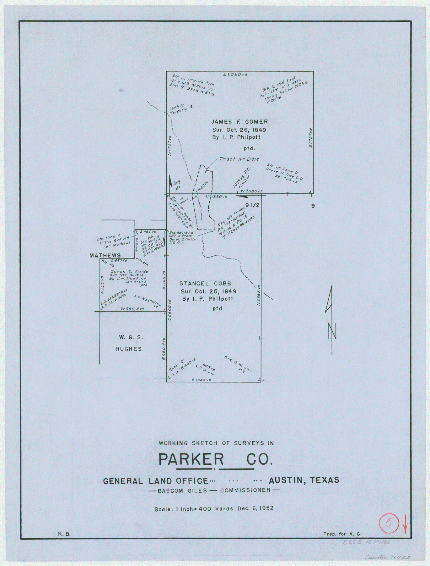
Parker County Working Sketch 5
-
Map/Doc
71455
-
Collection
General Map Collection
-
Object Dates
12/6/1952 (Creation Date)
-
People and Organizations
Roy Buckholts (Draftsman)
-
Counties
Parker
-
Subjects
Surveying Working Sketch
-
Scale
1" = 400 varas
Part of: General Map Collection
Starr County Boundary File 2

Print $8.00
- Digital $50.00
Starr County Boundary File 2
Size 11.0 x 7.4 inches
Map/Doc 58814
Hardin County Sketch File 7

Print $6.00
- Digital $50.00
Hardin County Sketch File 7
Size 7.2 x 5.9 inches
Map/Doc 25099
[Surveys near Brushy Creek]
![360, [Surveys near Brushy Creek], General Map Collection](https://historictexasmaps.com/wmedia_w700/maps/360.tif.jpg)
Print $2.00
- Digital $50.00
[Surveys near Brushy Creek]
1845
Size 10.0 x 7.9 inches
Map/Doc 360
Map of Anderson County

Print $20.00
- Digital $50.00
Map of Anderson County
1876
Size 19.4 x 21.9 inches
Map/Doc 3228
Flight Mission No. DAG-23K, Frame 180, Matagorda County

Print $20.00
- Digital $50.00
Flight Mission No. DAG-23K, Frame 180, Matagorda County
1953
Size 18.4 x 16.0 inches
Map/Doc 86515
Flight Mission No. BQR-22K, Frame 34, Brazoria County

Print $20.00
- Digital $50.00
Flight Mission No. BQR-22K, Frame 34, Brazoria County
1953
Size 18.7 x 22.5 inches
Map/Doc 84118

Plan of the City of Austin

Print $40.00
- Digital $50.00
Plan of the City of Austin
1840
Size 57.3 x 42.0 inches
Map/Doc 2179
Flight Mission No. CRE-2R, Frame 170, Jackson County

Print $20.00
- Digital $50.00
Flight Mission No. CRE-2R, Frame 170, Jackson County
1956
Size 18.6 x 22.1 inches
Map/Doc 85380
Map of Clay Co.

Print $40.00
- Digital $50.00
Map of Clay Co.
1896
Size 53.8 x 34.6 inches
Map/Doc 4910
Nueces County Aerial Photograph Index Sheet 23

Print $20.00
- Digital $50.00
Nueces County Aerial Photograph Index Sheet 23
1938
Size 24.4 x 20.3 inches
Map/Doc 86844
Starr County Working Sketch 25

Print $20.00
- Digital $50.00
Starr County Working Sketch 25
1988
Size 38.5 x 27.9 inches
Map/Doc 63941
You may also like
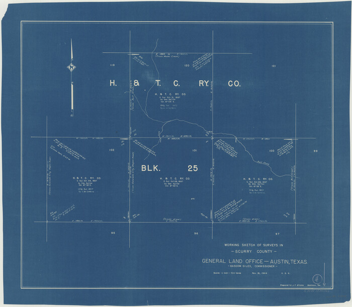
Scurry County Working Sketch 4
Print $20.00
- Digital $50.00
Scurry County Working Sketch 4
1944
Size 23.1 x 26.5 inches
Map/Doc 63833

Flight Mission No. CUG-1P, Frame 27, Kleberg County

Print $20.00
- Digital $50.00
Flight Mission No. CUG-1P, Frame 27, Kleberg County
1956
Size 18.4 x 22.1 inches
Map/Doc 86117
Sketch A Shewing the progress of the Survey in Section No. 1 From 1844 to 1852

Print $20.00
- Digital $50.00
Sketch A Shewing the progress of the Survey in Section No. 1 From 1844 to 1852
1852
Size 38.1 x 25.3 inches
Map/Doc 97200
Angelina County, Nacogdoches District

Print $20.00
- Digital $50.00
Angelina County, Nacogdoches District
1882
Size 20.0 x 27.6 inches
Map/Doc 3234
[Blocks M18, M23, I, Z, and Block 47, Sections 16-28]
![91244, [Blocks M18, M23, I, Z, and Block 47, Sections 16-28], Twichell Survey Records](https://historictexasmaps.com/wmedia_w700/maps/91244-1.tif.jpg)
Print $20.00
- Digital $50.00
[Blocks M18, M23, I, Z, and Block 47, Sections 16-28]
Size 19.5 x 23.6 inches
Map/Doc 91244
Crockett County Sketch File 84

Print $6.00
- Digital $50.00
Crockett County Sketch File 84
1942
Size 11.4 x 8.9 inches
Map/Doc 19905
Blanco County Working Sketch 25

Print $20.00
- Digital $50.00
Blanco County Working Sketch 25
1966
Size 24.8 x 24.8 inches
Map/Doc 67385
Dickens County Sketch File H

Print $28.00
- Digital $50.00
Dickens County Sketch File H
Size 13.2 x 8.9 inches
Map/Doc 20861
Montgomery County Sketch File 5

Print $5.00
- Digital $50.00
Montgomery County Sketch File 5
Size 9.8 x 16.4 inches
Map/Doc 31779
Menard County Working Sketch 20

Print $20.00
- Digital $50.00
Menard County Working Sketch 20
1947
Size 38.5 x 34.9 inches
Map/Doc 70967
Brewster County Working Sketch Graphic Index, South Part

Print $40.00
- Digital $50.00
Brewster County Working Sketch Graphic Index, South Part
1955
Size 48.5 x 40.4 inches
Map/Doc 76475