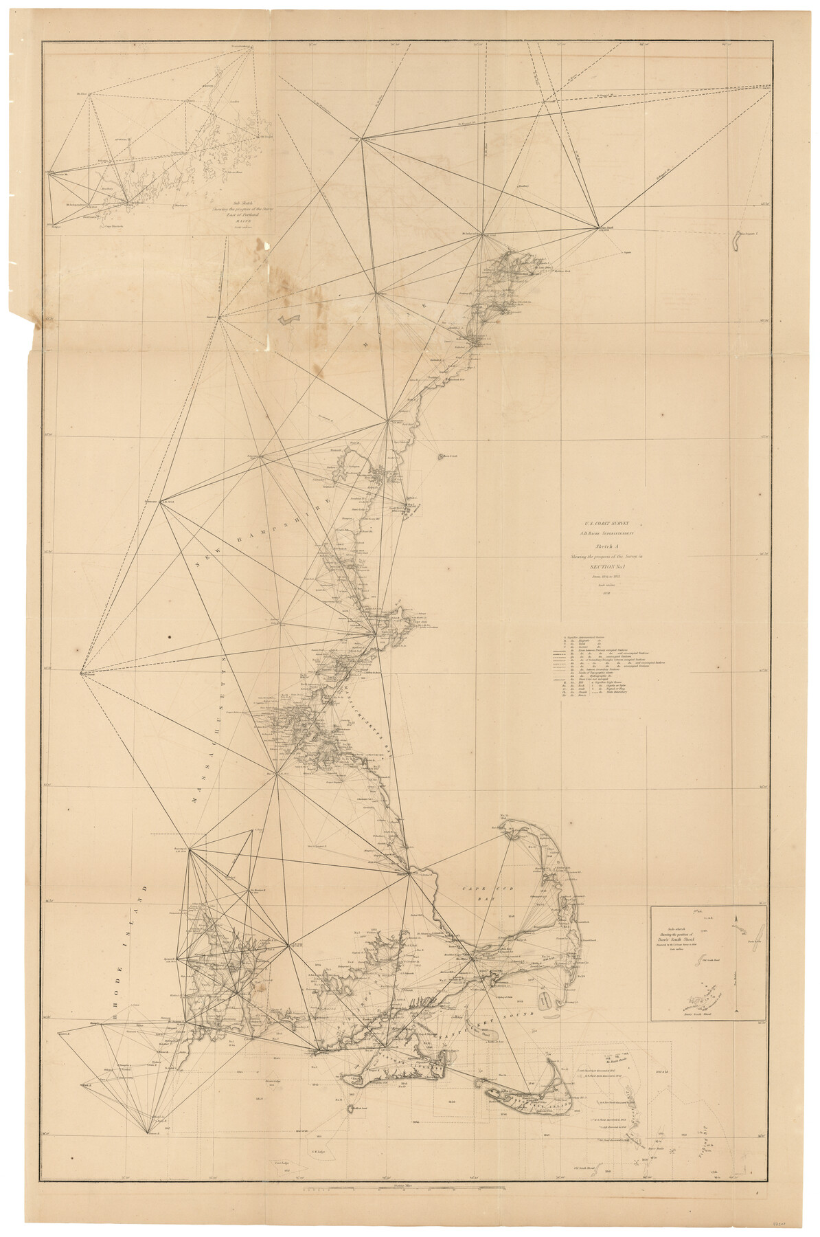
Sketch A Shewing the progress of the Survey in Section No. 1 From 1844 to 1852
-
Map/Doc
97200
-
Collection
General Map Collection
-
Object Dates
1852 (Creation Date)
-
People and Organizations
A.D. Bache (Superintendent)
U.S. Coast Survey (Publisher)
-
Subjects
Coastal
-
Height x Width
38.1 x 25.3 inches
96.8 x 64.3 cm
-
Comments
Sketch from the book "Sketches Accompanying Report of Coast Survey for 1851"
Part of: General Map Collection
Flight Mission No. DQN-2K, Frame 72, Calhoun County

Print $20.00
- Digital $50.00
Flight Mission No. DQN-2K, Frame 72, Calhoun County
1953
Size 18.6 x 22.3 inches
Map/Doc 84264
Wilson County Working Sketch 7

Print $20.00
- Digital $50.00
Wilson County Working Sketch 7
1965
Size 23.7 x 30.2 inches
Map/Doc 72587
Red River County Working Sketch 67

Print $20.00
- Digital $50.00
Red River County Working Sketch 67
1974
Size 46.9 x 37.7 inches
Map/Doc 72050
Presidio County Sketch File 62

Print $10.00
- Digital $50.00
Presidio County Sketch File 62
1938
Size 11.2 x 8.8 inches
Map/Doc 34647
Flight Mission No. CRC-2R, Frame 1, Chambers County

Print $20.00
- Digital $50.00
Flight Mission No. CRC-2R, Frame 1, Chambers County
1956
Size 18.7 x 22.5 inches
Map/Doc 84720
Webb County Working Sketch 96

Print $20.00
- Digital $50.00
Webb County Working Sketch 96
1994
Size 36.1 x 36.3 inches
Map/Doc 72463
Montague County Working Sketch 19

Print $20.00
- Digital $50.00
Montague County Working Sketch 19
1952
Size 26.4 x 21.5 inches
Map/Doc 71085
Map of San Patricio County

Print $40.00
- Digital $50.00
Map of San Patricio County
1840
Size 48.7 x 57.2 inches
Map/Doc 77095
Flight Mission No. BRA-16M, Frame 53, Jefferson County

Print $20.00
- Digital $50.00
Flight Mission No. BRA-16M, Frame 53, Jefferson County
1953
Size 18.4 x 22.6 inches
Map/Doc 85670
Flight Mission No. DIX-5P, Frame 116, Aransas County

Print $20.00
- Digital $50.00
Flight Mission No. DIX-5P, Frame 116, Aransas County
1956
Size 17.8 x 18.1 inches
Map/Doc 83795
Van Zandt County Sketch File 36

Print $4.00
- Digital $50.00
Van Zandt County Sketch File 36
1864
Size 8.0 x 10.4 inches
Map/Doc 39478
Hood County Sketch File 10

Print $20.00
- Digital $50.00
Hood County Sketch File 10
Size 20.6 x 22.9 inches
Map/Doc 11778
You may also like
[Sketch for Mineral Application 35981 - Liberty County, John Mecom]
![65618, [Sketch for Mineral Application 35981 - Liberty County, John Mecom], General Map Collection](https://historictexasmaps.com/wmedia_w700/maps/65618.tif.jpg)
Print $20.00
- Digital $50.00
[Sketch for Mineral Application 35981 - Liberty County, John Mecom]
1941
Size 30.1 x 26.4 inches
Map/Doc 65618
Runnels County Sketch File 7

Print $5.00
Runnels County Sketch File 7
Size 8.3 x 7.7 inches
Map/Doc 35444
Real County Working Sketch 54

Print $20.00
- Digital $50.00
Real County Working Sketch 54
1960
Size 31.0 x 39.5 inches
Map/Doc 71946
Hale County Rolled Sketch 3

Print $40.00
- Digital $50.00
Hale County Rolled Sketch 3
1891
Size 51.7 x 24.1 inches
Map/Doc 9093
[Map showing State Capitol Lands]
![93143, [Map showing State Capitol Lands], Twichell Survey Records](https://historictexasmaps.com/wmedia_w700/maps/93143-1.tif.jpg)
Print $40.00
- Digital $50.00
[Map showing State Capitol Lands]
Size 50.6 x 65.3 inches
Map/Doc 93143
Jasper County Working Sketch 30

Print $20.00
- Digital $50.00
Jasper County Working Sketch 30
1956
Size 33.5 x 38.6 inches
Map/Doc 66492
Nueces County Sketch File 24

Print $2.00
- Digital $50.00
Nueces County Sketch File 24
Size 8.7 x 14.0 inches
Map/Doc 32571
Brewster County Working Sketch 9

Print $20.00
- Digital $50.00
Brewster County Working Sketch 9
1910
Size 14.3 x 14.4 inches
Map/Doc 67542
Terrell County Working Sketch 39

Print $20.00
- Digital $50.00
Terrell County Working Sketch 39
1951
Size 26.8 x 40.4 inches
Map/Doc 62132
Fisher County Rolled Sketch 6

Print $20.00
- Digital $50.00
Fisher County Rolled Sketch 6
1971
Size 26.9 x 26.7 inches
Map/Doc 5877
Flight Mission No. CRC-4R, Frame 73, Chambers County

Print $20.00
- Digital $50.00
Flight Mission No. CRC-4R, Frame 73, Chambers County
1956
Size 18.7 x 22.5 inches
Map/Doc 84877
Val Verde County Sketch File 20

Print $20.00
- Digital $50.00
Val Verde County Sketch File 20
1881
Size 26.5 x 37.2 inches
Map/Doc 12569