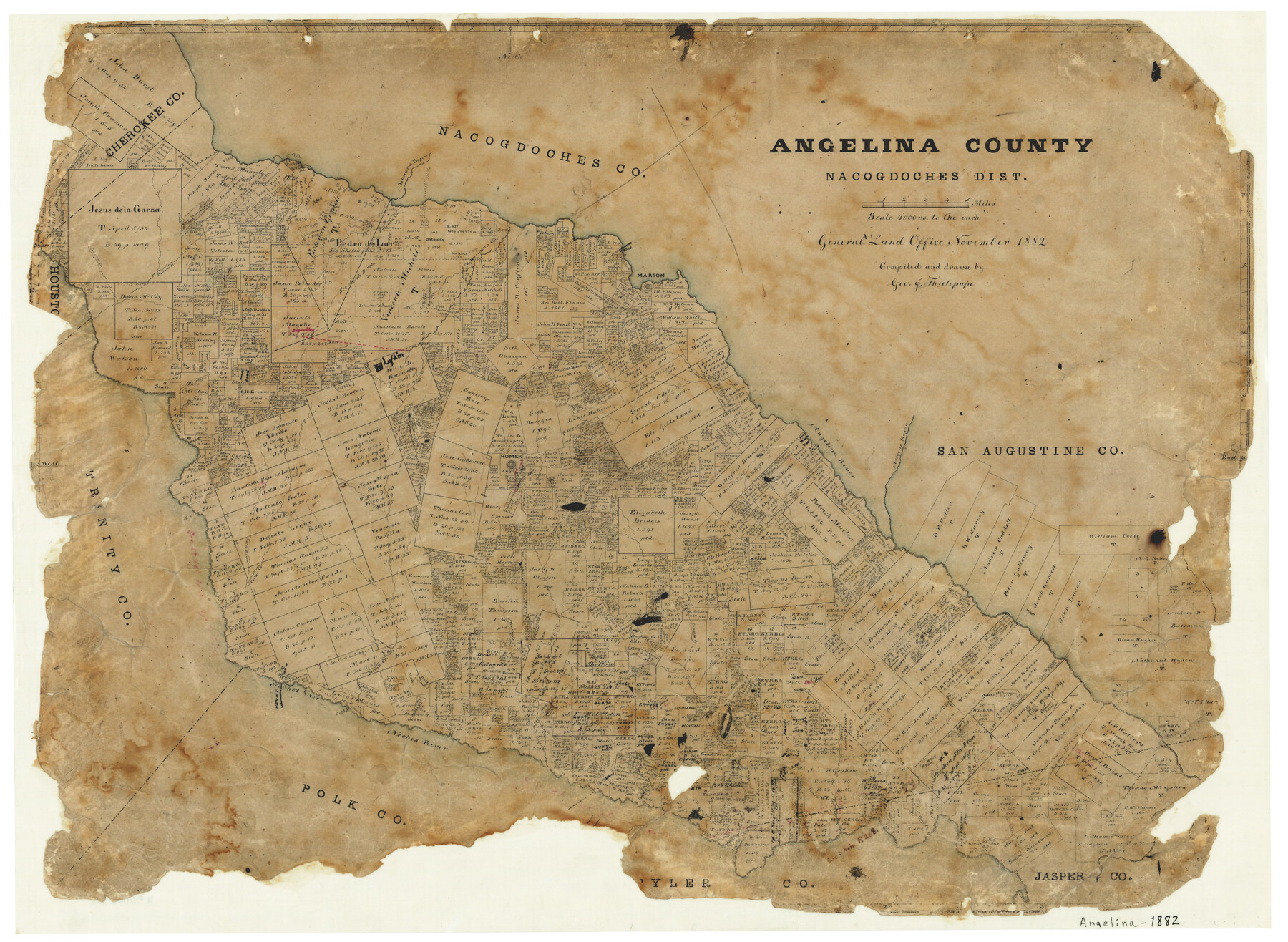
Angelina County, Nacogdoches District
-
Map/Doc
3234
-
Collection
General Map Collection
-
Object Dates
11/1882 (Creation Date)
-
People and Organizations
George J. Thielepape (Compiler)
George J. Thielepape (Draftsman)
-
Counties
Angelina
-
Subjects
County
-
Height x Width
20.0 x 27.6 inches
50.8 x 70.1 cm
-
Scale
1" = 4000 varas
-
Comments
Located in Nacogdoches District.
-
Features
Neches River
Fish Creek
Cypress Creek
Chalk Creek
Mill Creek
Beech Creek
Bear Creek
HE&WT
Pophar [sic] Creek
Stanley Creek
Buell Creek
Lion Creek
Bodano Bayou
Devil's Creek
Shawnee Creek
Stovall Creek
Lanana Bayou
Baluxy [sic] Creek
Cedar Creek
Jack's Bayou
Attoyac Bayou
Angelina River
Homer
Marion
Lufkin
Anderson Creek
Brushy Creek
Cordova Creek
Durazno Creek
Kerr Creek
Procella Creek
Part of: General Map Collection
Brazoria County Rolled Sketch AH

Print $20.00
- Digital $50.00
Brazoria County Rolled Sketch AH
Size 43.9 x 31.2 inches
Map/Doc 10714
Calhoun County Working Sketch 2b

Print $20.00
- Digital $50.00
Calhoun County Working Sketch 2b
1913
Size 17.3 x 15.8 inches
Map/Doc 67818
Railroad Track Map, H&TCRRCo., Falls County, Texas

Print $4.00
- Digital $50.00
Railroad Track Map, H&TCRRCo., Falls County, Texas
1918
Size 11.6 x 18.6 inches
Map/Doc 62852
Liberty County Rolled Sketch 12

Print $20.00
- Digital $50.00
Liberty County Rolled Sketch 12
1983
Size 26.5 x 22.6 inches
Map/Doc 6618
Bandera County

Print $40.00
- Digital $50.00
Bandera County
1947
Size 34.2 x 55.3 inches
Map/Doc 95424
Sabine River, Rocky Ford Crossing Sheet/Cowleach Fork of the Sabine River

Print $20.00
- Digital $50.00
Sabine River, Rocky Ford Crossing Sheet/Cowleach Fork of the Sabine River
1936
Size 38.9 x 29.2 inches
Map/Doc 65144
Crane County Working Sketch 7

Print $20.00
- Digital $50.00
Crane County Working Sketch 7
1929
Size 33.6 x 23.2 inches
Map/Doc 68284
Angelina County Sketch File 26

Print $40.00
- Digital $50.00
Angelina County Sketch File 26
1909
Size 18.0 x 23.0 inches
Map/Doc 10817
Kleberg County Rolled Sketch 10-33

Print $20.00
- Digital $50.00
Kleberg County Rolled Sketch 10-33
1950
Size 36.5 x 32.1 inches
Map/Doc 9393
Cameron County Rolled Sketch 22

Print $63.00
- Digital $50.00
Cameron County Rolled Sketch 22
Size 9.8 x 15.0 inches
Map/Doc 43919
Morris County Rolled Sketch 2A

Print $20.00
- Digital $50.00
Morris County Rolled Sketch 2A
Size 24.0 x 18.8 inches
Map/Doc 10275
Blanco County Sketch File 32

Print $4.00
- Digital $50.00
Blanco County Sketch File 32
1888
Size 8.5 x 11.1 inches
Map/Doc 14633
You may also like
Crockett County Working Sketch 10

Print $20.00
- Digital $50.00
Crockett County Working Sketch 10
1913
Size 23.5 x 21.6 inches
Map/Doc 68343
Coryell County Working Sketch 11

Print $20.00
- Digital $50.00
Coryell County Working Sketch 11
1949
Size 29.7 x 27.5 inches
Map/Doc 68218
Freestone County Working Sketch 8

Print $40.00
- Digital $50.00
Freestone County Working Sketch 8
1960
Size 60.6 x 36.6 inches
Map/Doc 69250
Winkler County Working Sketch 19

Print $20.00
- Digital $50.00
Winkler County Working Sketch 19
1990
Size 29.4 x 25.7 inches
Map/Doc 72613
Trinity County Working Sketch 8

Print $3.00
- Digital $50.00
Trinity County Working Sketch 8
1941
Size 14.7 x 10.8 inches
Map/Doc 69457
Montgomery County Sketch File 4

Print $8.00
- Digital $50.00
Montgomery County Sketch File 4
1854
Size 12.0 x 8.1 inches
Map/Doc 31775
Matagorda County Working Sketch 20

Print $20.00
- Digital $50.00
Matagorda County Working Sketch 20
1961
Size 26.1 x 37.7 inches
Map/Doc 70878
Hopkins County Sketch File 9

Print $6.00
- Digital $50.00
Hopkins County Sketch File 9
1856
Size 12.8 x 8.3 inches
Map/Doc 26697
[Sketch of surveys in Knox County]
![555, [Sketch of surveys in Knox County], Maddox Collection](https://historictexasmaps.com/wmedia_w700/maps/555.tif.jpg)
Print $20.00
- Digital $50.00
[Sketch of surveys in Knox County]
Size 27.1 x 31.1 inches
Map/Doc 555
Crockett County Sketch File 88

Print $3.00
- Digital $50.00
Crockett County Sketch File 88
1958
Size 19.3 x 15.8 inches
Map/Doc 11237
Yoakum County Rolled Sketch 2

Print $20.00
- Digital $50.00
Yoakum County Rolled Sketch 2
1943
Size 18.6 x 33.4 inches
Map/Doc 8288
Where Did Columbus Discover America?

Where Did Columbus Discover America?
1986
Size 14.7 x 20.6 inches
Map/Doc 96837