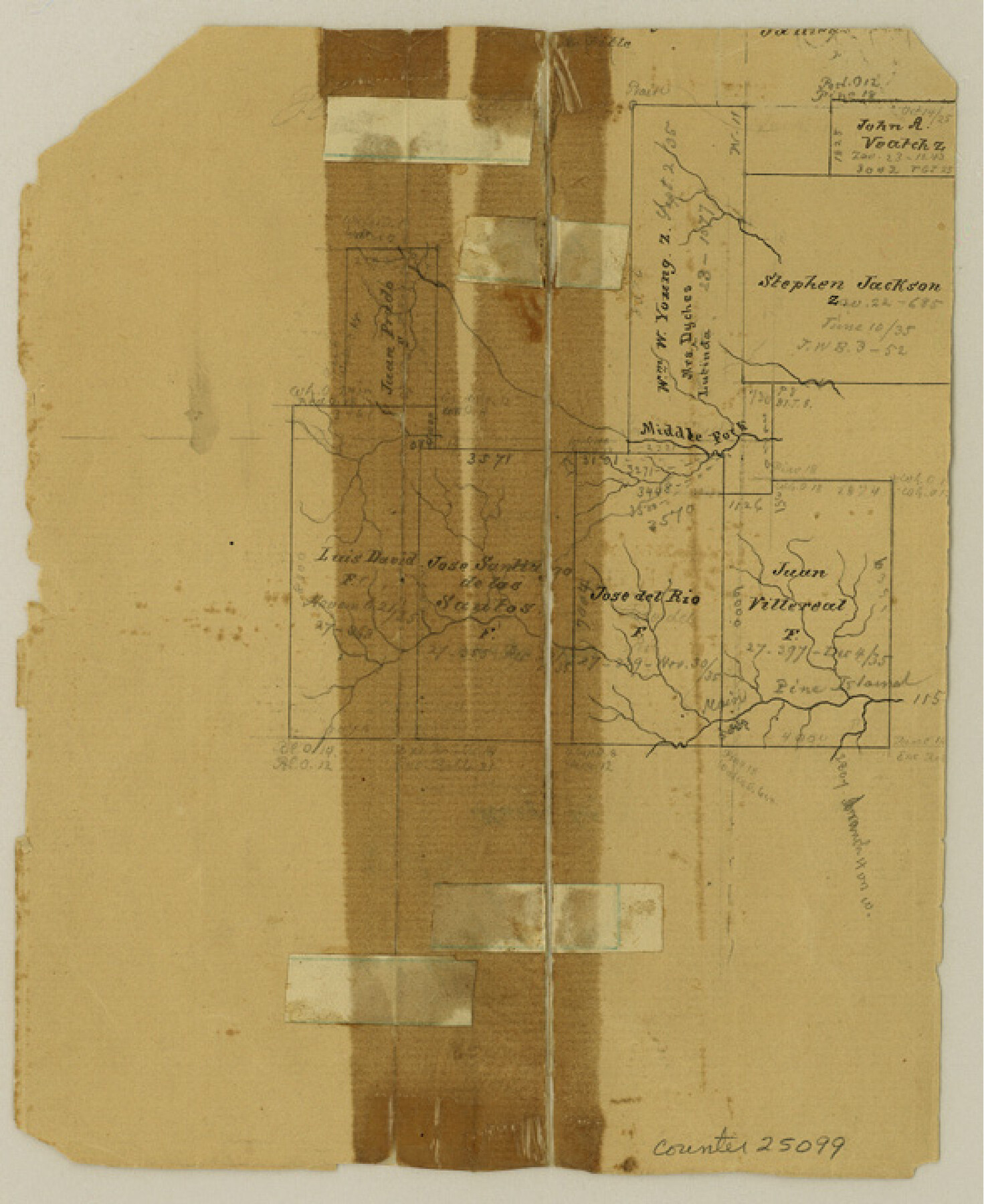
Hardin County Sketch File 7
[Sketch of southern part, Little Island Bayou]
-
Map/Doc
25099
-
Collection
General Map Collection
-
Counties
Hardin Liberty Jefferson
-
Subjects
Surveying Sketch File
-
Height x Width
7.2 x 5.9 inches
18.3 x 15.0 cm
-
Medium
paper, manuscript
-
Features
Pine Island Bayou
Middle Fork of Pine Island Bayou
Part of: General Map Collection
[G.C. and S. F. R.R. Co. Through Bosque County from McLennan Co. and E. to Hill Co. Station M. P. 259 to M. P. 297]
![64564, [G.C. and S. F. R.R. Co. Through Bosque County from McLennan Co. and E. to Hill Co. Station M. P. 259 to M. P. 297], General Map Collection](https://historictexasmaps.com/wmedia_w700/maps/64564-1.tif.jpg)
Print $40.00
- Digital $50.00
[G.C. and S. F. R.R. Co. Through Bosque County from McLennan Co. and E. to Hill Co. Station M. P. 259 to M. P. 297]
1898
Size 22.4 x 101.5 inches
Map/Doc 64564
Brewster County Boundary File 1a

Print $80.00
- Digital $50.00
Brewster County Boundary File 1a
Size 94.0 x 13.8 inches
Map/Doc 50738
Marion County Working Sketch 42

Print $20.00
- Digital $50.00
Marion County Working Sketch 42
2000
Size 29.6 x 41.4 inches
Map/Doc 70818
Map of Hill County

Print $40.00
- Digital $50.00
Map of Hill County
1884
Size 80.0 x 35.2 inches
Map/Doc 93379
[Map of Lt. Brulls scout in Haskell, Throckmorton, Jones and Shackelford Counties]
![65399, [Map of Lt. Brulls scout in Haskell, Throckmorton, Jones and Shackelford Counties], General Map Collection](https://historictexasmaps.com/wmedia_w700/maps/65399-1.tif.jpg)
Print $3.00
- Digital $50.00
[Map of Lt. Brulls scout in Haskell, Throckmorton, Jones and Shackelford Counties]
1873
Size 10.1 x 11.9 inches
Map/Doc 65399
Reagan County Sketch File 1

Print $20.00
- Digital $50.00
Reagan County Sketch File 1
1914
Size 24.3 x 30.3 inches
Map/Doc 12210
Motley County Sketch File B2 (N)

Print $8.00
- Digital $50.00
Motley County Sketch File B2 (N)
Size 8.6 x 6.1 inches
Map/Doc 31970
Brewster County Rolled Sketch 94

Print $40.00
- Digital $50.00
Brewster County Rolled Sketch 94
1941
Size 26.8 x 58.6 inches
Map/Doc 8507
Duval County Sketch File 54

Print $20.00
- Digital $50.00
Duval County Sketch File 54
1937
Size 19.0 x 26.4 inches
Map/Doc 11403
Anderson County Rolled Sketch 7

Print $20.00
- Digital $50.00
Anderson County Rolled Sketch 7
1941
Size 42.2 x 44.9 inches
Map/Doc 8364
Hemphill County Working Sketch Graphic Index - sheet 1

Print $20.00
- Digital $50.00
Hemphill County Working Sketch Graphic Index - sheet 1
1899
Size 40.1 x 38.2 inches
Map/Doc 76574
Crockett County Rolled Sketch 46C

Print $20.00
- Digital $50.00
Crockett County Rolled Sketch 46C
Size 24.5 x 23.8 inches
Map/Doc 5595
You may also like
PSL Field Notes for Blocks B13, B18, and B28 in Crane and Ward Counties, and Blocks B19, B20, and B29 in Ward County

PSL Field Notes for Blocks B13, B18, and B28 in Crane and Ward Counties, and Blocks B19, B20, and B29 in Ward County
Map/Doc 81647
Reagan County Sketch File 17

Print $40.00
- Digital $50.00
Reagan County Sketch File 17
Size 11.8 x 14.2 inches
Map/Doc 35006
Cherokee County Rolled Sketch 2

Print $20.00
- Digital $50.00
Cherokee County Rolled Sketch 2
1954
Size 44.6 x 36.0 inches
Map/Doc 8596
Val Verde County Rolled Sketch 62

Print $40.00
- Digital $50.00
Val Verde County Rolled Sketch 62
1956
Size 34.6 x 52.1 inches
Map/Doc 10081
Cherokee County Sketch File 18

Print $4.00
- Digital $50.00
Cherokee County Sketch File 18
1870
Size 10.2 x 8.1 inches
Map/Doc 18159
Presidio County Rolled Sketch 119

Print $20.00
- Digital $50.00
Presidio County Rolled Sketch 119
1982
Size 30.6 x 27.2 inches
Map/Doc 7394
Cottle County Sketch File 6

Print $20.00
- Digital $50.00
Cottle County Sketch File 6
1883
Size 20.3 x 29.8 inches
Map/Doc 11190
Flight Mission No. CUG-2P, Frame 64, Kleberg County

Print $20.00
- Digital $50.00
Flight Mission No. CUG-2P, Frame 64, Kleberg County
1956
Size 18.4 x 22.2 inches
Map/Doc 86201
Map of Capitol Syndicate Subdivisions of Capitol Land Reservation Leagues

Print $40.00
- Digital $50.00
Map of Capitol Syndicate Subdivisions of Capitol Land Reservation Leagues
1906
Size 44.6 x 72.6 inches
Map/Doc 93131
Flight Mission No. DQO-7K, Frame 105, Galveston County

Print $20.00
- Digital $50.00
Flight Mission No. DQO-7K, Frame 105, Galveston County
1952
Size 18.4 x 21.8 inches
Map/Doc 85120
Nueces County Sketch File 12A

Print $20.00
- Digital $50.00
Nueces County Sketch File 12A
1889
Size 28.1 x 23.0 inches
Map/Doc 42177
Shelby County Sketch File 16 1/2

Print $4.00
- Digital $50.00
Shelby County Sketch File 16 1/2
Size 7.6 x 5.3 inches
Map/Doc 36629