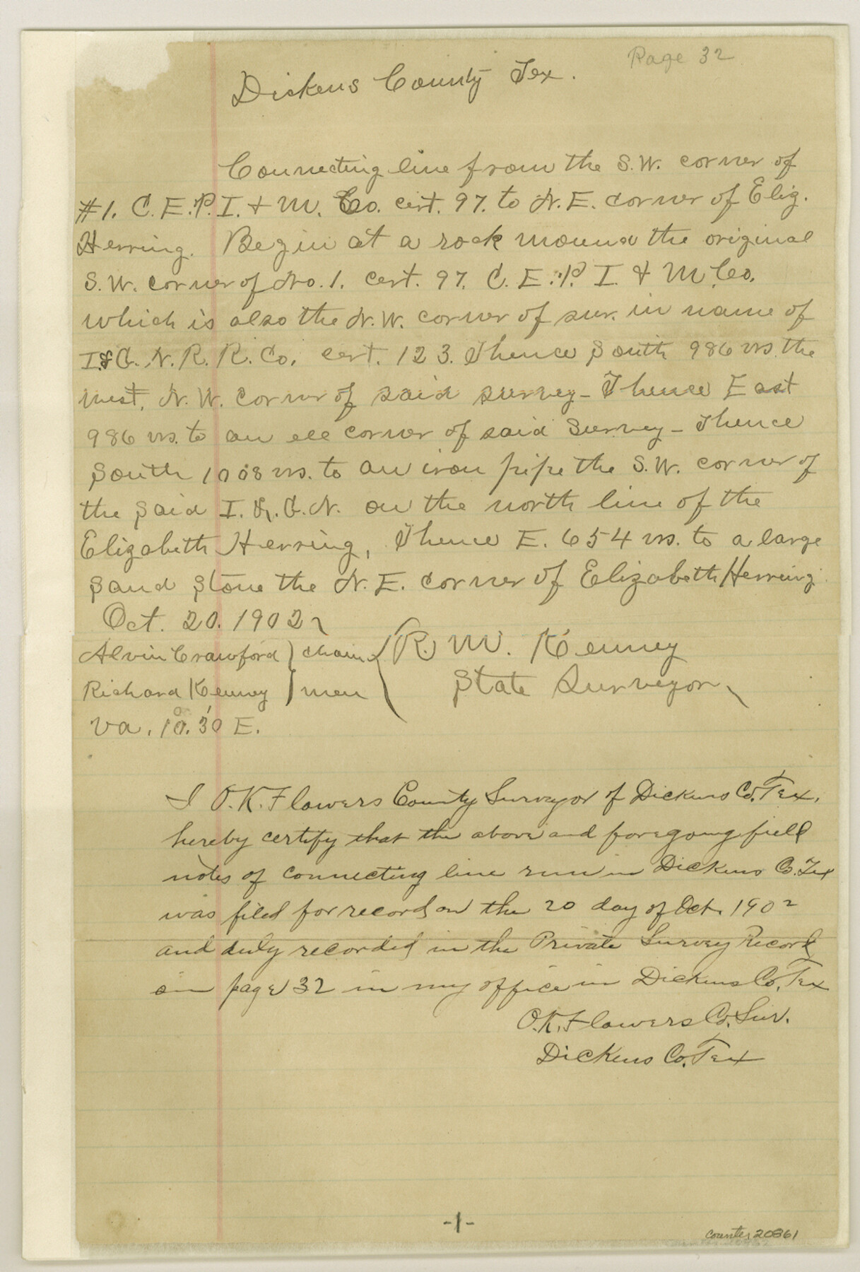
Dickens County Sketch File H
[Connecting lines of surveys in northern part of the county]
-
Map/Doc
20861
-
Collection
General Map Collection
-
Object Dates
1902/11/3 (File Date)
1902/10/20 (Survey Date)
-
People and Organizations
R.M. Kenney (Surveyor/Engineer)
Alvin Crawford (Chainman)
Richard Kenney (Chainman)
Samuel Chalk (Surveyor/Engineer)
George Spiller (Surveyor/Engineer)
-
Counties
Dickens
-
Subjects
Surveying Sketch File
-
Height x Width
13.2 x 8.9 inches
33.5 x 22.6 cm
-
Medium
paper, manuscript
-
Features
Little Croton Creek
Abby Peak
Wichita River
Jackson Branch [of Tongue River]
Part of: General Map Collection
Intracoastal Waterway in Texas - Corpus Christi to Point Isabel including Arroyo Colorado to Mo. Pac. R.R. Bridge Near Harlingen

Print $20.00
- Digital $50.00
Intracoastal Waterway in Texas - Corpus Christi to Point Isabel including Arroyo Colorado to Mo. Pac. R.R. Bridge Near Harlingen
1933
Size 27.5 x 40.6 inches
Map/Doc 61869
Val Verde County Sketch File 37

Print $24.00
- Digital $50.00
Val Verde County Sketch File 37
1938
Size 15.5 x 22.3 inches
Map/Doc 12578

Stonewall County Rolled Sketch 9

Print $20.00
- Digital $50.00
Stonewall County Rolled Sketch 9
Size 35.8 x 30.8 inches
Map/Doc 7865
San Jacinto County Working Sketch 17

Print $40.00
- Digital $50.00
San Jacinto County Working Sketch 17
1934
Size 36.6 x 48.2 inches
Map/Doc 63730
Lavaca County Working Sketch 19

Print $20.00
- Digital $50.00
Lavaca County Working Sketch 19
1980
Size 26.9 x 29.6 inches
Map/Doc 70372
Flight Mission No. BQY-14M, Frame 184, Harris County

Print $20.00
- Digital $50.00
Flight Mission No. BQY-14M, Frame 184, Harris County
1953
Size 18.6 x 22.4 inches
Map/Doc 85300
Tarrant County Sketch File 1

Print $4.00
- Digital $50.00
Tarrant County Sketch File 1
1851
Size 10.2 x 7.9 inches
Map/Doc 37672
Anderson County Working Sketch 23

Print $20.00
- Digital $50.00
Anderson County Working Sketch 23
1958
Size 23.1 x 24.8 inches
Map/Doc 67023
Gradient Boundary Survey of Canadian River through portions of Hutchinson & Roberts Counties, Texas

Print $40.00
- Digital $50.00
Gradient Boundary Survey of Canadian River through portions of Hutchinson & Roberts Counties, Texas
1989
Size 39.6 x 139.0 inches
Map/Doc 3120
Map of Lipscomb County

Print $20.00
- Digital $50.00
Map of Lipscomb County
1899
Size 42.2 x 38.9 inches
Map/Doc 95572
Padre Island National Seashore

Print $4.00
- Digital $50.00
Padre Island National Seashore
Size 16.2 x 22.1 inches
Map/Doc 60530
You may also like
Navigation Maps of Gulf Intracoastal Waterway, Port Arthur to Brownsville, Texas

Print $4.00
- Digital $50.00
Navigation Maps of Gulf Intracoastal Waterway, Port Arthur to Brownsville, Texas
1951
Size 16.7 x 21.5 inches
Map/Doc 65441
Flight Mission No. DCL-5C, Frame 27, Kenedy County

Print $20.00
- Digital $50.00
Flight Mission No. DCL-5C, Frame 27, Kenedy County
1943
Size 18.5 x 22.4 inches
Map/Doc 85839
Sabine County Working Sketch 3

Print $3.00
- Digital $50.00
Sabine County Working Sketch 3
1911
Size 10.8 x 15.7 inches
Map/Doc 63674
General Highway Map, Houston County, Texas

Print $20.00
General Highway Map, Houston County, Texas
1961
Size 24.7 x 18.2 inches
Map/Doc 79525
Flight Mission No. DIX-7P, Frame 89, Aransas County

Print $20.00
- Digital $50.00
Flight Mission No. DIX-7P, Frame 89, Aransas County
1956
Size 18.7 x 22.4 inches
Map/Doc 83883
Cooke County Boundary File 1a

Print $32.00
- Digital $50.00
Cooke County Boundary File 1a
Size 12.6 x 7.5 inches
Map/Doc 51828
Map of Caldwell Co.

Print $40.00
- Digital $50.00
Map of Caldwell Co.
1917
Size 48.4 x 43.0 inches
Map/Doc 89748
[PSL Block A-12]
![93229, [PSL Block A-12], Twichell Survey Records](https://historictexasmaps.com/wmedia_w700/maps/93229-1.tif.jpg)
Print $2.00
- Digital $50.00
[PSL Block A-12]
1953
Size 8.7 x 13.5 inches
Map/Doc 93229
Bailey County Sketch File 11a

Print $4.00
- Digital $50.00
Bailey County Sketch File 11a
1912
Size 8.4 x 11.1 inches
Map/Doc 13967

Swisher Co. Texas

Print $20.00
- Digital $50.00
Swisher Co. Texas
1936
Size 36.8 x 38.0 inches
Map/Doc 89876
Flight Mission No. CUG-1P, Frame 76, Kleberg County

Print $20.00
- Digital $50.00
Flight Mission No. CUG-1P, Frame 76, Kleberg County
1956
Size 18.6 x 22.3 inches
Map/Doc 86141