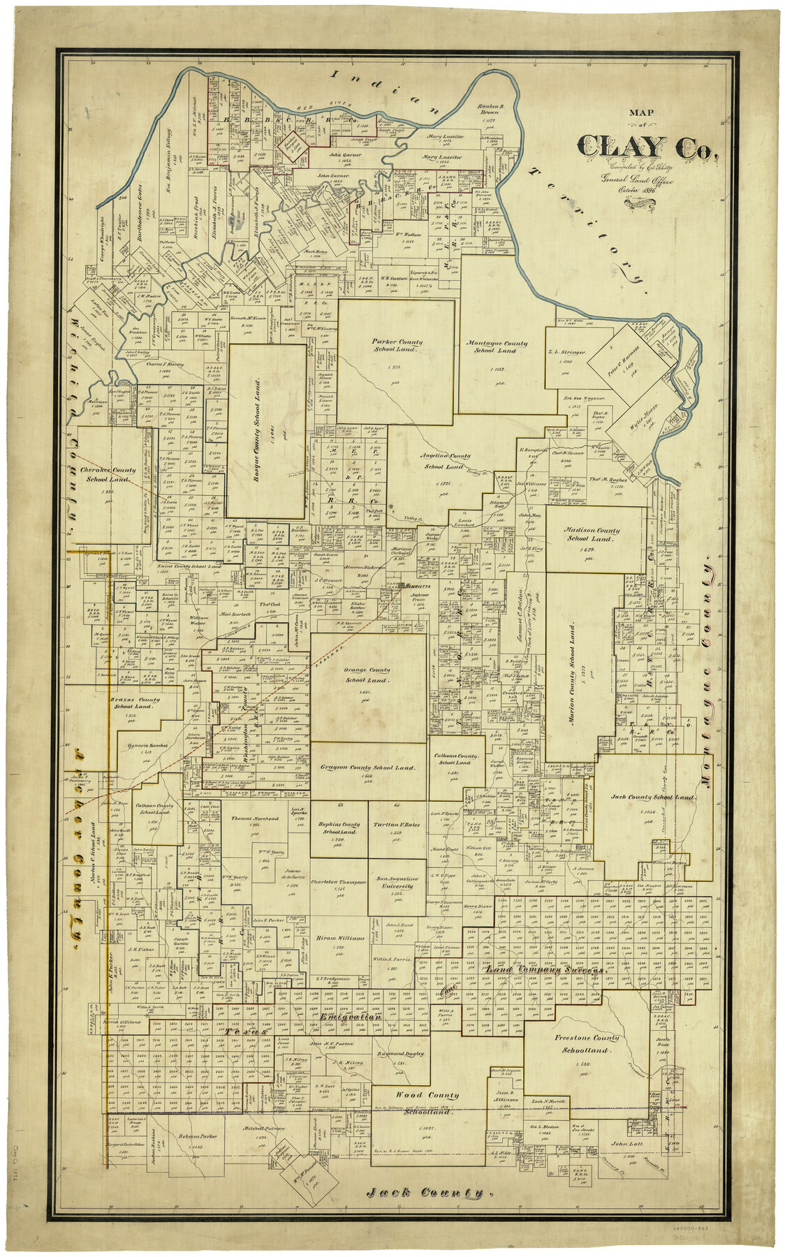
Map of Clay Co.
-
Map/Doc
4910
-
Collection
General Map Collection
-
Object Dates
10/1896 (Creation Date)
-
People and Organizations
Ed. Schutze (Compiler)
F.G. Blau (Draftsman)
-
Counties
Clay
-
Subjects
County
-
Height x Width
53.8 x 34.6 inches
136.7 x 87.9 cm
Part of: General Map Collection
[Galveston, Harrisburg & San Antonio Railroad from Cuero to Stockdale]
![64189, [Galveston, Harrisburg & San Antonio Railroad from Cuero to Stockdale], General Map Collection](https://historictexasmaps.com/wmedia_w700/maps/64189.tif.jpg)
Print $20.00
- Digital $50.00
[Galveston, Harrisburg & San Antonio Railroad from Cuero to Stockdale]
1907
Size 13.8 x 34.0 inches
Map/Doc 64189
Zapata County Rolled Sketch 7

Print $20.00
- Digital $50.00
Zapata County Rolled Sketch 7
1912
Size 18.1 x 27.9 inches
Map/Doc 8308
King County Boundary File 5

Print $12.00
- Digital $50.00
King County Boundary File 5
Size 14.2 x 8.8 inches
Map/Doc 64916
Bastrop County Sketch File 11

Print $52.00
- Digital $50.00
Bastrop County Sketch File 11
Size 11.2 x 8.7 inches
Map/Doc 14058
Coast Chart No. 212 - From Latitude 26° 33' to the Rio Grande, Texas

Print $20.00
- Digital $50.00
Coast Chart No. 212 - From Latitude 26° 33' to the Rio Grande, Texas
1886
Size 30.5 x 24.1 inches
Map/Doc 73504
Williamson County

Print $40.00
- Digital $50.00
Williamson County
1888
Size 39.3 x 57.1 inches
Map/Doc 16929
La Salle County Sketch File 38

Print $40.00
- Digital $50.00
La Salle County Sketch File 38
Size 13.7 x 14.5 inches
Map/Doc 29590
Andrews County Sketch File 5

Print $4.00
- Digital $50.00
Andrews County Sketch File 5
1936
Size 11.8 x 8.8 inches
Map/Doc 12823
Grayson County Working Sketch 27

Print $20.00
- Digital $50.00
Grayson County Working Sketch 27
1988
Size 29.8 x 35.9 inches
Map/Doc 63266
Refugio County Sketch File 2

Print $6.00
- Digital $50.00
Refugio County Sketch File 2
1846
Size 12.6 x 7.7 inches
Map/Doc 35238
Upton County Sketch File 21

Print $20.00
- Digital $50.00
Upton County Sketch File 21
1927
Size 15.0 x 23.7 inches
Map/Doc 12518
Floyd County Sketch File 8

Print $40.00
- Digital $50.00
Floyd County Sketch File 8
1878
Map/Doc 93784
You may also like
Swisher County Working Sketch 6

Print $20.00
- Digital $50.00
Swisher County Working Sketch 6
1979
Size 23.2 x 19.7 inches
Map/Doc 62417
Gregg County Sketch File 4

Print $20.00
- Digital $50.00
Gregg County Sketch File 4
1931
Size 22.1 x 16.6 inches
Map/Doc 11586
Kimble County Working Sketch 84

Print $20.00
- Digital $50.00
Kimble County Working Sketch 84
1972
Size 32.5 x 30.7 inches
Map/Doc 70152
Hays County Boundary File 2a

Print $40.00
- Digital $50.00
Hays County Boundary File 2a
Size 9.0 x 25.0 inches
Map/Doc 54595

Limestone County Sketch File 26

Print $12.00
- Digital $50.00
Limestone County Sketch File 26
Size 14.3 x 8.7 inches
Map/Doc 30210
[Surveys in the Bexar District in the vicinity of Salado and Saltillo Creeks]
![234, [Surveys in the Bexar District in the vicinity of Salado and Saltillo Creeks], General Map Collection](https://historictexasmaps.com/wmedia_w700/maps/234.tif.jpg)
Print $2.00
- Digital $50.00
[Surveys in the Bexar District in the vicinity of Salado and Saltillo Creeks]
1847
Size 10.3 x 9.1 inches
Map/Doc 234
San Luis Pass to East Matagorda Bay

Print $20.00
- Digital $50.00
San Luis Pass to East Matagorda Bay
1972
Size 34.7 x 47.2 inches
Map/Doc 69967
Map of Cherokee County

Print $20.00
- Digital $50.00
Map of Cherokee County
1863
Size 25.5 x 17.7 inches
Map/Doc 3387
Harris County Working Sketch 75

Print $20.00
- Digital $50.00
Harris County Working Sketch 75
1964
Size 29.7 x 32.3 inches
Map/Doc 65967
Montgomery County Sketch File 4

Print $8.00
- Digital $50.00
Montgomery County Sketch File 4
1854
Size 12.0 x 8.1 inches
Map/Doc 31775
Jefferson County Rolled Sketch 61D

Print $20.00
- Digital $50.00
Jefferson County Rolled Sketch 61D
Size 27.2 x 40.5 inches
Map/Doc 6413