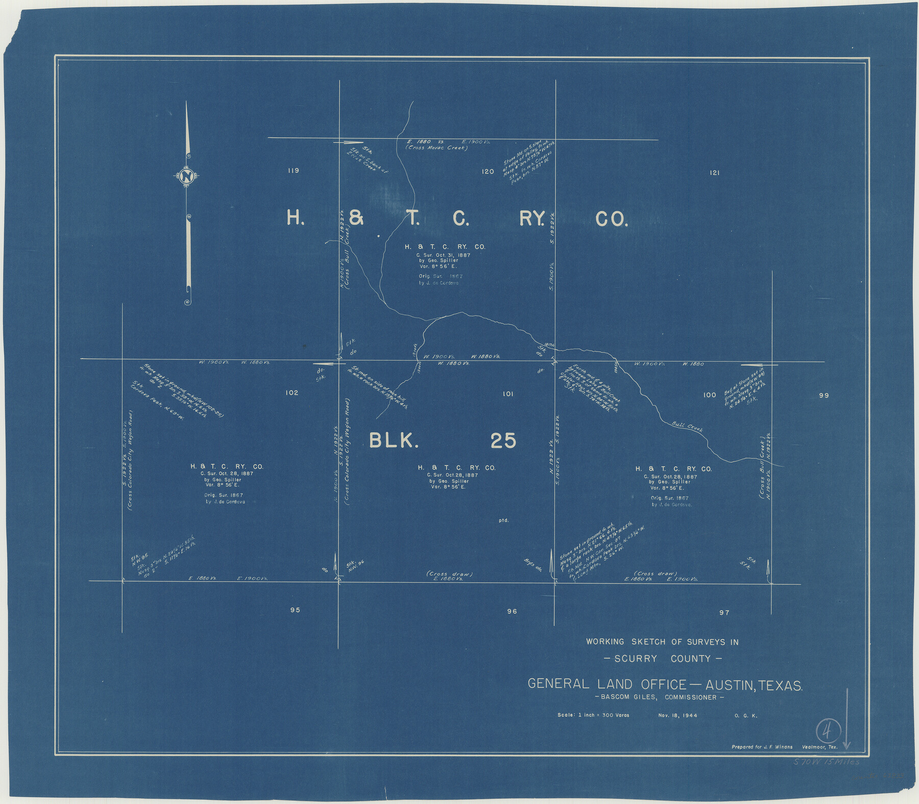
Scurry County Working Sketch 4
-
Map/Doc
63833
-
Collection
General Map Collection
-
Object Dates
11/18/1944 (Creation Date)
-
People and Organizations
Otto G. Kurio (Draftsman)
-
Counties
Scurry
-
Subjects
Surveying Working Sketch
-
Height x Width
23.1 x 26.5 inches
58.7 x 67.3 cm
-
Scale
1" = 300 varas
Part of: General Map Collection
Lampasas County Working Sketch 24

Print $20.00
- Digital $50.00
Lampasas County Working Sketch 24
Size 14.3 x 13.3 inches
Map/Doc 61796
La Salle County

Print $20.00
- Digital $50.00
La Salle County
1923
Size 39.7 x 34.5 inches
Map/Doc 77348
Terry County Sketch File 10

Print $20.00
- Digital $50.00
Terry County Sketch File 10
Size 10.8 x 43.2 inches
Map/Doc 10394
[Sketch for Mineral Application 16700 - Pecos River Bed]
![2811, [Sketch for Mineral Application 16700 - Pecos River Bed], General Map Collection](https://historictexasmaps.com/wmedia_w700/maps/2811.tif.jpg)
Print $20.00
- Digital $50.00
[Sketch for Mineral Application 16700 - Pecos River Bed]
1927
Size 20.6 x 28.6 inches
Map/Doc 2811
Throckmorton County Sketch File 13

Print $20.00
- Digital $50.00
Throckmorton County Sketch File 13
1994
Size 11.3 x 9.1 inches
Map/Doc 38120
Flight Mission No. BRA-3M, Frame 194, Jefferson County

Print $20.00
- Digital $50.00
Flight Mission No. BRA-3M, Frame 194, Jefferson County
1953
Size 18.8 x 22.4 inches
Map/Doc 85409
Uvalde County Working Sketch 43

Print $20.00
- Digital $50.00
Uvalde County Working Sketch 43
1978
Size 29.3 x 27.7 inches
Map/Doc 72113
Jefferson County Working Sketch 26

Print $20.00
- Digital $50.00
Jefferson County Working Sketch 26
1977
Size 39.9 x 36.8 inches
Map/Doc 66569
Flight Mission No. DQN-1K, Frame 73, Calhoun County

Print $20.00
- Digital $50.00
Flight Mission No. DQN-1K, Frame 73, Calhoun County
1953
Size 18.5 x 22.2 inches
Map/Doc 84160
Wharton County Working Sketch 11

Print $20.00
- Digital $50.00
Wharton County Working Sketch 11
1976
Size 42.2 x 40.8 inches
Map/Doc 72475
Red River County Working Sketch 73

Print $20.00
- Digital $50.00
Red River County Working Sketch 73
1979
Size 17.0 x 19.2 inches
Map/Doc 72056
Archer County Working Sketch 10a

Print $20.00
- Digital $50.00
Archer County Working Sketch 10a
1924
Size 25.9 x 40.6 inches
Map/Doc 67150
You may also like
[Map showing resurvey of Capitol Leagues, Hartley County, Texas]
![1760, [Map showing resurvey of Capitol Leagues, Hartley County, Texas], General Map Collection](https://historictexasmaps.com/wmedia_w700/maps/1760-1.tif.jpg)
Print $20.00
- Digital $50.00
[Map showing resurvey of Capitol Leagues, Hartley County, Texas]
1918
Size 30.6 x 47.8 inches
Map/Doc 1760
Young County Rolled Sketch 5

Print $20.00
- Digital $50.00
Young County Rolled Sketch 5
Size 20.2 x 26.1 inches
Map/Doc 8293
Howard County Boundary File 4a

Print $60.00
- Digital $50.00
Howard County Boundary File 4a
Size 70.6 x 10.0 inches
Map/Doc 55166
El Paso County Rolled Sketch 33

Print $42.00
- Digital $50.00
El Paso County Rolled Sketch 33
Size 35.1 x 25.6 inches
Map/Doc 8867
Motley County Sketch File B4 (N)

Print $20.00
- Digital $50.00
Motley County Sketch File B4 (N)
1900
Size 23.5 x 25.8 inches
Map/Doc 42151
Duval County Boundary File 1d

Print $40.00
- Digital $50.00
Duval County Boundary File 1d
Size 6.6 x 47.7 inches
Map/Doc 52699
Edwards County Sketch File 5

Print $5.00
- Digital $50.00
Edwards County Sketch File 5
Size 9.0 x 3.9 inches
Map/Doc 21682
Van Zandt County Sketch File 35

Print $4.00
- Digital $50.00
Van Zandt County Sketch File 35
1862
Size 12.7 x 8.2 inches
Map/Doc 39474
Sketch showing the Connnecting Lines run by Olliver Hedgcoxe for the Texan Emigration and Land Company connecting their Surveys made by them in Peters' Colony, Texas

Print $40.00
- Digital $50.00
Sketch showing the Connnecting Lines run by Olliver Hedgcoxe for the Texan Emigration and Land Company connecting their Surveys made by them in Peters' Colony, Texas
1854
Size 45.8 x 61.9 inches
Map/Doc 1969
[I. M. Bolton, L. S. Thacker, and R. C. Poteet Subdivisions]
![92579, [I. M. Bolton, L. S. Thacker, and R. C. Poteet Subdivisions], Twichell Survey Records](https://historictexasmaps.com/wmedia_w700/maps/92579-1.tif.jpg)
Print $20.00
- Digital $50.00
[I. M. Bolton, L. S. Thacker, and R. C. Poteet Subdivisions]
1924
Size 18.3 x 24.8 inches
Map/Doc 92579
San Patricio County

Print $20.00
- Digital $50.00
San Patricio County
1939
Size 31.6 x 41.6 inches
Map/Doc 77416
[Map of Matagorda County]
![3841, [Map of Matagorda County], General Map Collection](https://historictexasmaps.com/wmedia_w700/maps/3841.tif.jpg)
Print $20.00
- Digital $50.00
[Map of Matagorda County]
Size 24.4 x 25.6 inches
Map/Doc 3841