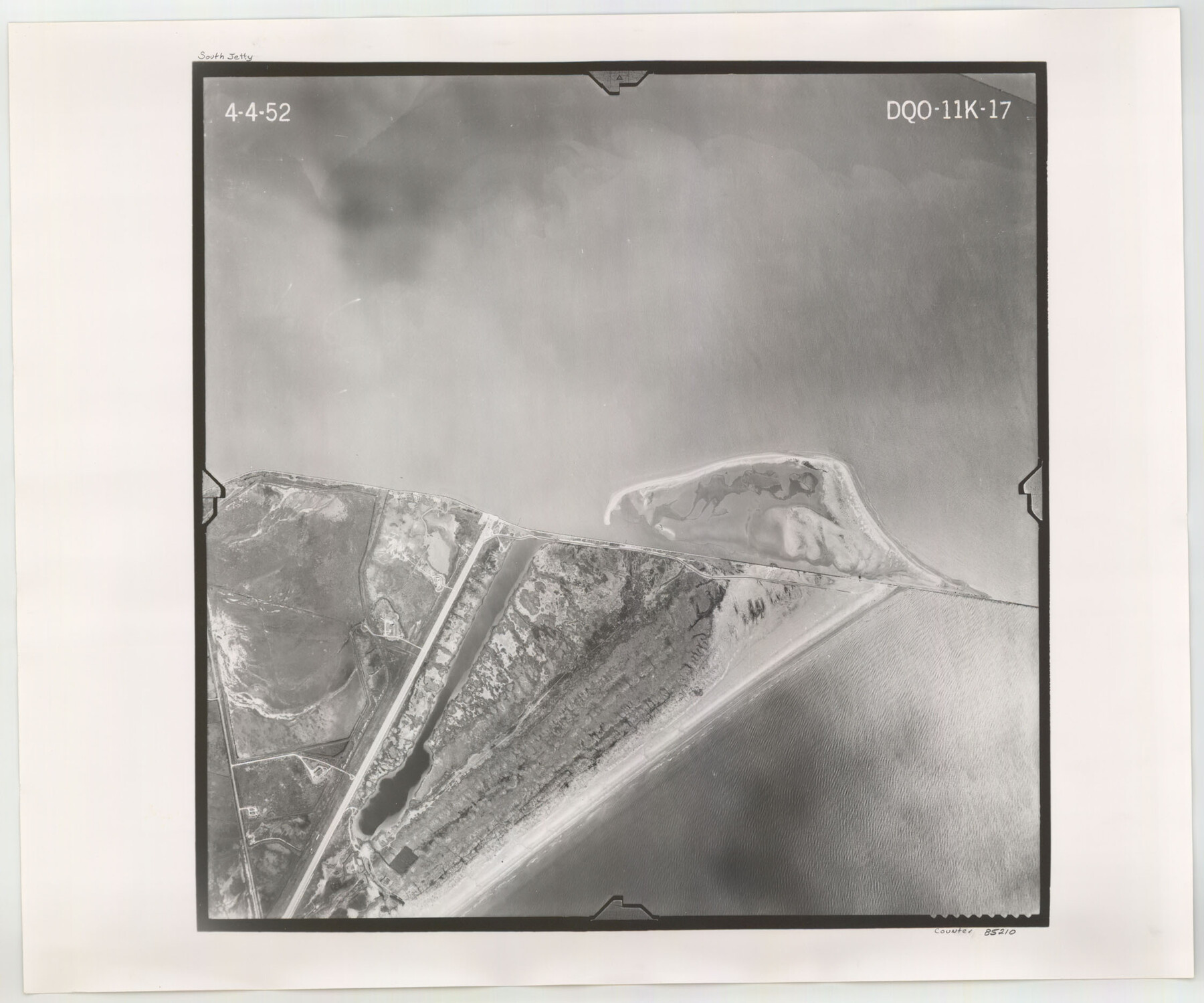
Flight Mission No. DQO-11K, Frame 17, Galveston County
DQO-11K-17
-
Map/Doc
85210
-
Collection
General Map Collection
-
Object Dates
1952/4/4 (Creation Date)
-
People and Organizations
U. S. Department of Agriculture (Publisher)
-
Counties
Galveston
-
Subjects
Aerial Photograph
-
Height x Width
18.7 x 22.4 inches
47.5 x 56.9 cm
-
Comments
Flown by Aero Exploration Company of Tulsa, Oklahoma.
Part of: General Map Collection
Flight Mission No. BRA-16M, Frame 174, Jefferson County

Print $20.00
- Digital $50.00
Flight Mission No. BRA-16M, Frame 174, Jefferson County
1953
Size 18.6 x 22.4 inches
Map/Doc 85772
Cass County Working Sketch 14

Print $20.00
- Digital $50.00
Cass County Working Sketch 14
1956
Size 36.7 x 26.4 inches
Map/Doc 67917
Anderson County Working Sketch 23

Print $20.00
- Digital $50.00
Anderson County Working Sketch 23
1958
Size 23.1 x 24.8 inches
Map/Doc 67023
Flight Mission No. DCL-6C, Frame 51, Kenedy County

Print $20.00
- Digital $50.00
Flight Mission No. DCL-6C, Frame 51, Kenedy County
1943
Size 18.6 x 22.4 inches
Map/Doc 85893
Harris County NRC Article 33.136 Sketch 20

Print $22.00
- Digital $50.00
Harris County NRC Article 33.136 Sketch 20
2022
Map/Doc 96896

Baylor County Boundary File 6

Print $82.00
- Digital $50.00
Baylor County Boundary File 6
Size 9.5 x 65.3 inches
Map/Doc 50400

Karnes County Sketch File 8

Print $78.00
- Digital $50.00
Karnes County Sketch File 8
1876
Size 12.7 x 8.2 inches
Map/Doc 28565
Hudspeth County Rolled Sketch 41

Print $40.00
- Digital $50.00
Hudspeth County Rolled Sketch 41
1947
Size 12.6 x 83.1 inches
Map/Doc 76043
Lamar County Sketch File 12

Print $20.00
- Digital $50.00
Lamar County Sketch File 12
Size 19.5 x 23.3 inches
Map/Doc 11967
Hardeman County Sketch File 4

Print $6.00
- Digital $50.00
Hardeman County Sketch File 4
Size 9.3 x 8.2 inches
Map/Doc 24991
You may also like
Gaines County Working Sketch 37

Print $20.00
- Digital $50.00
Gaines County Working Sketch 37
Size 21.5 x 16.6 inches
Map/Doc 69337
Vias de Comunicacion y Movimiento Maritimo

Print $20.00
- Digital $50.00
Vias de Comunicacion y Movimiento Maritimo
Size 26.1 x 34.2 inches
Map/Doc 96800
Anderson County Boundary File 7

Print $10.00
- Digital $50.00
Anderson County Boundary File 7
Size 14.4 x 8.9 inches
Map/Doc 49751
Wheeler County Sketch File 9

Print $12.00
- Digital $50.00
Wheeler County Sketch File 9
1989
Size 11.8 x 9.1 inches
Map/Doc 40008
Bird's Eye View of El Paso

Print $20.00
Bird's Eye View of El Paso
1885
Size 20.0 x 30.0 inches
Map/Doc 93621
General Highway Map. Detail of Cities and Towns in Nueces County, Texas [Corpus Christi and vicinity]
![79617, General Highway Map. Detail of Cities and Towns in Nueces County, Texas [Corpus Christi and vicinity], Texas State Library and Archives](https://historictexasmaps.com/wmedia_w700/maps/79617.tif.jpg)
Print $20.00
General Highway Map. Detail of Cities and Towns in Nueces County, Texas [Corpus Christi and vicinity]
1961
Size 24.6 x 18.1 inches
Map/Doc 79617
Nolan County Sketch File B

Print $20.00
- Digital $50.00
Nolan County Sketch File B
1902
Size 12.0 x 21.5 inches
Map/Doc 42171
Austin County Sketch File 6a

Print $14.00
- Digital $50.00
Austin County Sketch File 6a
1895
Size 11.2 x 8.6 inches
Map/Doc 13865
Pecos County Rolled Sketch JAS

Print $20.00
- Digital $50.00
Pecos County Rolled Sketch JAS
1937
Size 34.9 x 31.4 inches
Map/Doc 9744
Reeves County

Print $20.00
- Digital $50.00
Reeves County
1915
Size 23.6 x 29.8 inches
Map/Doc 92896
[Blocks CC41 and 8]
![90550, [Blocks CC41 and 8], Twichell Survey Records](https://historictexasmaps.com/wmedia_w700/maps/90550-1.tif.jpg)
Print $2.00
- Digital $50.00
[Blocks CC41 and 8]
Size 15.5 x 8.3 inches
Map/Doc 90550
Wharton County Working Sketch 10

Print $20.00
- Digital $50.00
Wharton County Working Sketch 10
1980
Size 23.6 x 18.7 inches
Map/Doc 72474