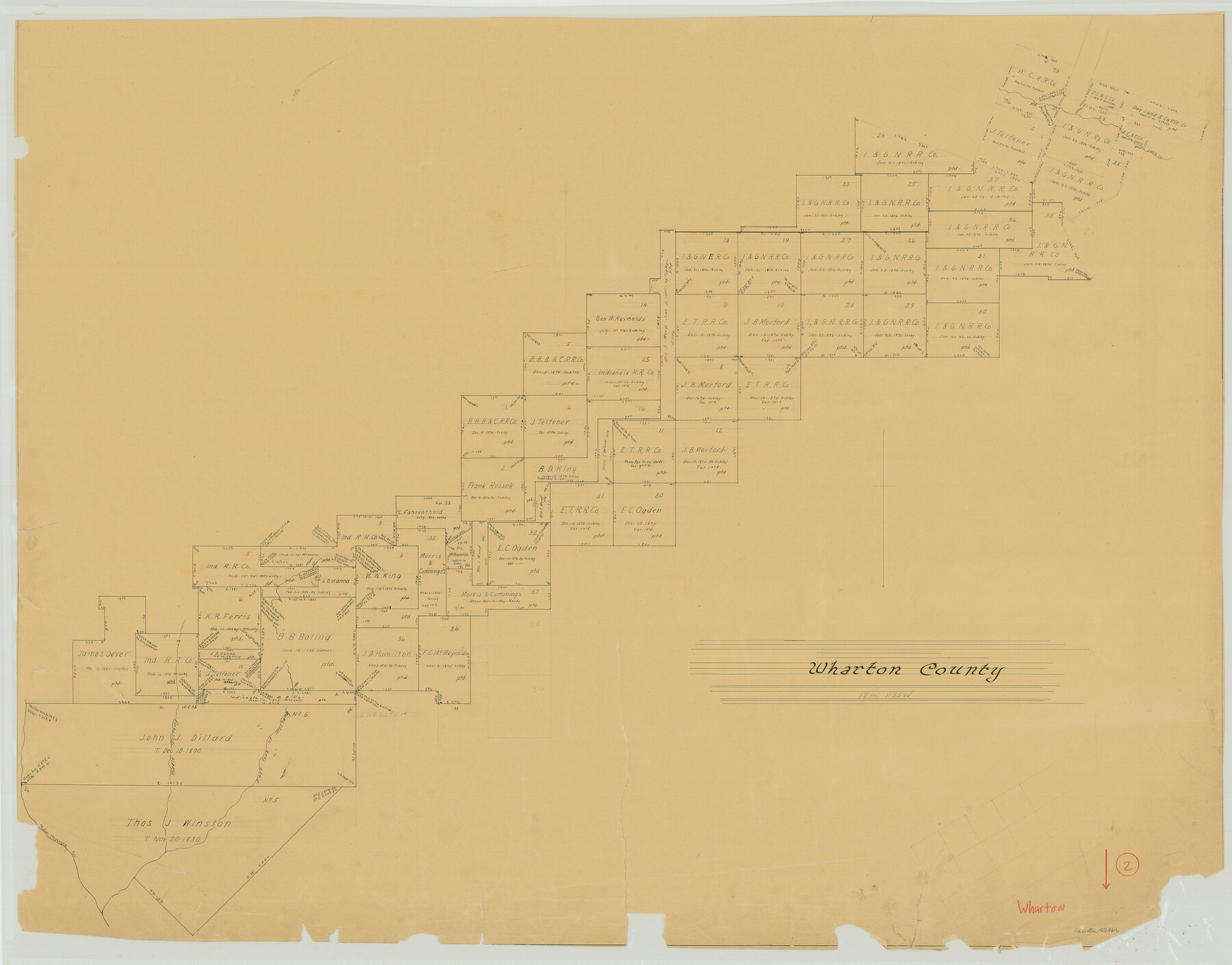
Wharton County Working Sketch 2
-
Map/Doc
72466
-
Collection
General Map Collection
-
Counties
Wharton
-
Subjects
Surveying Working Sketch
-
Height x Width
29.3 x 37.3 inches
74.4 x 94.7 cm
Part of: General Map Collection
Cameron County Aerial Photograph Index Sheet 3

Print $20.00
- Digital $50.00
Cameron County Aerial Photograph Index Sheet 3
1955
Size 21.1 x 17.4 inches
Map/Doc 83675
Map of Defunct and Ghost Counties in Texas

Print $20.00
- Digital $50.00
Map of Defunct and Ghost Counties in Texas
1939
Size 17.4 x 18.6 inches
Map/Doc 4805
Goliad County Working Sketch 19

Print $20.00
- Digital $50.00
Goliad County Working Sketch 19
1954
Size 31.5 x 31.8 inches
Map/Doc 63209
Kinney County Working Sketch 52

Print $20.00
- Digital $50.00
Kinney County Working Sketch 52
1980
Size 26.1 x 31.0 inches
Map/Doc 70234
Crockett County Rolled Sketch 52

Print $20.00
- Digital $50.00
Crockett County Rolled Sketch 52
Size 36.7 x 44.7 inches
Map/Doc 8715
Corpus Christi Pass, Texas

Print $20.00
- Digital $50.00
Corpus Christi Pass, Texas
1871
Size 26.1 x 18.3 inches
Map/Doc 72981
University Lands Blocks 21 to 26, Pecos County, Texas

Print $20.00
- Digital $50.00
University Lands Blocks 21 to 26, Pecos County, Texas
1939
Size 46.1 x 36.8 inches
Map/Doc 2416
Presidio County Rolled Sketch 30

Print $40.00
- Digital $50.00
Presidio County Rolled Sketch 30
Size 40.8 x 84.9 inches
Map/Doc 9767
Frio County Rolled Sketch 19

Print $20.00
- Digital $50.00
Frio County Rolled Sketch 19
1956
Size 35.1 x 40.4 inches
Map/Doc 8909
Map of Houston, Harris County, Texas

Print $20.00
- Digital $50.00
Map of Houston, Harris County, Texas
1900
Size 38.5 x 32.0 inches
Map/Doc 93390
Upton County Working Sketch 48

Print $20.00
- Digital $50.00
Upton County Working Sketch 48
1975
Size 29.3 x 24.3 inches
Map/Doc 69544
Guadalupe County Sketch File 15d

Print $4.00
- Digital $50.00
Guadalupe County Sketch File 15d
Size 10.1 x 8.1 inches
Map/Doc 24705
You may also like
Garza County Working Sketch 6

Print $20.00
- Digital $50.00
Garza County Working Sketch 6
1944
Size 24.8 x 20.2 inches
Map/Doc 63153
Jeff Davis County Working Sketch 1

Print $20.00
- Digital $50.00
Jeff Davis County Working Sketch 1
Size 26.6 x 19.6 inches
Map/Doc 66496

Reynolds's Political Map of the United States Designed to Exhibit the Comparative Area of the Free and Slave States and the Territory open to Slavery or Freedom by the Repeal of the Missouri Compromise

Print $20.00
- Digital $50.00
Reynolds's Political Map of the United States Designed to Exhibit the Comparative Area of the Free and Slave States and the Territory open to Slavery or Freedom by the Repeal of the Missouri Compromise
1856
Size 24.0 x 27.0 inches
Map/Doc 97115
Galveston County Sketch File 52

Print $27.00
- Digital $50.00
Galveston County Sketch File 52
1915
Size 10.1 x 12.3 inches
Map/Doc 23516
Coryell County Working Sketch 5

Print $20.00
- Digital $50.00
Coryell County Working Sketch 5
1940
Size 24.4 x 25.1 inches
Map/Doc 68212
Duval County Working Sketch 54

Print $20.00
- Digital $50.00
Duval County Working Sketch 54
1950
Size 14.1 x 19.8 inches
Map/Doc 68778
Webb County Working Sketch 69

Print $20.00
- Digital $50.00
Webb County Working Sketch 69
1968
Size 38.6 x 37.4 inches
Map/Doc 72436
Flight Mission No. CUG-3P, Frame 136, Kleberg County

Print $20.00
- Digital $50.00
Flight Mission No. CUG-3P, Frame 136, Kleberg County
1956
Size 18.5 x 22.3 inches
Map/Doc 86271
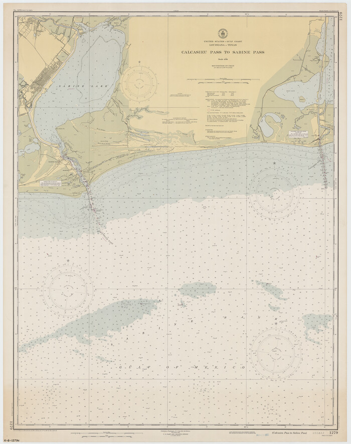
Calcasieu Pass to Sabine Pass
Print $20.00
- Digital $50.00
Calcasieu Pass to Sabine Pass
1950
Size 44.8 x 35.4 inches
Map/Doc 69808
Duval County Rolled Sketch 50

Print $20.00
- Digital $50.00
Duval County Rolled Sketch 50
1876
Size 14.2 x 11.8 inches
Map/Doc 5764
Bee County Working Sketch 30

Print $20.00
- Digital $50.00
Bee County Working Sketch 30
1950
Size 12.7 x 15.7 inches
Map/Doc 67281