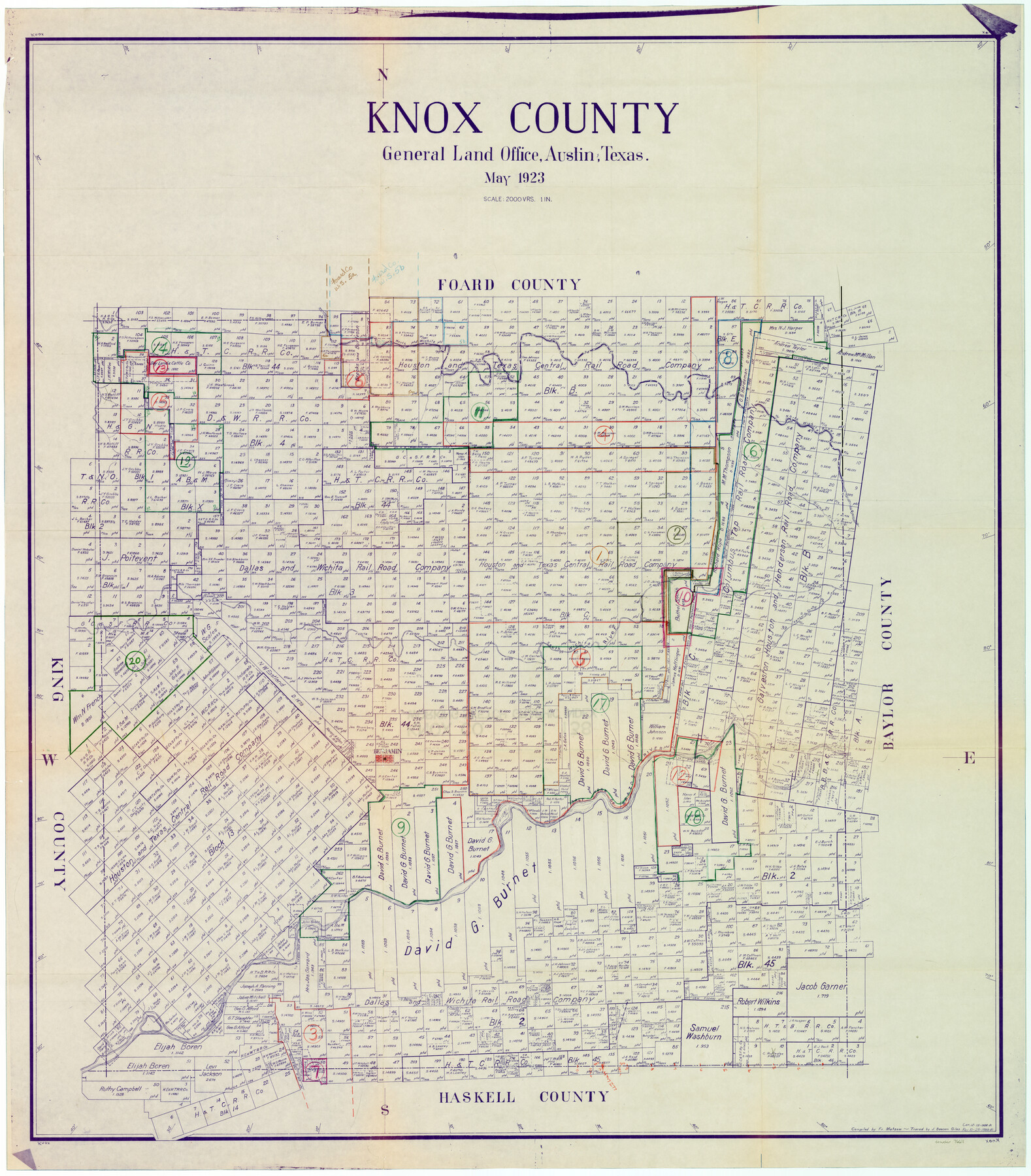
Knox County Working Sketch Graphic Index
- 
                          Map/Doc
76611
 - 
                            Collection
General Map Collection
 - 
                            Object Dates
5/1923 (Creation Date)
 - 
                            People and Organizations
Fr. Matzow (Compiler)
J. Bascom Giles (Tracer)
 - 
                            Counties
Knox
 - 
                            Subjects
County Surveying Working Sketch
 - 
                            Height x Width
44.8 x 39.4 inches
113.8 x 100.1 cm
 - 
                            Scale
1" = 2000 varas
 
Part of: General Map Collection
            Cooke County Working Sketch 28


                                            Print $20.00                    
                                             -                         Digital $50.00                                    
                Cooke County Working Sketch 28
1976
Size 28.4 x 34.1 inches
                                Map/Doc 68265
            
            Upton County Rolled Sketch 21


                                            Print $20.00                    
                                             -                         Digital $50.00                                    
                Upton County Rolled Sketch 21
1939
Size 21.5 x 37.9 inches
                                Map/Doc 8072
            
            Rusk County Working Sketch Graphic Index


                                            Print $20.00                    
                                             -                         Digital $50.00                                    
                Rusk County Working Sketch Graphic Index
1932
Size 45.6 x 34.9 inches
                                Map/Doc 76688
            
            [Sketch for Mineral Applications 26885-6 - Reagan and Crockett Cos., W. H. Bland]


                                            Print $20.00                    
                                             -                         Digital $50.00                                    
                [Sketch for Mineral Applications 26885-6 - Reagan and Crockett Cos., W. H. Bland]
1932
Size 38.4 x 9.7 inches
                                Map/Doc 3219
            
            [Surveys along San Cristoval Creek]


                                            Print $2.00                    
                                             -                         Digital $50.00                                    
                [Surveys along San Cristoval Creek]
1842
Size 9.0 x 9.3 inches
                                Map/Doc 300
            
            Duval County Sketch File 56


                                            Print $20.00                    
                                             -                         Digital $50.00                                    
                Duval County Sketch File 56
1938
Size 24.1 x 20.1 inches
                                Map/Doc 11405
            
            Bandera County Working Sketch 28


                                            Print $20.00                    
                                             -                         Digital $50.00                                    
                Bandera County Working Sketch 28
1953
Size 24.8 x 19.5 inches
                                Map/Doc 67624
            
            Maverick County Rolled Sketch 19


                                            Print $20.00                    
                                             -                         Digital $50.00                                    
                Maverick County Rolled Sketch 19
1955
Size 33.5 x 44.1 inches
                                Map/Doc 9494
            
            San Patricio County Rolled Sketch 29B


                                            Print $20.00                    
                                             -                         Digital $50.00                                    
                San Patricio County Rolled Sketch 29B
Size 25.8 x 31.0 inches
                                Map/Doc 7582
            
            Connected Map of Austin's Colony (1892 tracing)


                                            Print $40.00                    
                                             -                         Digital $50.00                                    
                Connected Map of Austin's Colony (1892 tracing)
1837
Size 90.8 x 46.5 inches
                                Map/Doc 93359
            
            Edwards County Working Sketch 90


                                            Print $20.00                    
                                             -                         Digital $50.00                                    
                Edwards County Working Sketch 90
1966
Size 33.6 x 27.2 inches
                                Map/Doc 68966
            
            Supreme Court of the United States, October Term, 1923, No. 15, Original - The State of Oklahoma, Complainant vs. The State of Texas, Defendant, The United States, Intervener; Report of the Boundary Commissioners


                                            Print $20.00                    
                                             -                         Digital $50.00                                    
                Supreme Court of the United States, October Term, 1923, No. 15, Original - The State of Oklahoma, Complainant vs. The State of Texas, Defendant, The United States, Intervener; Report of the Boundary Commissioners
1923
Size 39.4 x 39.6 inches
                                Map/Doc 75116
            You may also like
            [Map of] North America


                                            Print $3.00                    
                                             -                         Digital $50.00                                    
                [Map of] North America
1834
Size 11.0 x 8.5 inches
                                Map/Doc 88884
            
            From Citizens of Shelby County for the Creation of a New County to be Called Caddo, April 7, 1838


                                            Print $20.00                    
                                    
                From Citizens of Shelby County for the Creation of a New County to be Called Caddo, April 7, 1838
2020
Size 25.5 x 21.7 inches
                                Map/Doc 96377
            
            Hardin County


                                            Print $20.00                    
                                             -                         Digital $50.00                                    
                Hardin County
1940
Size 40.7 x 37.7 inches
                                Map/Doc 77303
            
            Wise County Sketch File 22


                                            Print $4.00                    
                                             -                         Digital $50.00                                    
                Wise County Sketch File 22
1860
Size 7.5 x 7.2 inches
                                Map/Doc 40566
            
            Hutchinson County Sketch File 4a


                                            Print $7.00                    
                                             -                         Digital $50.00                                    
                Hutchinson County Sketch File 4a
Size 25.9 x 43.8 inches
                                Map/Doc 10625
            
            Cherokee County Boundary File 6 and 15


                                            Print $8.00                    
                                             -                         Digital $50.00                                    
                Cherokee County Boundary File 6 and 15
Size 8.3 x 6.7 inches
                                Map/Doc 51301
            
            Morris County Rolled Sketch 2A


                                            Print $20.00                    
                                             -                         Digital $50.00                                    
                Morris County Rolled Sketch 2A
Size 22.2 x 17.3 inches
                                Map/Doc 10265
            
            Tarrant County Rolled Sketch 2


                                            Print $40.00                    
                                             -                         Digital $50.00                                    
                Tarrant County Rolled Sketch 2
1955
Size 96.5 x 23.5 inches
                                Map/Doc 9984
            
            Brewster County Rolled Sketch 22B


                                            Print $20.00                    
                                             -                         Digital $50.00                                    
                Brewster County Rolled Sketch 22B
1910
Size 24.5 x 19.5 inches
                                Map/Doc 5203
            
            Map Exhibiting the Leading Transportation Lines of the Pacific Coast, prepared for the report of the Chief of the Bureau of Statistics on the internal commerce of the United States


                                            Print $20.00                    
                                             -                         Digital $50.00                                    
                Map Exhibiting the Leading Transportation Lines of the Pacific Coast, prepared for the report of the Chief of the Bureau of Statistics on the internal commerce of the United States
1887
Size 22.2 x 24.5 inches
                                Map/Doc 95905
            
            Chambers County Rolled Sketch 30


                                            Print $20.00                    
                                             -                         Digital $50.00                                    
                Chambers County Rolled Sketch 30
1952
Size 26.7 x 37.9 inches
                                Map/Doc 5430
            
            Cameron County Rolled Sketch 19


                                            Print $2.00                    
                                             -                         Digital $50.00                                    
                Cameron County Rolled Sketch 19
Size 7.1 x 5.7 inches
                                Map/Doc 5466