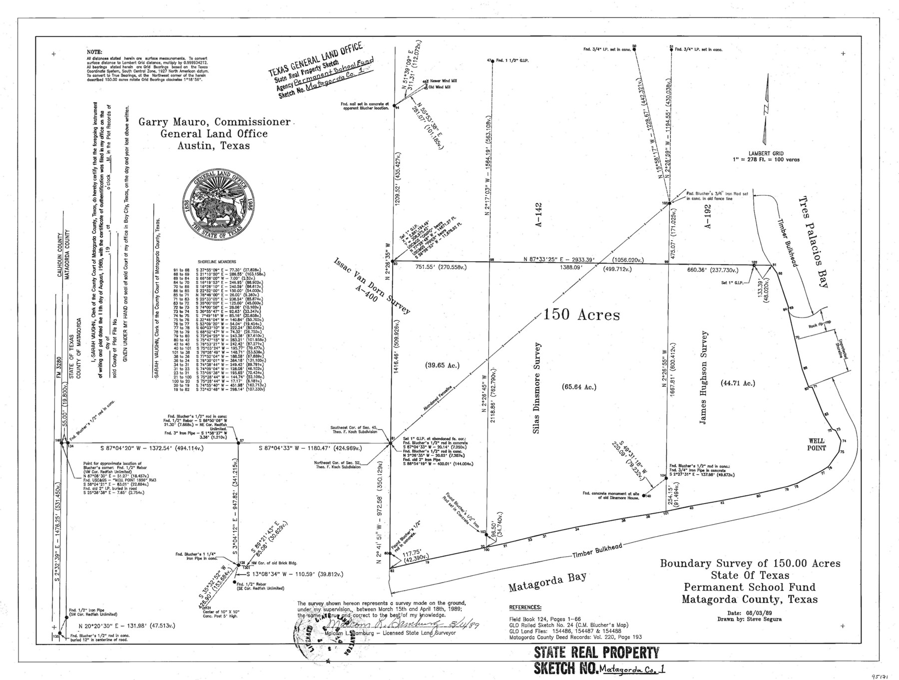
Matagorda County State Real Property Sketch 1
Boundary Survey of 150.00 acres
-
Map/Doc
95171
-
Collection
General Map Collection
-
Object Dates
1989/8/3 (Creation Date)
-
People and Organizations
Steve Segura (Draftsman)
Malcom L. Bamburg (Surveyor/Engineer)
-
Counties
Matagorda
-
Subjects
State Real Property
-
Height x Width
19.1 x 25.2 inches
48.5 x 64.0 cm
-
Medium
mylar, print
-
Scale
1"=278 Ft.=100 varas
Part of: General Map Collection
Liberty County Working Sketch 17

Print $20.00
- Digital $50.00
Liberty County Working Sketch 17
1934
Size 34.5 x 24.0 inches
Map/Doc 70476
Cochran County Working Sketch 1

Print $20.00
- Digital $50.00
Cochran County Working Sketch 1
1940
Size 21.1 x 35.9 inches
Map/Doc 68012
Kinney County Working Sketch 2

Print $20.00
- Digital $50.00
Kinney County Working Sketch 2
1886
Size 20.0 x 20.4 inches
Map/Doc 70184
Crockett County Working Sketch 59

Print $20.00
- Digital $50.00
Crockett County Working Sketch 59
1955
Size 46.1 x 29.3 inches
Map/Doc 68392
Glasscock County Sketch File 26

Print $20.00
- Digital $50.00
Glasscock County Sketch File 26
1951
Size 16.1 x 28.3 inches
Map/Doc 11567
Duval County Sketch File 18

Print $40.00
- Digital $50.00
Duval County Sketch File 18
Size 12.7 x 15.8 inches
Map/Doc 21314
Calhoun County Rolled Sketch 30

Print $20.00
- Digital $50.00
Calhoun County Rolled Sketch 30
1974
Size 18.6 x 27.6 inches
Map/Doc 5493
[St. L. S-W. Ry. of Texas Map of Lufkin Branch in Cherokee County Texas]
![64018, [St. L. S-W. Ry. of Texas Map of Lufkin Branch in Cherokee County Texas], General Map Collection](https://historictexasmaps.com/wmedia_w700/maps/64018.tif.jpg)
Print $40.00
- Digital $50.00
[St. L. S-W. Ry. of Texas Map of Lufkin Branch in Cherokee County Texas]
1912
Size 22.3 x 121.1 inches
Map/Doc 64018
Hopkins County

Print $20.00
- Digital $50.00
Hopkins County
1942
Size 44.1 x 40.9 inches
Map/Doc 73183
Presidio County Sketch File 57

Print $8.00
- Digital $50.00
Presidio County Sketch File 57
1938
Size 14.3 x 8.9 inches
Map/Doc 34624
Presidio County Sketch File 105

Print $20.00
- Digital $50.00
Presidio County Sketch File 105
Size 15.6 x 42.6 inches
Map/Doc 11726
Gillespie County Sketch File 11

Print $4.00
- Digital $50.00
Gillespie County Sketch File 11
1877
Size 8.3 x 12.8 inches
Map/Doc 24149
You may also like
Flight Mission No. BRE-1P, Frame 98, Nueces County

Print $20.00
- Digital $50.00
Flight Mission No. BRE-1P, Frame 98, Nueces County
1956
Size 18.4 x 22.1 inches
Map/Doc 86669
Travis County Sketch File 26

Print $4.00
- Digital $50.00
Travis County Sketch File 26
1876
Size 12.9 x 8.5 inches
Map/Doc 38336
Map of Jasper County

Print $20.00
- Digital $50.00
Map of Jasper County
1839
Size 41.6 x 28.5 inches
Map/Doc 3711
Working Sketch Hemphill County

Print $20.00
- Digital $50.00
Working Sketch Hemphill County
1910
Size 6.9 x 39.1 inches
Map/Doc 90730
Real County Rolled Sketch 18

Print $20.00
- Digital $50.00
Real County Rolled Sketch 18
Size 22.2 x 28.2 inches
Map/Doc 7461
Flight Mission No. DCL-7C, Frame 62, Kenedy County

Print $20.00
- Digital $50.00
Flight Mission No. DCL-7C, Frame 62, Kenedy County
1943
Size 15.4 x 15.3 inches
Map/Doc 86050
Cogdell Ranch Kent County, Texas

Print $20.00
- Digital $50.00
Cogdell Ranch Kent County, Texas
1950
Size 24.8 x 13.5 inches
Map/Doc 92189
Map of Presidio County

Print $40.00
- Digital $50.00
Map of Presidio County
1895
Size 53.0 x 38.6 inches
Map/Doc 3968
Dickens County Sketch File 14a

Print $20.00
- Digital $50.00
Dickens County Sketch File 14a
Size 18.2 x 16.5 inches
Map/Doc 11321
King County, Texas

Print $20.00
- Digital $50.00
King County, Texas
1880
Size 20.0 x 19.4 inches
Map/Doc 737
Howard County Sketch File 8

Print $3.00
- Digital $50.00
Howard County Sketch File 8
Size 20.8 x 18.7 inches
Map/Doc 11796
Current Miscellaneous File 26

Print $4.00
- Digital $50.00
Current Miscellaneous File 26
1952
Size 10.7 x 8.3 inches
Map/Doc 73907