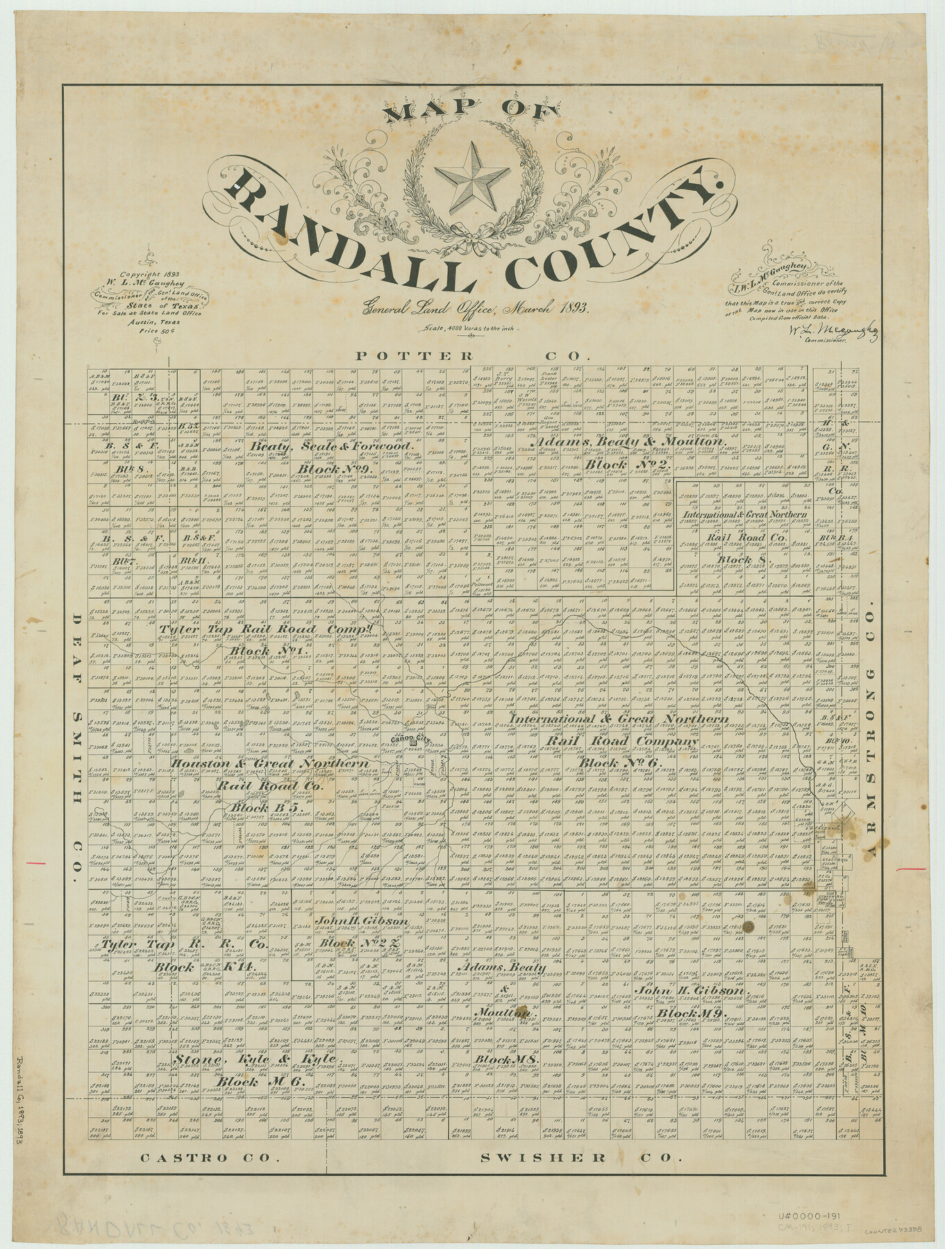
Map of Randall County
-
Map/Doc
73338
-
Collection
General Map Collection
-
Object Dates
1893 (Creation Date)
-
People and Organizations
Texas General Land Office (Publisher)
W.L. McGaughey (GLO Commissioner)
-
Counties
Randall
-
Subjects
County
-
Height x Width
26.5 x 20.0 inches
67.3 x 50.8 cm
-
Comments
Copyrighted 1893.
Part of: General Map Collection
Willacy County Boundary File 2

Print $16.00
- Digital $50.00
Willacy County Boundary File 2
Size 11.0 x 8.7 inches
Map/Doc 59967
[Sketch for Mineral Application 21493 - Clay County]
![65625, [Sketch for Mineral Application 21493 - Clay County], General Map Collection](https://historictexasmaps.com/wmedia_w700/maps/65625-1.tif.jpg)
Print $40.00
- Digital $50.00
[Sketch for Mineral Application 21493 - Clay County]
Size 62.4 x 34.8 inches
Map/Doc 65625

Angelina County Working Sketch 25

Print $20.00
- Digital $50.00
Angelina County Working Sketch 25
1954
Size 25.0 x 17.5 inches
Map/Doc 67107
Midland County Working Sketch 3

Print $20.00
- Digital $50.00
Midland County Working Sketch 3
Size 19.5 x 35.2 inches
Map/Doc 70983
Hardin County Working Sketch 42

Print $20.00
- Digital $50.00
Hardin County Working Sketch 42
1917
Size 16.2 x 22.1 inches
Map/Doc 63441
Menard County Sketch File 28

Print $8.00
- Digital $50.00
Menard County Sketch File 28
1955
Size 11.0 x 8.6 inches
Map/Doc 31567
Flight Mission No. CRE-2R, Frame 84, Jackson County

Print $20.00
- Digital $50.00
Flight Mission No. CRE-2R, Frame 84, Jackson County
1956
Size 16.1 x 15.9 inches
Map/Doc 85356
Culberson County Sketch File 11a

Print $4.00
- Digital $50.00
Culberson County Sketch File 11a
1926
Size 14.3 x 8.7 inches
Map/Doc 20172
Clay County Working Sketch 14

Print $20.00
- Digital $50.00
Clay County Working Sketch 14
1984
Size 46.9 x 34.5 inches
Map/Doc 68037
Kendall County Working Sketch 29

Print $20.00
- Digital $50.00
Kendall County Working Sketch 29
2025
Map/Doc 97408
Dickens County Working Sketch 15

Print $20.00
- Digital $50.00
Dickens County Working Sketch 15
2011
Size 28.8 x 28.6 inches
Map/Doc 90067
You may also like
Jasper County Working Sketch 35

Print $20.00
- Digital $50.00
Jasper County Working Sketch 35
2008
Size 28.5 x 40.0 inches
Map/Doc 88733
Burnet County Boundary File 7a

Print $30.00
- Digital $50.00
Burnet County Boundary File 7a
Size 14.1 x 8.5 inches
Map/Doc 50902
Flight Mission No. DQN-2K, Frame 65, Calhoun County

Print $20.00
- Digital $50.00
Flight Mission No. DQN-2K, Frame 65, Calhoun County
1953
Size 18.5 x 22.2 inches
Map/Doc 84257
Flight Mission No. DQN-2K, Frame 90, Calhoun County

Print $20.00
- Digital $50.00
Flight Mission No. DQN-2K, Frame 90, Calhoun County
1953
Size 18.4 x 22.3 inches
Map/Doc 84280
Fort Bend County State Real Property Sketch 2

Print $40.00
- Digital $50.00
Fort Bend County State Real Property Sketch 2
1986
Size 34.8 x 43.4 inches
Map/Doc 61676

[Blocks 36 and 37, Townships 1S-5S]
![93213, [Blocks 36 and 37, Townships 1S-5S], Twichell Survey Records](https://historictexasmaps.com/wmedia_w700/maps/93213-1.tif.jpg)
Print $40.00
- Digital $50.00
[Blocks 36 and 37, Townships 1S-5S]
Size 28.9 x 83.7 inches
Map/Doc 93213
Palo Pinto County Working Sketch 9

Print $20.00
- Digital $50.00
Palo Pinto County Working Sketch 9
1922
Map/Doc 71392
Working Sketch Hemphill County

Print $20.00
- Digital $50.00
Working Sketch Hemphill County
1910
Size 6.9 x 39.1 inches
Map/Doc 90730
Stephens County Working Sketch 22

Print $40.00
- Digital $50.00
Stephens County Working Sketch 22
1975
Size 32.9 x 49.0 inches
Map/Doc 63965
King County Sketch File 4

Print $22.00
- Digital $50.00
King County Sketch File 4
Size 8.8 x 14.2 inches
Map/Doc 29022
Liberty County Working Sketch 43

Print $20.00
- Digital $50.00
Liberty County Working Sketch 43
1953
Size 30.6 x 43.7 inches
Map/Doc 70502