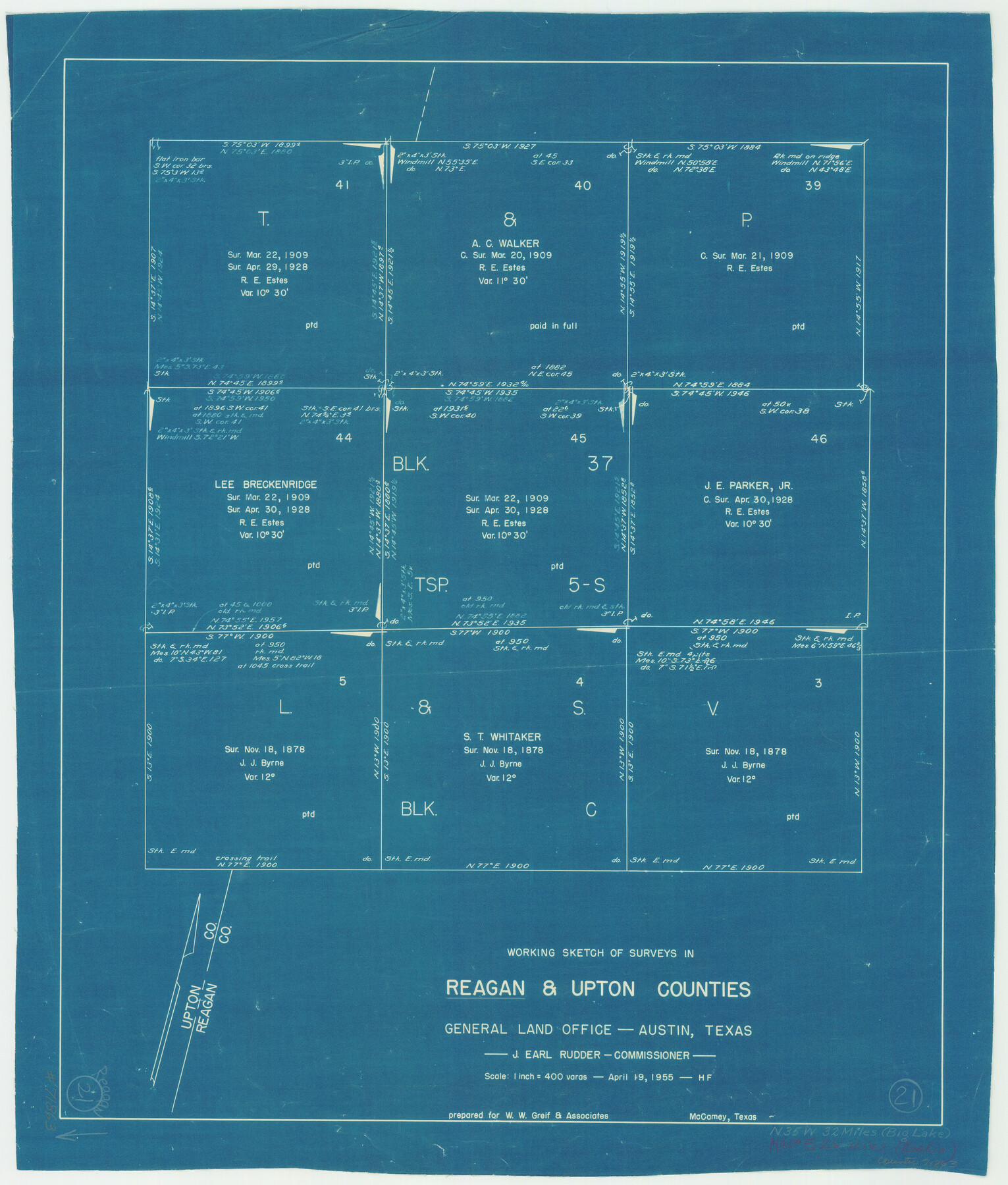
Reagan County Working Sketch 21
-
Map/Doc
71863
-
Collection
General Map Collection
-
Object Dates
4/19/1955 (Creation Date)
-
People and Organizations
Herman Forbes (Draftsman)
-
Counties
Reagan Upton
-
Subjects
Surveying Working Sketch
-
Height x Width
23.4 x 19.9 inches
59.4 x 50.6 cm
-
Scale
1" = 400 varas
Part of: General Map Collection
Hamilton County Boundary File 1

Print $22.00
- Digital $50.00
Hamilton County Boundary File 1
Size 8.6 x 8.1 inches
Map/Doc 54183
Presidio County Working Sketch 130

Print $20.00
- Digital $50.00
Presidio County Working Sketch 130
1989
Size 22.1 x 43.1 inches
Map/Doc 71808
Map of Part of Texas Prison System, Blue Ridge State Farm near Camp No. 1 Showing Buildings and Property Lines

Print $20.00
- Digital $50.00
Map of Part of Texas Prison System, Blue Ridge State Farm near Camp No. 1 Showing Buildings and Property Lines
Size 20.3 x 25.4 inches
Map/Doc 62980
Concho County Sketch File 37

Print $20.00
- Digital $50.00
Concho County Sketch File 37
1938
Size 18.7 x 29.1 inches
Map/Doc 11162
Galveston County NRC Article 33.136 Sketch 98

Print $32.00
Galveston County NRC Article 33.136 Sketch 98
2024
Map/Doc 97409
Map of the State University & Public School Lands in Reeves and El Paso Cos.

Print $40.00
- Digital $50.00
Map of the State University & Public School Lands in Reeves and El Paso Cos.
1884
Size 39.1 x 56.3 inches
Map/Doc 2434
Maps of Gulf Intracoastal Waterway, Texas - Sabine River to the Rio Grande and connecting waterways including ship channels

Print $20.00
- Digital $50.00
Maps of Gulf Intracoastal Waterway, Texas - Sabine River to the Rio Grande and connecting waterways including ship channels
1966
Size 14.6 x 22.3 inches
Map/Doc 61950
Tyler County Sketch File 6-2

Print $20.00
- Digital $50.00
Tyler County Sketch File 6-2
1861
Size 16.8 x 22.5 inches
Map/Doc 12498
Coke County Working Sketch 26

Print $20.00
- Digital $50.00
Coke County Working Sketch 26
1961
Size 29.1 x 31.2 inches
Map/Doc 68063
Flight Mission No. DCL-5C, Frame 50, Kenedy County

Print $20.00
- Digital $50.00
Flight Mission No. DCL-5C, Frame 50, Kenedy County
1943
Size 18.6 x 22.4 inches
Map/Doc 85846
Childress County Rolled Sketch 18

Print $20.00
- Digital $50.00
Childress County Rolled Sketch 18
1913
Size 17.6 x 39.0 inches
Map/Doc 5451
Railroad Track Map, H&TCRRCo., Falls County, Texas

Print $4.00
- Digital $50.00
Railroad Track Map, H&TCRRCo., Falls County, Texas
1918
Size 11.4 x 18.7 inches
Map/Doc 62851
You may also like
Pecos County Working Sketch 66

Print $20.00
- Digital $50.00
Pecos County Working Sketch 66
1955
Size 25.8 x 21.2 inches
Map/Doc 71538
Liberty County Rolled Sketch JP2

Print $40.00
- Digital $50.00
Liberty County Rolled Sketch JP2
1935
Size 52.2 x 12.7 inches
Map/Doc 81403
Borden County Sketch File 12

Print $24.00
- Digital $50.00
Borden County Sketch File 12
Size 10.8 x 9.1 inches
Map/Doc 14732
Upton County Boundary File 1b

Print $28.00
- Digital $50.00
Upton County Boundary File 1b
Size 13.5 x 9.1 inches
Map/Doc 59512
Gonzales County, Texas

Print $20.00
- Digital $50.00
Gonzales County, Texas
1880
Size 27.3 x 24.7 inches
Map/Doc 447
Foard County Boundary File 4

Print $24.00
- Digital $50.00
Foard County Boundary File 4
Size 14.2 x 8.8 inches
Map/Doc 53524
[Worksheets related to the Wilson Strickland survey and vicinity]
![91281, [Worksheets related to the Wilson Strickland survey and vicinity], Twichell Survey Records](https://historictexasmaps.com/wmedia_w700/maps/91281-1.tif.jpg)
Print $20.00
- Digital $50.00
[Worksheets related to the Wilson Strickland survey and vicinity]
Size 22.6 x 10.2 inches
Map/Doc 91281
Andrews County Working Sketch 8

Print $20.00
- Digital $50.00
Andrews County Working Sketch 8
1954
Size 18.2 x 14.9 inches
Map/Doc 67054
Upton County Rolled Sketch 38

Print $20.00
- Digital $50.00
Upton County Rolled Sketch 38
1953
Size 21.1 x 28.0 inches
Map/Doc 8078
Map of Texas with population and location of principal towns and cities according to latest reliable statistics

Print $20.00
- Digital $50.00
Map of Texas with population and location of principal towns and cities according to latest reliable statistics
1908
Size 18.6 x 20.5 inches
Map/Doc 95872
Harris County Rolled Sketch 64

Print $20.00
- Digital $50.00
Harris County Rolled Sketch 64
1936
Size 35.0 x 40.3 inches
Map/Doc 9123
Newton County Aerial Photograph Index Sheet 5

Print $20.00
- Digital $50.00
Newton County Aerial Photograph Index Sheet 5
1953
Size 24.1 x 17.7 inches
Map/Doc 83734