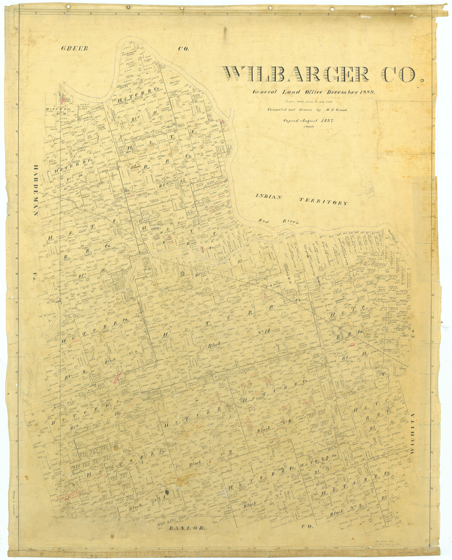
Wilbarger Co.
-
Map/Doc
63124
-
Collection
General Map Collection
-
Object Dates
1889 (Creation Date)
-
People and Organizations
Texas General Land Office (Publisher)
M.E. Groos (Draftsman)
M.E. Groos (Compiler)
-
Counties
Wilbarger
-
Subjects
County
-
Height x Width
48.2 x 39.0 inches
122.4 x 99.1 cm
-
Comments
Copied in August 1897 by Appell.
Part of: General Map Collection
Flight Mission No. CGI-2N, Frame 185, Cameron County

Print $20.00
- Digital $50.00
Flight Mission No. CGI-2N, Frame 185, Cameron County
1954
Size 18.5 x 22.2 inches
Map/Doc 84545
Sutton County Sketch File 49

Print $6.00
- Digital $50.00
Sutton County Sketch File 49
Size 13.6 x 8.9 inches
Map/Doc 37523
Copy of Surveyor's Field Book, Morris Browning - In Blocks 7, 5 & 4, I&GNRRCo., Hutchinson and Carson Counties, Texas

Print $2.00
- Digital $50.00
Copy of Surveyor's Field Book, Morris Browning - In Blocks 7, 5 & 4, I&GNRRCo., Hutchinson and Carson Counties, Texas
1888
Size 7.0 x 8.8 inches
Map/Doc 62259
No. 2 Chart of Corpus Christi Pass, Texas

Print $20.00
- Digital $50.00
No. 2 Chart of Corpus Christi Pass, Texas
1878
Size 18.3 x 27.2 inches
Map/Doc 73028
Houston County Working Sketch 5

Print $20.00
- Digital $50.00
Houston County Working Sketch 5
Size 24.9 x 28.1 inches
Map/Doc 66235
Brewster County Rolled Sketch 106

Print $20.00
- Digital $50.00
Brewster County Rolled Sketch 106
1958
Size 20.7 x 24.6 inches
Map/Doc 5258
Haskell County Sketch File 1

Print $20.00
- Digital $50.00
Haskell County Sketch File 1
1856
Size 19.9 x 10.6 inches
Map/Doc 11738
Howard County Sketch File 7

Print $20.00
- Digital $50.00
Howard County Sketch File 7
Size 21.7 x 13.8 inches
Map/Doc 11795
Jefferson County NRC Article 33.136 Sketch 2

Print $20.00
- Digital $50.00
Jefferson County NRC Article 33.136 Sketch 2
2002
Size 24.3 x 35.9 inches
Map/Doc 77048
Edwards County Working Sketch 70

Print $20.00
- Digital $50.00
Edwards County Working Sketch 70
1957
Size 22.5 x 22.4 inches
Map/Doc 68946
Fannin County No. 2 McClure & M. H. Wright's map, Sulphur

Print $2.00
- Digital $50.00
Fannin County No. 2 McClure & M. H. Wright's map, Sulphur
1844
Size 8.4 x 8.1 inches
Map/Doc 69732
Dimmit County Working Sketch 39

Print $20.00
- Digital $50.00
Dimmit County Working Sketch 39
1967
Size 25.5 x 30.0 inches
Map/Doc 68700
You may also like
Flight Mission No. DQN-6K, Frame 75, Calhoun County

Print $20.00
- Digital $50.00
Flight Mission No. DQN-6K, Frame 75, Calhoun County
1953
Size 18.6 x 22.2 inches
Map/Doc 84447
[Townships 1 through 5 North, Blocks 34, 35, and 36]
![92587, [Townships 1 through 5 North, Blocks 34, 35, and 36], Twichell Survey Records](https://historictexasmaps.com/wmedia_w700/maps/92587-1.tif.jpg)
Print $20.00
- Digital $50.00
[Townships 1 through 5 North, Blocks 34, 35, and 36]
Size 41.7 x 21.4 inches
Map/Doc 92587
Flight Mission No. CLL-1N, Frame 29, Willacy County

Print $20.00
- Digital $50.00
Flight Mission No. CLL-1N, Frame 29, Willacy County
1954
Size 18.5 x 22.1 inches
Map/Doc 87010
Location from Del Rio to Johnstone, Southern Pacific Railway Co.

Print $20.00
- Digital $50.00
Location from Del Rio to Johnstone, Southern Pacific Railway Co.
Size 13.3 x 44.3 inches
Map/Doc 64290
Bell County Working Sketch 6

Print $20.00
- Digital $50.00
Bell County Working Sketch 6
1946
Size 24.9 x 33.6 inches
Map/Doc 67346
Map of Texas, compiled from surveys on record in the General Land Office of the Republic to the year 1839

Print $20.00
- Digital $50.00
Map of Texas, compiled from surveys on record in the General Land Office of the Republic to the year 1839
1839
Size 33.1 x 25.8 inches
Map/Doc 93986
Map of Blanco County

Print $20.00
- Digital $50.00
Map of Blanco County
1878
Size 19.0 x 28.0 inches
Map/Doc 3305
[Sketch showing surveys in Blocks 70, 71 and 72 surrounding the town of Toyah]
![91835, [Sketch showing surveys in Blocks 70, 71 and 72 surrounding the town of Toyah], Twichell Survey Records](https://historictexasmaps.com/wmedia_w700/maps/91835-1.tif.jpg)
Print $20.00
- Digital $50.00
[Sketch showing surveys in Blocks 70, 71 and 72 surrounding the town of Toyah]
Size 44.1 x 24.0 inches
Map/Doc 91835
Kendall County Rolled Sketch 9

Print $20.00
- Digital $50.00
Kendall County Rolled Sketch 9
1990
Size 32.8 x 24.3 inches
Map/Doc 95298
Val Verde County Sketch File Z14

Print $20.00
- Digital $50.00
Val Verde County Sketch File Z14
1899
Size 22.1 x 20.6 inches
Map/Doc 12556
Blanco County Sketch File 22

Print $4.00
- Digital $50.00
Blanco County Sketch File 22
1884
Size 8.7 x 15.5 inches
Map/Doc 14604
Menard County Rolled Sketch 6

Print $20.00
- Digital $50.00
Menard County Rolled Sketch 6
Size 17.3 x 21.2 inches
Map/Doc 6755