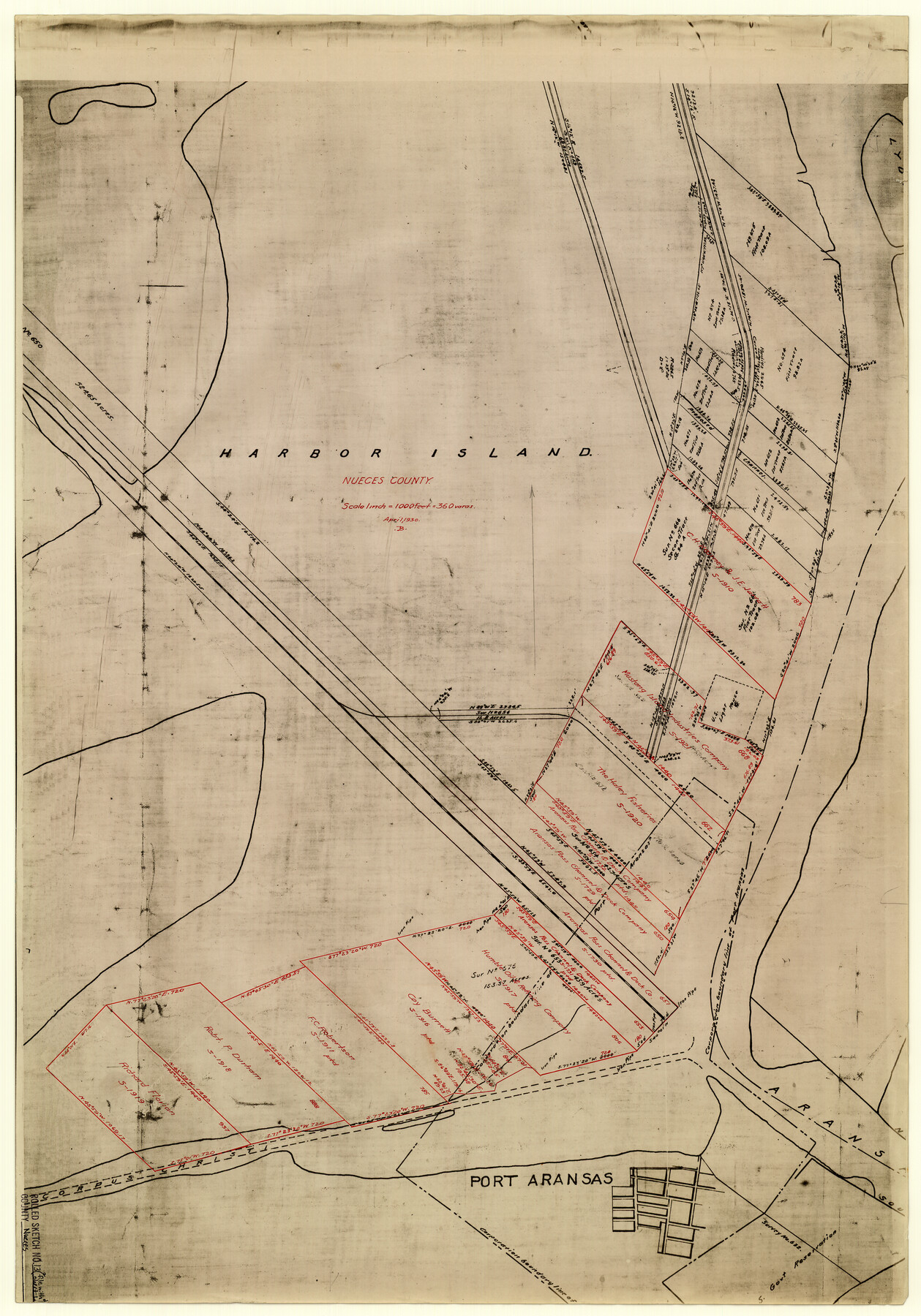
Nueces County Rolled Sketch 13
[Sketch of south part of Harbor Island]
-
Map/Doc
6869
-
Collection
General Map Collection
-
Object Dates
1930 (Creation Date)
-
Counties
Nueces
-
Subjects
Surveying Rolled Sketch
-
Height x Width
26.5 x 18.5 inches
67.3 x 47.0 cm
-
Medium
van dyke/brownline/sepia
-
Scale
1" = 360 varas
Part of: General Map Collection
Brewster County Rolled Sketch 114

Print $20.00
- Digital $50.00
Brewster County Rolled Sketch 114
1964
Size 11.1 x 18.4 inches
Map/Doc 5270

Presidio County Sketch File 58a

Print $14.00
- Digital $50.00
Presidio County Sketch File 58a
1980
Size 11.2 x 8.8 inches
Map/Doc 34628
Flight Mission No. CGI-3N, Frame 137, Cameron County

Print $20.00
- Digital $50.00
Flight Mission No. CGI-3N, Frame 137, Cameron County
1954
Size 18.6 x 22.2 inches
Map/Doc 84610
Sabine County

Print $20.00
- Digital $50.00
Sabine County
1920
Size 45.7 x 36.1 inches
Map/Doc 95631
Rusk County Sketch File 9

Print $4.00
Rusk County Sketch File 9
1849
Size 8.4 x 8.2 inches
Map/Doc 35505
Brooks County Working Sketch 3

Print $20.00
- Digital $50.00
Brooks County Working Sketch 3
Size 16.2 x 21.3 inches
Map/Doc 67787
Ector County Working Sketch 32

Print $20.00
- Digital $50.00
Ector County Working Sketch 32
1981
Size 26.2 x 17.0 inches
Map/Doc 68875
Falls County Sketch File 11a

Print $8.00
- Digital $50.00
Falls County Sketch File 11a
1871
Size 12.9 x 8.2 inches
Map/Doc 22358
Nueces River, Corpus Christi Sheet No. 6

Print $6.00
- Digital $50.00
Nueces River, Corpus Christi Sheet No. 6
1938
Size 31.3 x 31.0 inches
Map/Doc 65095
Rio Grande, La Puerta Sheet

Print $20.00
- Digital $50.00
Rio Grande, La Puerta Sheet
1931
Size 29.7 x 43.4 inches
Map/Doc 65106
Map of Nolan County

Print $20.00
- Digital $50.00
Map of Nolan County
1896
Size 28.8 x 23.5 inches
Map/Doc 3915
You may also like
Wilson County Sketch File 4

Print $28.00
- Digital $50.00
Wilson County Sketch File 4
1851
Size 8.4 x 7.7 inches
Map/Doc 40404
Flight Mission No. DQN-7K, Frame 8, Calhoun County

Print $20.00
- Digital $50.00
Flight Mission No. DQN-7K, Frame 8, Calhoun County
1953
Size 18.5 x 22.2 inches
Map/Doc 84459
Val Verde County Working Sketch 20

Print $20.00
- Digital $50.00
Val Verde County Working Sketch 20
1929
Size 30.5 x 20.2 inches
Map/Doc 72155
[I. M. Bolton, L. S. Thacker, and R. C. Poteet Subdivisions]
![92577, [I. M. Bolton, L. S. Thacker, and R. C. Poteet Subdivisions], Twichell Survey Records](https://historictexasmaps.com/wmedia_w700/maps/92577-1.tif.jpg)
Print $20.00
- Digital $50.00
[I. M. Bolton, L. S. Thacker, and R. C. Poteet Subdivisions]
1924
Size 18.8 x 24.5 inches
Map/Doc 92577
Webb County Rolled Sketch 47

Print $20.00
- Digital $50.00
Webb County Rolled Sketch 47
Size 23.5 x 31.7 inches
Map/Doc 8203
Gray County Sketch File 9

Print $38.00
- Digital $50.00
Gray County Sketch File 9
1889
Size 11.2 x 8.4 inches
Map/Doc 24426
English Field Notes of the Spanish Archives - Book A-B

English Field Notes of the Spanish Archives - Book A-B
1835
Map/Doc 96540
Sketch in Terry & Yoakum Counties

Print $20.00
- Digital $50.00
Sketch in Terry & Yoakum Counties
1945
Size 21.8 x 40.0 inches
Map/Doc 92854
Lamar County Sketch File 13

Print $2.00
- Digital $50.00
Lamar County Sketch File 13
1943
Size 10.9 x 8.0 inches
Map/Doc 29307
Map of West Part of Galveston County, Texas

Print $20.00
- Digital $50.00
Map of West Part of Galveston County, Texas
1880
Size 28.6 x 21.9 inches
Map/Doc 716
Real County Working Sketch 85

Print $20.00
- Digital $50.00
Real County Working Sketch 85
1988
Size 27.0 x 30.0 inches
Map/Doc 71977
Dawson County Working Sketch 21

Print $20.00
- Digital $50.00
Dawson County Working Sketch 21
1963
Size 24.0 x 24.0 inches
Map/Doc 68565