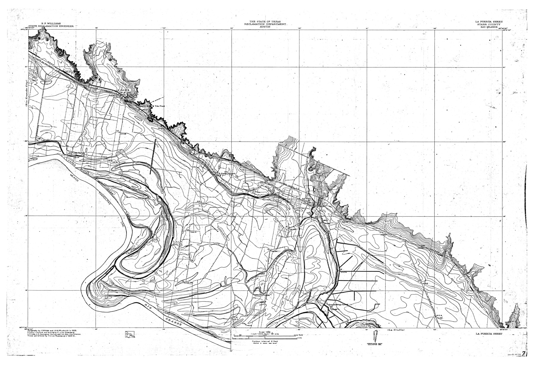
Rio Grande, La Puerta Sheet
-
Map/Doc
65106
-
Collection
General Map Collection
-
Object Dates
1931 (Creation Date)
-
People and Organizations
Texas State Reclamation Department (Publisher)
H.U. von Rosenberg (Compiler)
H.U. von Rosenberg (Draftsman)
E.J. von Rosenberg (Surveyor/Engineer)
A.W. Plushnick (Surveyor/Engineer)
C.R. Hale (Surveyor/Engineer)
-
Counties
Starr
-
Subjects
River Surveys Topographic
-
Height x Width
29.7 x 43.4 inches
75.4 x 110.2 cm
-
Comments
La Puerta Sheet located east of the La Puerta Sheet and north of the La Grulla Sheet.
Part of: General Map Collection
Flight Mission No. DAG-24K, Frame 38, Matagorda County

Print $20.00
- Digital $50.00
Flight Mission No. DAG-24K, Frame 38, Matagorda County
1953
Size 18.5 x 15.8 inches
Map/Doc 86525
Map of Robertson County

Print $20.00
- Digital $50.00
Map of Robertson County
1873
Size 28.0 x 21.6 inches
Map/Doc 83003
Fisher County Sketch File 15a

Print $10.00
- Digital $50.00
Fisher County Sketch File 15a
1901
Size 7.6 x 9.0 inches
Map/Doc 22578
Gregg County Rolled Sketch TMB

Print $20.00
- Digital $50.00
Gregg County Rolled Sketch TMB
1931
Size 20.9 x 20.8 inches
Map/Doc 6042
[Surveys in the Milam District along the Brazos River, North Bosque River, West Bosque River and Cow Bayou]
![231, [Surveys in the Milam District along the Brazos River, North Bosque River, West Bosque River and Cow Bayou], General Map Collection](https://historictexasmaps.com/wmedia_w700/maps/231.tif.jpg)
Print $2.00
- Digital $50.00
[Surveys in the Milam District along the Brazos River, North Bosque River, West Bosque River and Cow Bayou]
1846
Size 11.7 x 8.9 inches
Map/Doc 231
Uvalde County Rolled Sketch 24

Print $20.00
- Digital $50.00
Uvalde County Rolled Sketch 24
2014
Size 16.2 x 16.1 inches
Map/Doc 93722
Real County Working Sketch 85

Print $20.00
- Digital $50.00
Real County Working Sketch 85
1988
Size 27.0 x 30.0 inches
Map/Doc 71977
Flight Mission No. DQO-7K, Frame 111, Galveston County

Print $20.00
- Digital $50.00
Flight Mission No. DQO-7K, Frame 111, Galveston County
1952
Size 18.7 x 22.4 inches
Map/Doc 85126
Archer County Sketch File 10

Print $5.00
- Digital $50.00
Archer County Sketch File 10
Size 10.2 x 15.9 inches
Map/Doc 13642
Gregg County Sketch File 1H

Print $2.00
- Digital $50.00
Gregg County Sketch File 1H
Size 5.8 x 5.4 inches
Map/Doc 24550
Kinney County Working Sketch 5

Print $20.00
- Digital $50.00
Kinney County Working Sketch 5
1910
Size 20.5 x 24.2 inches
Map/Doc 70187
Hall County Sketch File 6

Print $20.00
- Digital $50.00
Hall County Sketch File 6
1885
Size 28.2 x 37.9 inches
Map/Doc 10473
You may also like
Kendall County Sketch File 16

Print $4.00
- Digital $50.00
Kendall County Sketch File 16
1877
Size 8.7 x 5.9 inches
Map/Doc 28705
Map of Kendall County

Print $20.00
- Digital $50.00
Map of Kendall County
1899
Size 36.7 x 34.4 inches
Map/Doc 4999
Crockett County Working Sketch 34

Print $40.00
- Digital $50.00
Crockett County Working Sketch 34
1926
Size 24.7 x 59.5 inches
Map/Doc 68367
Gillespie County

Print $40.00
- Digital $50.00
Gillespie County
1945
Size 39.7 x 48.4 inches
Map/Doc 73157
Bee County Sketch File 4a

Print $4.00
- Digital $50.00
Bee County Sketch File 4a
Size 7.1 x 8.5 inches
Map/Doc 14270
Upshur County Rolled Sketch 1

Print $40.00
- Digital $50.00
Upshur County Rolled Sketch 1
1953
Size 50.2 x 44.7 inches
Map/Doc 10298
Nueces County Rolled Sketch 110

Print $20.00
- Digital $50.00
Nueces County Rolled Sketch 110
1990
Size 24.1 x 37.5 inches
Map/Doc 7117
Hansford County Sketch File 5

Print $20.00
- Digital $50.00
Hansford County Sketch File 5
1926
Size 19.0 x 23.0 inches
Map/Doc 11621
Harris County Rolled Sketch T1

Print $20.00
- Digital $50.00
Harris County Rolled Sketch T1
1916
Size 29.8 x 24.3 inches
Map/Doc 6144
Guadalupe County Sketch File 15e

Print $6.00
- Digital $50.00
Guadalupe County Sketch File 15e
Size 9.9 x 8.1 inches
Map/Doc 24707
General Highway Map. Detail of Cities and Towns in Harris County, Texas

Print $20.00
General Highway Map. Detail of Cities and Towns in Harris County, Texas
1939
Size 18.4 x 24.9 inches
Map/Doc 79117
Wellman Townsite Showing Survey 17

Print $3.00
- Digital $50.00
Wellman Townsite Showing Survey 17
Size 12.4 x 11.9 inches
Map/Doc 92885