Falls County Sketch File 11a
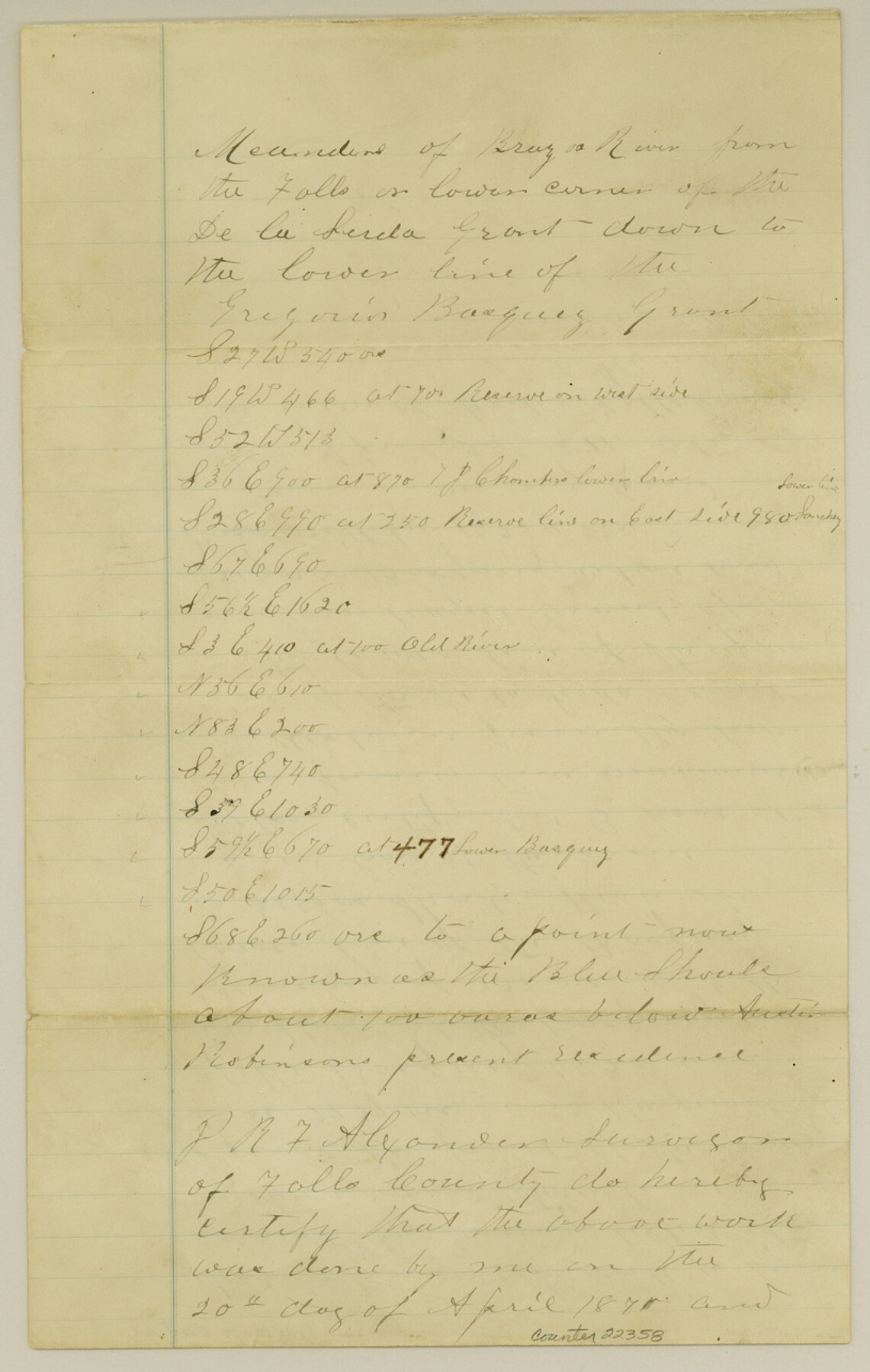
[Field notes and sketch of meanders of the Brazos River from the lower corner of A. de la Serda grant to the lower line of the G. Basquez grant]
-
Map/Doc
22358
-
Collection
General Map Collection
-
Object Dates
1871/4/24 (Creation Date)
1871/4/20 (Survey Date)
-
People and Organizations
R.F. Alexander (Surveyor/Engineer)
-
Counties
Falls
-
Subjects
Surveying Sketch File
-
Height x Width
12.9 x 8.2 inches
32.8 x 20.8 cm
-
Medium
paper, manuscript
-
Features
Brazos River
Blue Shoals
Old River
Part of: General Map Collection
Falls County Sketch File 17

Print $6.00
- Digital $50.00
Falls County Sketch File 17
1872
Size 8.4 x 13.1 inches
Map/Doc 22377
Flight Mission No. CRC-4R, Frame 68, Chambers County

Print $20.00
- Digital $50.00
Flight Mission No. CRC-4R, Frame 68, Chambers County
1956
Size 18.7 x 22.5 inches
Map/Doc 84872
Coast Chart No. 210 Aransas Pass and Corpus Christi Bay with the coast to latitude 27° 12' Texas

Print $20.00
- Digital $50.00
Coast Chart No. 210 Aransas Pass and Corpus Christi Bay with the coast to latitude 27° 12' Texas
1887
Size 27.6 x 18.2 inches
Map/Doc 72785
Flight Mission No. DJV-3P, Frame 14, Ellis County

Print $20.00
- Digital $50.00
Flight Mission No. DJV-3P, Frame 14, Ellis County
1956
Size 18.8 x 22.4 inches
Map/Doc 84976
Bexar County Sketch File 58a

Print $4.00
- Digital $50.00
Bexar County Sketch File 58a
1847
Size 10.2 x 8.2 inches
Map/Doc 14574
Flight Mission No. DQN-1K, Frame 135, Calhoun County

Print $20.00
- Digital $50.00
Flight Mission No. DQN-1K, Frame 135, Calhoun County
1953
Size 18.3 x 22.4 inches
Map/Doc 84198
Gaines County Working Sketch 13

Print $20.00
- Digital $50.00
Gaines County Working Sketch 13
1954
Size 36.8 x 39.4 inches
Map/Doc 69313
Grimes County Working Sketch 5

Print $40.00
- Digital $50.00
Grimes County Working Sketch 5
1949
Size 43.6 x 83.2 inches
Map/Doc 63296
Morris County Rolled Sketch 2A

Print $20.00
- Digital $50.00
Morris County Rolled Sketch 2A
Size 24.1 x 19.0 inches
Map/Doc 10279
Reeves County Sketch File 11

Print $20.00
- Digital $50.00
Reeves County Sketch File 11
1891
Size 20.1 x 17.9 inches
Map/Doc 12245
Aransas County Sketch File 36

Print $288.00
- Digital $50.00
Aransas County Sketch File 36
Size 8.5 x 10.9 inches
Map/Doc 13360
Flight Mission No. BRA-8M, Frame 83, Jefferson County

Print $20.00
- Digital $50.00
Flight Mission No. BRA-8M, Frame 83, Jefferson County
1953
Size 15.8 x 15.7 inches
Map/Doc 85603
You may also like
Maps of Gulf Intracoastal Waterway, Texas - Sabine River to the Rio Grande and connecting waterways including ship channels

Print $20.00
- Digital $50.00
Maps of Gulf Intracoastal Waterway, Texas - Sabine River to the Rio Grande and connecting waterways including ship channels
1966
Size 14.6 x 22.2 inches
Map/Doc 61955
Bosque County Working Sketch 20

Print $20.00
- Digital $50.00
Bosque County Working Sketch 20
1976
Size 37.4 x 32.8 inches
Map/Doc 67453
Fannin County Sketch File 19

Print $4.00
- Digital $50.00
Fannin County Sketch File 19
1878
Size 8.3 x 10.0 inches
Map/Doc 22473
Red River County Sketch File 24

Print $6.00
- Digital $50.00
Red River County Sketch File 24
1920
Size 11.4 x 8.8 inches
Map/Doc 35158
Hunt County Working Sketch 9

Print $20.00
- Digital $50.00
Hunt County Working Sketch 9
1959
Size 33.8 x 30.6 inches
Map/Doc 66356
Provincias internas del reyno de Nuevo España

Print $20.00
Provincias internas del reyno de Nuevo España
1846
Size 30.7 x 23.6 inches
Map/Doc 93578
Flight Mission No. BRA-7M, Frame 38, Jefferson County

Print $20.00
- Digital $50.00
Flight Mission No. BRA-7M, Frame 38, Jefferson County
1953
Size 18.6 x 22.4 inches
Map/Doc 85489

Houston County Working Sketch 36

Print $40.00
- Digital $50.00
Houston County Working Sketch 36
1987
Size 61.2 x 43.6 inches
Map/Doc 78231
Jefferson County Rolled Sketch 31

Print $425.00
- Digital $50.00
Jefferson County Rolled Sketch 31
1955
Size 10.1 x 15.3 inches
Map/Doc 46323
Primera parte del Mapa, que comprende la Frontera, de los Dominios del Rey, en la America Septentrional

Print $40.00
- Digital $50.00
Primera parte del Mapa, que comprende la Frontera, de los Dominios del Rey, en la America Septentrional
1769
Size 25.8 x 63.2 inches
Map/Doc 3062
Flight Mission No. DAH-17M, Frame 19, Orange County

Print $20.00
- Digital $50.00
Flight Mission No. DAH-17M, Frame 19, Orange County
1953
Size 18.6 x 22.6 inches
Map/Doc 86882