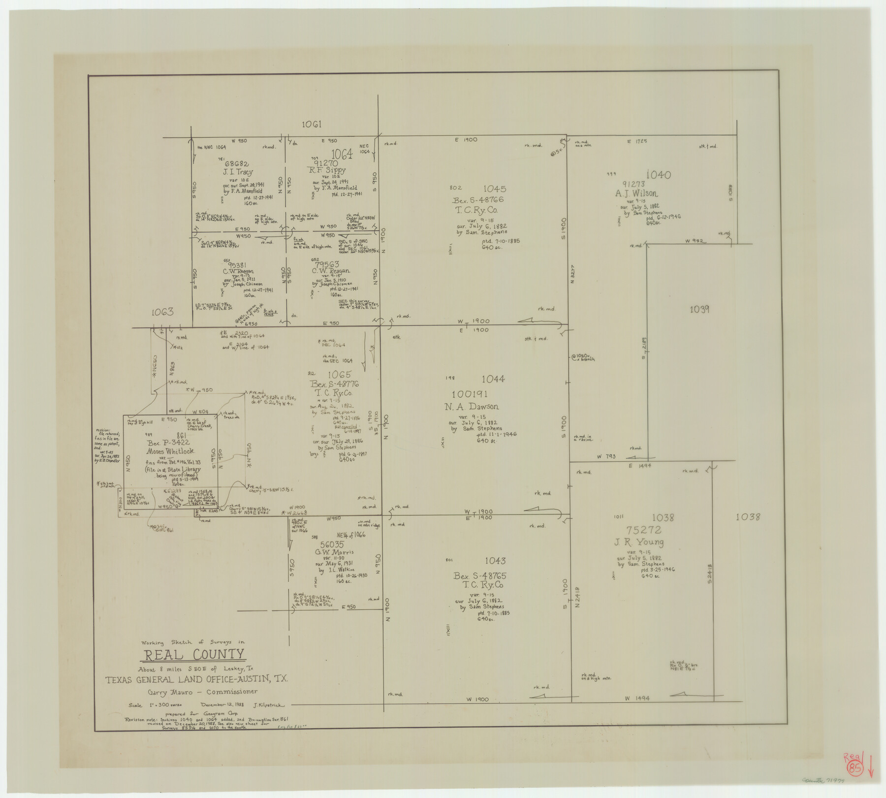
Real County Working Sketch 85
-
Map/Doc
71977
-
Collection
General Map Collection
-
Object Dates
12/12/1988 (Creation Date)
-
People and Organizations
Joan Kilpatrick (Draftsman)
-
Counties
Real
-
Subjects
Surveying Working Sketch
-
Height x Width
27.0 x 30.0 inches
68.6 x 76.2 cm
-
Scale
1" = 300 varas
Part of: General Map Collection
Irion County Working Sketch 2

Print $20.00
- Digital $50.00
Irion County Working Sketch 2
1921
Size 34.2 x 20.6 inches
Map/Doc 66411
Montague County Sketch File 21

Print $4.00
- Digital $50.00
Montague County Sketch File 21
1888
Size 12.4 x 8.3 inches
Map/Doc 31751
El Paso County Rolled Sketch 52

Print $20.00
- Digital $50.00
El Paso County Rolled Sketch 52
1929
Size 18.4 x 24.4 inches
Map/Doc 5845
Gulf Oil Corp. Fishgide - Freeport

Gulf Oil Corp. Fishgide - Freeport
1960
Size 12.3 x 22.4 inches
Map/Doc 75978
Kinney County Sketch File 12

Print $24.00
- Digital $50.00
Kinney County Sketch File 12
1885
Size 20.7 x 38.6 inches
Map/Doc 10618
Lubbock County Working Sketch 3

Print $20.00
- Digital $50.00
Lubbock County Working Sketch 3
1904
Size 13.9 x 20.5 inches
Map/Doc 70663
Shackelford County Rolled Sketch 4A

Print $40.00
- Digital $50.00
Shackelford County Rolled Sketch 4A
1984
Size 35.2 x 48.7 inches
Map/Doc 9917
Brooks County Working Sketch 19

Print $20.00
- Digital $50.00
Brooks County Working Sketch 19
1983
Size 31.7 x 18.4 inches
Map/Doc 67803
Bailey County Sketch File 11a

Print $4.00
- Digital $50.00
Bailey County Sketch File 11a
1912
Size 8.4 x 11.1 inches
Map/Doc 13967
Fannin County Boundary File 7

Print $42.00
- Digital $50.00
Fannin County Boundary File 7
Size 5.3 x 31.1 inches
Map/Doc 53313
Kerr County Sketch File 1c

Print $4.00
- Digital $50.00
Kerr County Sketch File 1c
1951
Size 12.3 x 8.3 inches
Map/Doc 28851
Flight Mission No. DQN-3K, Frame 73, Calhoun County

Print $20.00
- Digital $50.00
Flight Mission No. DQN-3K, Frame 73, Calhoun County
1953
Size 18.6 x 22.4 inches
Map/Doc 84364
You may also like
Texas Gulf Coast, from the Sabine River to the Rio Grande as Subdivided for Mineral Development; Matagorda, Calhoun and Aransas Counties

Print $40.00
- Digital $50.00
Texas Gulf Coast, from the Sabine River to the Rio Grande as Subdivided for Mineral Development; Matagorda, Calhoun and Aransas Counties
1976
Size 43.0 x 90.9 inches
Map/Doc 1939
Williamson County Working Sketch 11

Print $20.00
- Digital $50.00
Williamson County Working Sketch 11
1961
Size 37.3 x 36.2 inches
Map/Doc 72571
[H. & T. C. Blocks 25 and 26]
![92025, [H. & T. C. Blocks 25 and 26], Twichell Survey Records](https://historictexasmaps.com/wmedia_w700/maps/92025-1.tif.jpg)
Print $20.00
- Digital $50.00
[H. & T. C. Blocks 25 and 26]
1873
Size 42.2 x 33.9 inches
Map/Doc 92025
Town of Wellman Situated on Parts of the Northeast 1/4 and Northwest 1/4 Section 17, Block DD

Print $20.00
- Digital $50.00
Town of Wellman Situated on Parts of the Northeast 1/4 and Northwest 1/4 Section 17, Block DD
1924
Size 14.3 x 12.3 inches
Map/Doc 92886
DeWitt County Working Sketch 11

Print $20.00
- Digital $50.00
DeWitt County Working Sketch 11
1980
Size 15.9 x 12.8 inches
Map/Doc 68601
Fayette County Rolled Sketch 1

Print $20.00
- Digital $50.00
Fayette County Rolled Sketch 1
1981
Size 20.9 x 25.8 inches
Map/Doc 5876
Travis County Appraisal District Plat Map 2_2512

Print $20.00
- Digital $50.00
Travis County Appraisal District Plat Map 2_2512
1938
Size 21.5 x 26.5 inches
Map/Doc 94216
A New Map of Texas, Oregon and California with the Regions adjoining

Print $20.00
- Digital $50.00
A New Map of Texas, Oregon and California with the Regions adjoining
1846
Size 20.4 x 19.3 inches
Map/Doc 89067
Harris County Working Sketch 58

Print $20.00
- Digital $50.00
Harris County Working Sketch 58
1952
Size 24.1 x 26.5 inches
Map/Doc 65950
Flight Mission No. DQN-2K, Frame 79, Calhoun County

Print $20.00
- Digital $50.00
Flight Mission No. DQN-2K, Frame 79, Calhoun County
1953
Size 16.0 x 16.0 inches
Map/Doc 84271
Harris County Sketch File A1

Print $20.00
- Digital $50.00
Harris County Sketch File A1
Size 12.3 x 15.2 inches
Map/Doc 25308
Lynn County Sketch File 19

Print $36.00
- Digital $50.00
Lynn County Sketch File 19
Size 11.2 x 8.7 inches
Map/Doc 30519