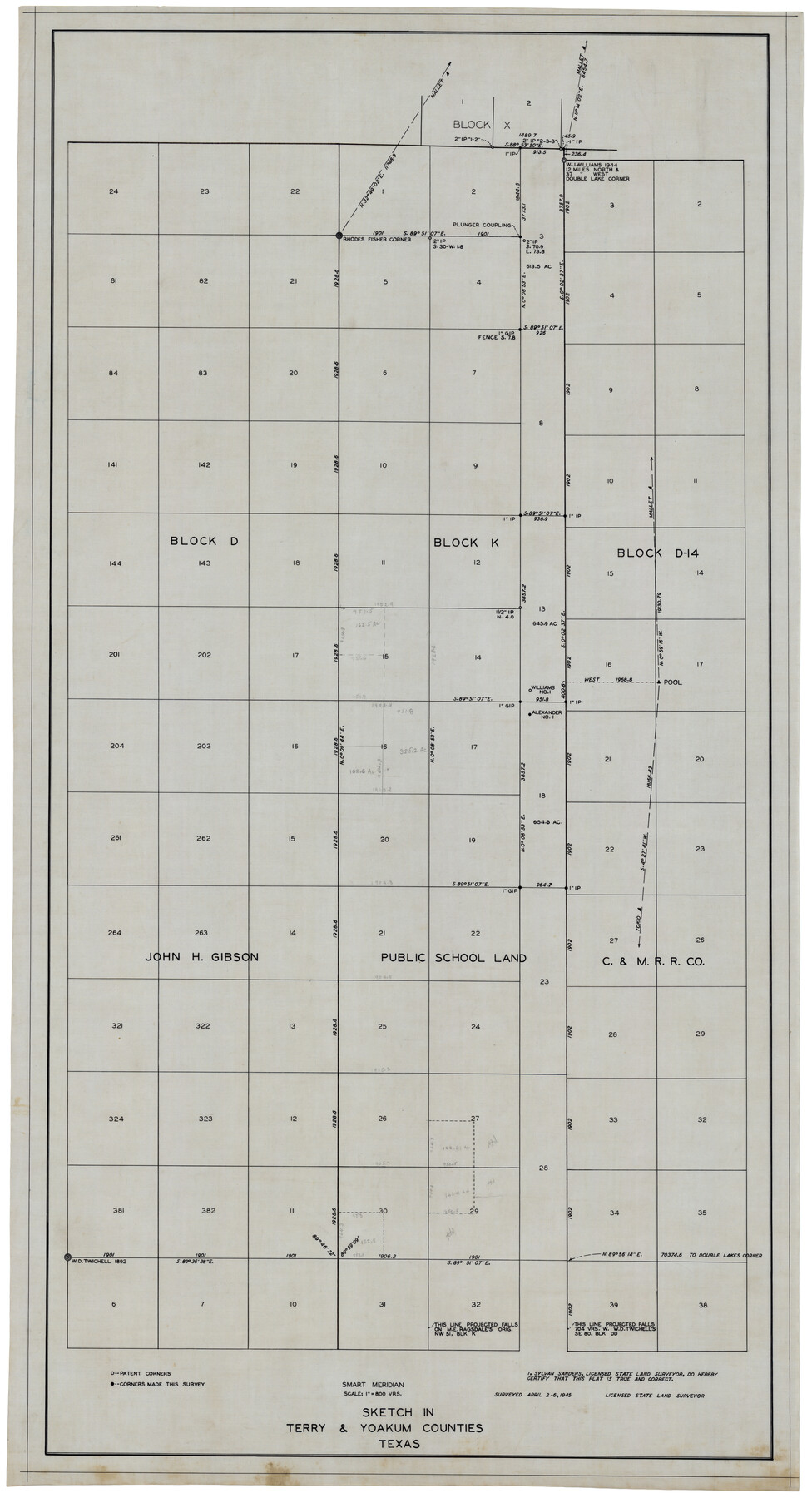
Sketch in Terry & Yoakum Counties
-
Map/Doc
92854
-
Collection
Twichell Survey Records
-
Object Dates
4/26/1945 (Creation Date)
-
People and Organizations
Sylvan Sanders (Surveyor/Engineer)
-
Counties
Yoakum
-
Height x Width
21.8 x 40.0 inches
55.4 x 101.6 cm
Part of: Twichell Survey Records

Working Sketch in Garza County [J. Hays Block 1]
![90920, Working Sketch in Garza County [J. Hays Block 1], Twichell Survey Records](https://historictexasmaps.com/wmedia_w700/maps/90920-1.tif.jpg)
Print $2.00
- Digital $50.00
Working Sketch in Garza County [J. Hays Block 1]
1903
Size 9.1 x 12.4 inches
Map/Doc 90920
Block 11, Capitol Syndicate Subdivision of Capitol Land Reservation Leagues

Print $20.00
- Digital $50.00
Block 11, Capitol Syndicate Subdivision of Capitol Land Reservation Leagues
Size 25.0 x 26.2 inches
Map/Doc 90737
City Leased Property in Bailey County, Texas

Print $40.00
- Digital $50.00
City Leased Property in Bailey County, Texas
1952
Size 65.9 x 42.7 inches
Map/Doc 89868
[Blocks 3, 5 & Q]
![91275, [Blocks 3, 5 & Q], Twichell Survey Records](https://historictexasmaps.com/wmedia_w700/maps/91275-1.tif.jpg)
Print $20.00
- Digital $50.00
[Blocks 3, 5 & Q]
Size 19.4 x 9.2 inches
Map/Doc 91275
Map of the Northeast Part of the Pitchfork Ranch

Print $20.00
- Digital $50.00
Map of the Northeast Part of the Pitchfork Ranch
1916
Size 23.4 x 23.4 inches
Map/Doc 90980
Survey of Improvements on Meeks Gin Site Town of Ropes Hockley County, Texas

Print $20.00
- Digital $50.00
Survey of Improvements on Meeks Gin Site Town of Ropes Hockley County, Texas
1957
Size 13.0 x 17.6 inches
Map/Doc 92214
[Worksheets related to the Wilson Strickland survey and vicinity]
![91269, [Worksheets related to the Wilson Strickland survey and vicinity], Twichell Survey Records](https://historictexasmaps.com/wmedia_w700/maps/91269.tif.jpg)
Print $20.00
- Digital $50.00
[Worksheets related to the Wilson Strickland survey and vicinity]
Size 25.7 x 21.7 inches
Map/Doc 91269
[Blocks B-19, B-29, 34 and 5]
![91846, [Blocks B-19, B-29, 34 and 5], Twichell Survey Records](https://historictexasmaps.com/wmedia_w700/maps/91846-1.tif.jpg)
Print $20.00
- Digital $50.00
[Blocks B-19, B-29, 34 and 5]
1902
Size 12.2 x 16.4 inches
Map/Doc 91846
[University Lands Blocks 16-20]
![91628, [University Lands Blocks 16-20], Twichell Survey Records](https://historictexasmaps.com/wmedia_w700/maps/91628-1.tif.jpg)
Print $3.00
- Digital $50.00
[University Lands Blocks 16-20]
Size 14.5 x 11.2 inches
Map/Doc 91628
[H. & T. C. Blocks 47 1/2 and 48, Capitol Lands]
![90639, [H. & T. C. Blocks 47 1/2 and 48, Capitol Lands], Twichell Survey Records](https://historictexasmaps.com/wmedia_w700/maps/90639-1.tif.jpg)
Print $20.00
- Digital $50.00
[H. & T. C. Blocks 47 1/2 and 48, Capitol Lands]
Size 19.9 x 24.8 inches
Map/Doc 90639
Working Sketch in Stephens County

Print $20.00
- Digital $50.00
Working Sketch in Stephens County
1919
Size 11.1 x 20.6 inches
Map/Doc 91903
You may also like
Galveston Bay Entrance - Galveston and Texas City Harbors

Print $40.00
- Digital $50.00
Galveston Bay Entrance - Galveston and Texas City Harbors
1975
Size 37.4 x 53.5 inches
Map/Doc 69864
[Sketch of Part of B. S. & F. Block 9]
![93090, [Sketch of Part of B. S. & F. Block 9], Twichell Survey Records](https://historictexasmaps.com/wmedia_w700/maps/93090-1.tif.jpg)
Print $2.00
- Digital $50.00
[Sketch of Part of B. S. & F. Block 9]
Size 7.6 x 7.4 inches
Map/Doc 93090
Bell County Boundary File 3

Print $24.00
- Digital $50.00
Bell County Boundary File 3
Size 11.1 x 8.6 inches
Map/Doc 50490
Hutchinson County Sketch File 20m

Print $20.00
- Digital $50.00
Hutchinson County Sketch File 20m
Size 36.2 x 43.6 inches
Map/Doc 10501
Boundary Between the United States & Mexico Agreed Upon by the Joint Commission under the Treaty of Guadalupe Hidalgo

Print $4.00
- Digital $50.00
Boundary Between the United States & Mexico Agreed Upon by the Joint Commission under the Treaty of Guadalupe Hidalgo
1853
Size 24.4 x 18.8 inches
Map/Doc 65395
Terrell County Working Sketch 19

Print $20.00
- Digital $50.00
Terrell County Working Sketch 19
1932
Size 18.8 x 25.7 inches
Map/Doc 62169
Jones County Sketch File 10

Print $20.00
- Digital $50.00
Jones County Sketch File 10
1875
Size 14.3 x 22.2 inches
Map/Doc 11900
Stonewall County Working Sketch 33

Print $40.00
- Digital $50.00
Stonewall County Working Sketch 33
1984
Size 70.4 x 42.8 inches
Map/Doc 62340
Flight Mission No. DQO-8K, Frame 22, Galveston County

Print $20.00
- Digital $50.00
Flight Mission No. DQO-8K, Frame 22, Galveston County
1952
Size 18.7 x 22.3 inches
Map/Doc 85145
Wood County Rolled Sketch 9

Print $20.00
- Digital $50.00
Wood County Rolled Sketch 9
Size 30.6 x 18.1 inches
Map/Doc 8287
Dallam County Working Sketch 4

Print $20.00
- Digital $50.00
Dallam County Working Sketch 4
1974
Size 31.2 x 32.0 inches
Map/Doc 68589
Intracoastal Waterway in Texas - Corpus Christi to Point Isabel including Arroyo Colorado to Mo. Pac. R.R. Bridge Near Harlingen

Print $20.00
- Digital $50.00
Intracoastal Waterway in Texas - Corpus Christi to Point Isabel including Arroyo Colorado to Mo. Pac. R.R. Bridge Near Harlingen
1933
Size 28.4 x 41.2 inches
Map/Doc 61870