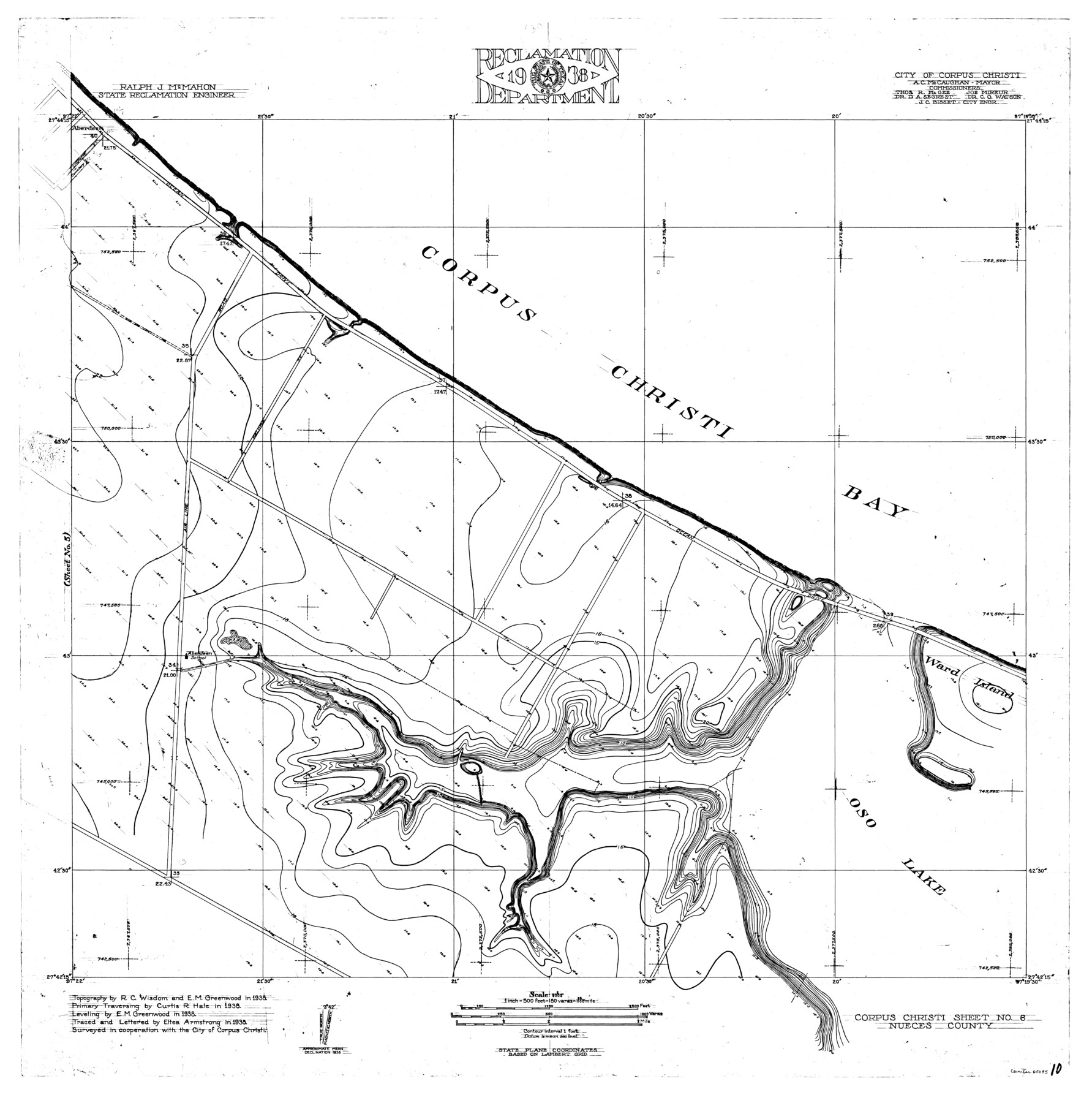
Nueces River, Corpus Christi Sheet No. 6
-
Map/Doc
65095
-
Collection
General Map Collection
-
Object Dates
1938 (Creation Date)
-
People and Organizations
Texas State Reclamation Department (Publisher)
Eltea Armstrong (Draftsman)
Eltea Armstrong (Compiler)
Curtis R. Hale (Surveyor/Engineer)
R.C. Wisdom (Surveyor/Engineer)
E.M. Greenwood (Surveyor/Engineer)
-
Counties
Nueces
-
Subjects
City River Surveys Topographic
-
Height x Width
31.3 x 31.0 inches
79.5 x 78.7 cm
-
Comments
Corpus Christi Sheet No. 6 located east of the Corpus Christi Sheet No. 5 .
Part of: General Map Collection
Dallas County Working Sketch 14

Print $20.00
- Digital $50.00
Dallas County Working Sketch 14
1987
Size 31.2 x 21.7 inches
Map/Doc 68580
Map of San Patricio County

Print $20.00
- Digital $50.00
Map of San Patricio County
1883
Size 17.2 x 26.8 inches
Map/Doc 4017
Map of Nacogdoches County

Print $20.00
- Digital $50.00
Map of Nacogdoches County
1881
Size 24.0 x 21.3 inches
Map/Doc 4602
Wheeler County Rolled Sketch 1

Print $20.00
- Digital $50.00
Wheeler County Rolled Sketch 1
1941
Size 43.9 x 23.7 inches
Map/Doc 10136
Southern Part of Laguna Madre

Print $20.00
- Digital $50.00
Southern Part of Laguna Madre
1975
Size 45.1 x 35.0 inches
Map/Doc 73545

Wise County Sketch File 7

Print $4.00
- Digital $50.00
Wise County Sketch File 7
1857
Size 8.1 x 14.0 inches
Map/Doc 40535
Frio County Rolled Sketch 13

Print $20.00
- Digital $50.00
Frio County Rolled Sketch 13
1949
Size 36.8 x 26.7 inches
Map/Doc 5920

Dawson County Rolled Sketch 3

Print $20.00
- Digital $50.00
Dawson County Rolled Sketch 3
1903
Size 20.9 x 36.8 inches
Map/Doc 8770
Cooke County Working Sketch 7

Print $20.00
- Digital $50.00
Cooke County Working Sketch 7
1939
Size 25.1 x 33.7 inches
Map/Doc 68244
Coke County Rolled Sketch 14B

Print $20.00
- Digital $50.00
Coke County Rolled Sketch 14B
Size 16.3 x 19.3 inches
Map/Doc 5516
You may also like
Map of San Antonio Bay and Vicinity in Aransas and Calhoun Counties showing subdivision for mineral development

Print $40.00
- Digital $50.00
Map of San Antonio Bay and Vicinity in Aransas and Calhoun Counties showing subdivision for mineral development
1939
Size 40.4 x 62.8 inches
Map/Doc 2925
Red River County Sketch File 10

Print $15.00
- Digital $50.00
Red River County Sketch File 10
1863
Size 9.1 x 7.4 inches
Map/Doc 35121
La Salle County Working Sketch 11

Print $20.00
- Digital $50.00
La Salle County Working Sketch 11
1929
Size 29.3 x 20.7 inches
Map/Doc 70312
Terrell County Working Sketch 36

Print $20.00
- Digital $50.00
Terrell County Working Sketch 36
1948
Size 26.8 x 39.9 inches
Map/Doc 62129
Mills County Working Sketch 24

Print $20.00
- Digital $50.00
Mills County Working Sketch 24
1988
Size 40.3 x 36.5 inches
Map/Doc 71054
Comanche County Sketch File 11

Print $4.00
- Digital $50.00
Comanche County Sketch File 11
Size 8.6 x 15.3 inches
Map/Doc 19072
Angelina County Boundary File 2

Print $20.00
- Digital $50.00
Angelina County Boundary File 2
Size 10.2 x 28.2 inches
Map/Doc 49773
![90328, [Block B9], Twichell Survey Records](https://historictexasmaps.com/wmedia_w700/maps/90328-1.tif.jpg)
Walker County Rolled Sketch 1

Print $20.00
- Digital $50.00
Walker County Rolled Sketch 1
1982
Size 36.3 x 23.6 inches
Map/Doc 8154
Anderson County Rolled Sketch 10

Print $20.00
- Digital $50.00
Anderson County Rolled Sketch 10
1956
Size 33.4 x 34.6 inches
Map/Doc 8365
Andrews County Boundary File 4

Print $40.00
- Digital $50.00
Andrews County Boundary File 4
Size 35.4 x 7.1 inches
Map/Doc 49721
Harris County Rolled Sketch T1

Print $20.00
- Digital $50.00
Harris County Rolled Sketch T1
1916
Size 29.8 x 24.3 inches
Map/Doc 6144