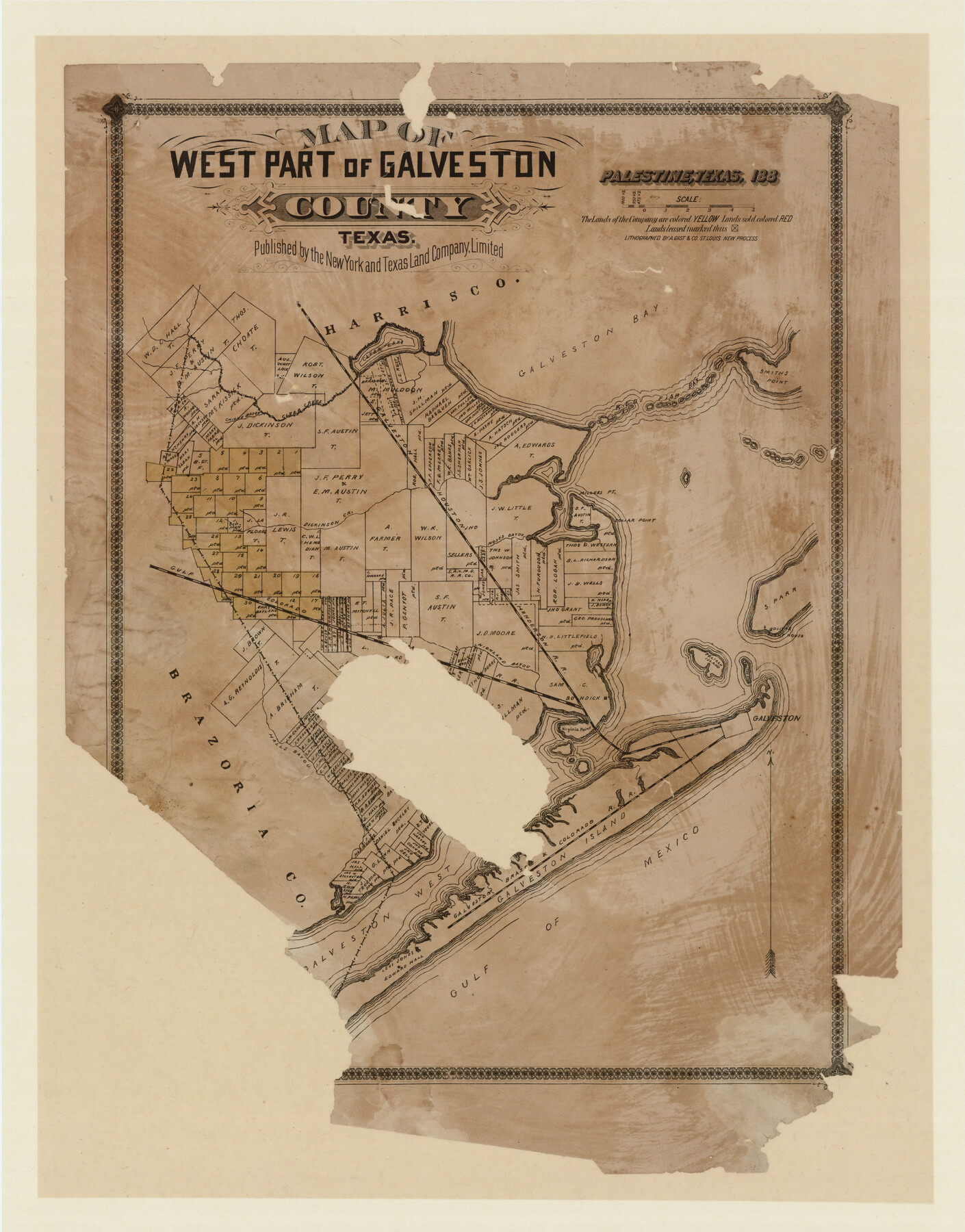
Map of West Part of Galveston County, Texas
-
Map/Doc
716
-
Collection
Maddox Collection
-
Object Dates
1880 (Creation Date)
-
People and Organizations
New York and Texas Land Company (Publisher)
August Gast & Co. (Lithographer)
-
Counties
Galveston
-
Subjects
County
-
Height x Width
28.6 x 21.9 inches
72.6 x 55.6 cm
-
Medium
paper, etching/engraving/lithograph
-
Scale
1" = 3800 varas
-
Comments
Conservation funded by Friends of the Texas General Land Office in 2011.
Scale approximated from bar scale. -
Features
Henderson Railroad
Galveston West
GB&C
Galveston Island
Gulf of Mexico
Pelican Spit
Galveston
Virginia Point
Bundick
Halls Bayou
GC&SF
Highland Bayou
Chigoe Bayou
Pelican Island
Bolivar Lighthouse
Dickinson Creek
GH&H
Moses Bayou
Millers Point
Dollar Point
Smiths Point
Red Fish Bay
Clear Lake
Clear Creek
Part of: Maddox Collection
McClennan [sic] County, Texas
![577, McClennan [sic] County, Texas, Maddox Collection](https://historictexasmaps.com/wmedia_w700/maps/577.tif.jpg)
Print $20.00
- Digital $50.00
McClennan [sic] County, Texas
1880
Size 23.5 x 26.7 inches
Map/Doc 577
Sketch in Atascosa County

Print $3.00
- Digital $50.00
Sketch in Atascosa County
1890
Size 12.6 x 11.4 inches
Map/Doc 578
Sketch of Dickens Co.

Print $20.00
- Digital $50.00
Sketch of Dickens Co.
1884
Size 17.6 x 14.5 inches
Map/Doc 75766
Map of Encinal County, Texas

Print $20.00
- Digital $50.00
Map of Encinal County, Texas
1879
Size 22.7 x 28.4 inches
Map/Doc 715
Map of Upshur County, Texas

Print $20.00
- Digital $50.00
Map of Upshur County, Texas
1879
Size 21.5 x 17.5 inches
Map/Doc 763
Map of Frio County, Texas

Print $20.00
- Digital $50.00
Map of Frio County, Texas
1879
Size 22.8 x 21.9 inches
Map/Doc 545
Map Showing Position of Surveys Represented Hereon

Print $40.00
- Digital $50.00
Map Showing Position of Surveys Represented Hereon
Size 38.9 x 57.2 inches
Map/Doc 75809
Map of Fisher & Miller's Colony made from the records in the office of the District Surveyor of Bexar comprising also all the recent surveys

Print $20.00
- Digital $50.00
Map of Fisher & Miller's Colony made from the records in the office of the District Surveyor of Bexar comprising also all the recent surveys
1855
Size 22.6 x 36.2 inches
Map/Doc 633
San Antonio del Encinal as Corrected

Print $20.00
- Digital $50.00
San Antonio del Encinal as Corrected
1916
Size 31.2 x 31.5 inches
Map/Doc 10757
[Sketch of H & T C RR Co. Blocks north of the Canadian River, Hemphill County, Texas]
![10758, [Sketch of H & T C RR Co. Blocks north of the Canadian River, Hemphill County, Texas], Maddox Collection](https://historictexasmaps.com/wmedia_w700/maps/10758-GC.tif.jpg)
Print $3.00
- Digital $50.00
[Sketch of H & T C RR Co. Blocks north of the Canadian River, Hemphill County, Texas]
Size 10.4 x 16.1 inches
Map/Doc 10758
Survey 1, Block 1, D.B. Gardner in Dickens County

Print $20.00
- Digital $50.00
Survey 1, Block 1, D.B. Gardner in Dickens County
1914
Size 14.9 x 30.4 inches
Map/Doc 10767
Austin, Texas Congress Ave. Drainage

Print $20.00
- Digital $50.00
Austin, Texas Congress Ave. Drainage
1903
Size 15.3 x 15.4 inches
Map/Doc 75798
You may also like
Map of McLennan Co[unty]
![88974, Map of McLennan Co[unty], Library of Congress](https://historictexasmaps.com/wmedia_w700/maps/88974.tif.jpg)
Print $40.00
Map of McLennan Co[unty]
1896
Size 47.9 x 53.6 inches
Map/Doc 88974
Map of Atascosa Co.

Print $40.00
- Digital $50.00
Map of Atascosa Co.
1894
Size 48.3 x 46.6 inches
Map/Doc 4877
The Republic County of Bastrop. December 29, 1845

Print $20.00
The Republic County of Bastrop. December 29, 1845
2020
Size 14.8 x 21.7 inches
Map/Doc 96092

Nueces County Rolled Sketch 119

Print $90.00
Nueces County Rolled Sketch 119
1994
Size 26.1 x 36.5 inches
Map/Doc 7151
Map of the State of Texas from the most recent authorities

Print $20.00
- Digital $50.00
Map of the State of Texas from the most recent authorities
1850
Size 13.8 x 17.3 inches
Map/Doc 89251
Brooks County Working Sketch 16

Print $20.00
- Digital $50.00
Brooks County Working Sketch 16
1972
Size 35.0 x 29.7 inches
Map/Doc 67800
Brazoria County Working Sketch 39

Print $40.00
- Digital $50.00
Brazoria County Working Sketch 39
1981
Size 74.6 x 44.1 inches
Map/Doc 67524
El Paso County Sketch File 11

Print $6.00
- Digital $50.00
El Paso County Sketch File 11
Size 14.2 x 11.0 inches
Map/Doc 22000
Brazos Santiago, Texas

Print $20.00
- Digital $50.00
Brazos Santiago, Texas
1867
Size 25.1 x 18.3 inches
Map/Doc 72988
Flight Mission No. DAG-21K, Frame 41, Matagorda County

Print $20.00
- Digital $50.00
Flight Mission No. DAG-21K, Frame 41, Matagorda County
1952
Size 18.6 x 19.3 inches
Map/Doc 86408
Bowie County Working Sketch 21

Print $20.00
- Digital $50.00
Bowie County Working Sketch 21
1968
Size 35.9 x 36.3 inches
Map/Doc 67425