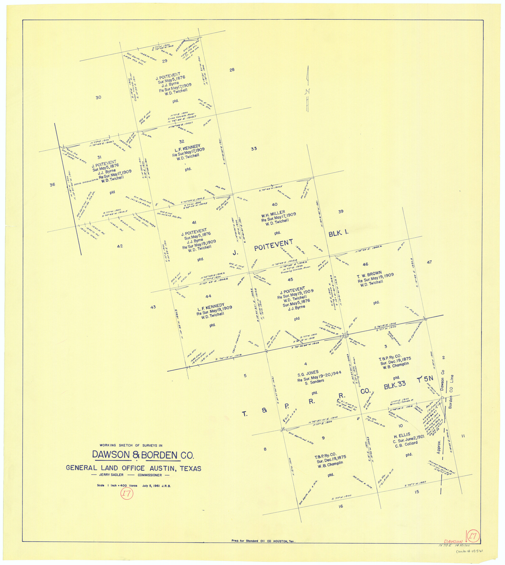
Dawson County Working Sketch 17
-
Map/Doc
68561
-
Collection
General Map Collection
-
Object Dates
7/5/1961 (Creation Date)
-
Counties
Dawson Borden
-
Subjects
Surveying Working Sketch
-
Height x Width
33.3 x 29.9 inches
84.6 x 76.0 cm
-
Scale
1" = 400 varas
Part of: General Map Collection
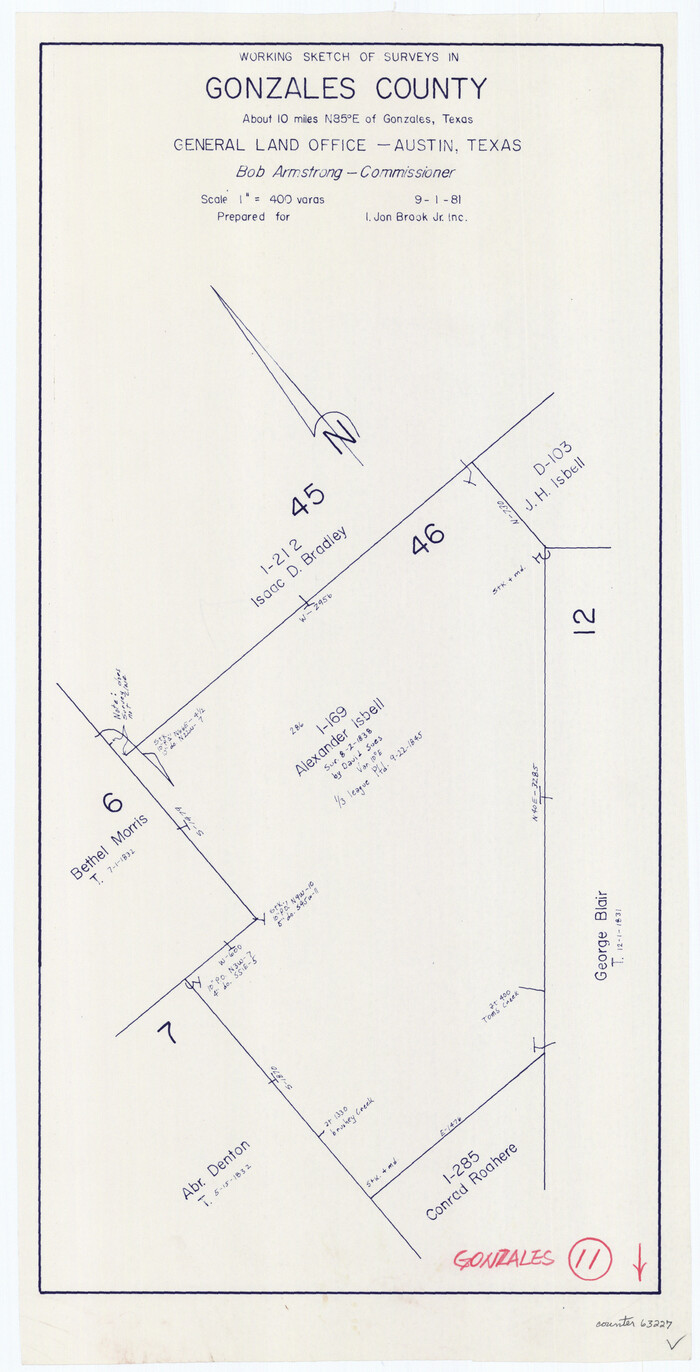
Gonzales County Working Sketch 11
Print $20.00
- Digital $50.00
Gonzales County Working Sketch 11
1981
Size 22.2 x 11.3 inches
Map/Doc 63227
Dawson County Rolled Sketch 12

Print $20.00
- Digital $50.00
Dawson County Rolled Sketch 12
1965
Size 15.6 x 33.2 inches
Map/Doc 5695
Calhoun County Rolled Sketch 30

Print $20.00
- Digital $50.00
Calhoun County Rolled Sketch 30
1974
Size 18.8 x 27.6 inches
Map/Doc 5494
Montague County Working Sketch 38

Print $20.00
- Digital $50.00
Montague County Working Sketch 38
1990
Size 14.9 x 15.6 inches
Map/Doc 71104
Howard County Rolled Sketch 2

Print $20.00
- Digital $50.00
Howard County Rolled Sketch 2
1905
Size 27.6 x 23.0 inches
Map/Doc 6232
Brazos River, Harlem-Imperial Farms Project

Print $4.00
- Digital $50.00
Brazos River, Harlem-Imperial Farms Project
1931
Size 29.4 x 26.6 inches
Map/Doc 65285
East Half - Brown County

Print $40.00
- Digital $50.00
East Half - Brown County
1982
Size 141.3 x 36.8 inches
Map/Doc 97385
Topographical Map of the Rio Grande, Sheet No. 16

Print $20.00
- Digital $50.00
Topographical Map of the Rio Grande, Sheet No. 16
1912
Map/Doc 89540
Williamson County Sketch File 27

Print $12.00
- Digital $50.00
Williamson County Sketch File 27
1940
Size 14.3 x 8.7 inches
Map/Doc 40371
Flight Mission No. CLL-1N, Frame 77, Willacy County

Print $20.00
- Digital $50.00
Flight Mission No. CLL-1N, Frame 77, Willacy County
1954
Size 18.4 x 22.1 inches
Map/Doc 87023
Val Verde County Sketch File 11

Print $8.00
- Digital $50.00
Val Verde County Sketch File 11
1972
Size 11.3 x 8.9 inches
Map/Doc 39110
Bee County Sketch File 16

Print $4.00
- Digital $50.00
Bee County Sketch File 16
1878
Size 8.6 x 7.7 inches
Map/Doc 14299
You may also like
Tom Green County Sketch File 50

Print $20.00
- Digital $50.00
Tom Green County Sketch File 50
1884
Size 25.4 x 34.5 inches
Map/Doc 12442
Flight Mission No. CUG-3P, Frame 79, Kleberg County

Print $20.00
- Digital $50.00
Flight Mission No. CUG-3P, Frame 79, Kleberg County
1956
Size 18.4 x 22.2 inches
Map/Doc 86254
Crockett County Rolled Sketch CP

Print $20.00
- Digital $50.00
Crockett County Rolled Sketch CP
1928
Size 39.9 x 30.8 inches
Map/Doc 8695
Red River County Working Sketch 48

Print $20.00
- Digital $50.00
Red River County Working Sketch 48
1970
Size 28.6 x 30.2 inches
Map/Doc 72031
Flight Mission No. BRA-8M, Frame 143, Jefferson County

Print $20.00
- Digital $50.00
Flight Mission No. BRA-8M, Frame 143, Jefferson County
1953
Size 18.9 x 22.5 inches
Map/Doc 85635
The Chief Justice County of Matagorda. March 30, 1837

Print $20.00
The Chief Justice County of Matagorda. March 30, 1837
2020
Size 19.7 x 21.7 inches
Map/Doc 96057

Conoco Official Road Map New Mexico

Print $20.00
- Digital $50.00
Conoco Official Road Map New Mexico
1934
Size 18.5 x 24.4 inches
Map/Doc 92436
[Stone, Kyle and Kyle Block M6]
![90414, [Stone, Kyle and Kyle Block M6], Twichell Survey Records](https://historictexasmaps.com/wmedia_w700/maps/90414-1.tif.jpg)
Print $20.00
- Digital $50.00
[Stone, Kyle and Kyle Block M6]
1908
Size 18.6 x 25.5 inches
Map/Doc 90414
Smith County Rolled Sketch 3

Print $40.00
- Digital $50.00
Smith County Rolled Sketch 3
Size 55.2 x 42.8 inches
Map/Doc 9934
Topographical Map of the Rio Grande from Roma to the Gulf of Mexico, Index Map, Sheet No. 2

Print $20.00
- Digital $50.00
Topographical Map of the Rio Grande from Roma to the Gulf of Mexico, Index Map, Sheet No. 2
1912
Map/Doc 89524
Flight Mission No. DCL-4C, Frame 66, Kenedy County

Print $20.00
- Digital $50.00
Flight Mission No. DCL-4C, Frame 66, Kenedy County
1943
Size 18.6 x 22.3 inches
Map/Doc 85811