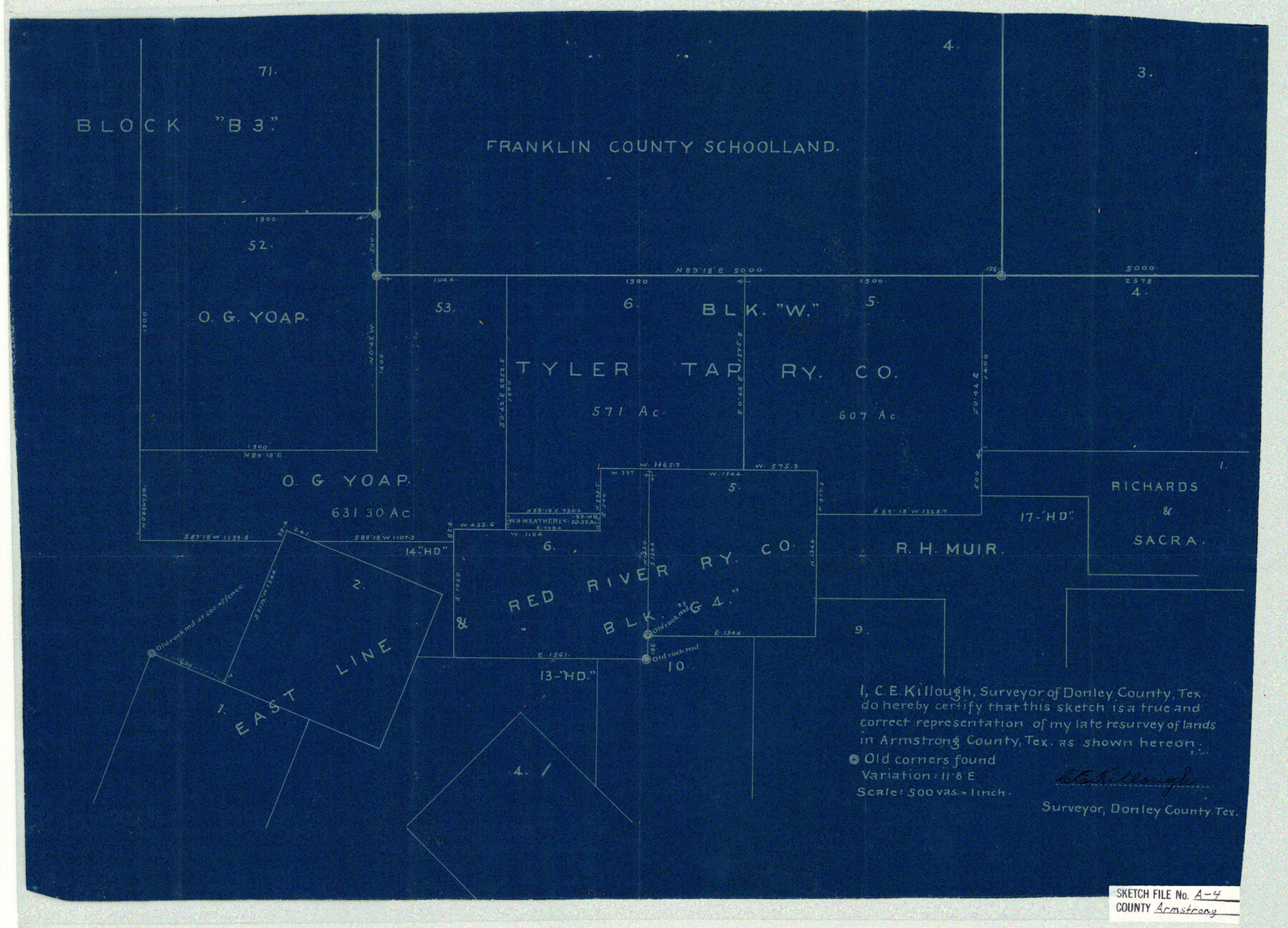
Armstrong County Sketch File A-4
[Sketch showing parts of Blocks G4 and C5]
-
Map/Doc
10845
-
Collection
General Map Collection
-
People and Organizations
C.E. Killough (Surveyor/Engineer)
-
Counties
Armstrong Donley
-
Subjects
Surveying Sketch File
-
Height x Width
14.8 x 20.5 inches
37.6 x 52.1 cm
-
Medium
blueprint/diazo
-
Scale
1" = 500 varas
Part of: General Map Collection
Dallas County Boundary File 6c

Print $4.00
- Digital $50.00
Dallas County Boundary File 6c
Size 14.0 x 8.6 inches
Map/Doc 52227
Robertson County Sketch File 12

Print $18.00
Robertson County Sketch File 12
1987
Size 11.4 x 8.8 inches
Map/Doc 35404
Flight Mission No. BRA-7M, Frame 20, Jefferson County

Print $20.00
- Digital $50.00
Flight Mission No. BRA-7M, Frame 20, Jefferson County
1953
Size 18.6 x 22.2 inches
Map/Doc 85471
Presidio County Sketch File 68

Print $4.00
- Digital $50.00
Presidio County Sketch File 68
1941
Size 11.2 x 8.8 inches
Map/Doc 34662
Tyler County Working Sketch 19

Print $20.00
- Digital $50.00
Tyler County Working Sketch 19
1967
Size 47.8 x 42.9 inches
Map/Doc 69489
Plat of a survey on Padre Island in Willacy County surveyed for South Padre Development Corporation by Settles and Claunch

Print $40.00
- Digital $50.00
Plat of a survey on Padre Island in Willacy County surveyed for South Padre Development Corporation by Settles and Claunch
1966
Size 78.6 x 41.6 inches
Map/Doc 61427

Gaines County Rolled Sketch 34

Print $20.00
- Digital $50.00
Gaines County Rolled Sketch 34
2002
Size 20.1 x 22.3 inches
Map/Doc 77533
A Geographically Correct Map of the State of Texas

Print $20.00
- Digital $50.00
A Geographically Correct Map of the State of Texas
1876
Size 20.4 x 21.9 inches
Map/Doc 95362
Refugio County Working Sketch 2

Print $20.00
- Digital $50.00
Refugio County Working Sketch 2
1927
Size 17.6 x 19.4 inches
Map/Doc 63511
San Patricio County Working Sketch 3

Print $20.00
- Digital $50.00
San Patricio County Working Sketch 3
1917
Size 22.2 x 42.7 inches
Map/Doc 63765
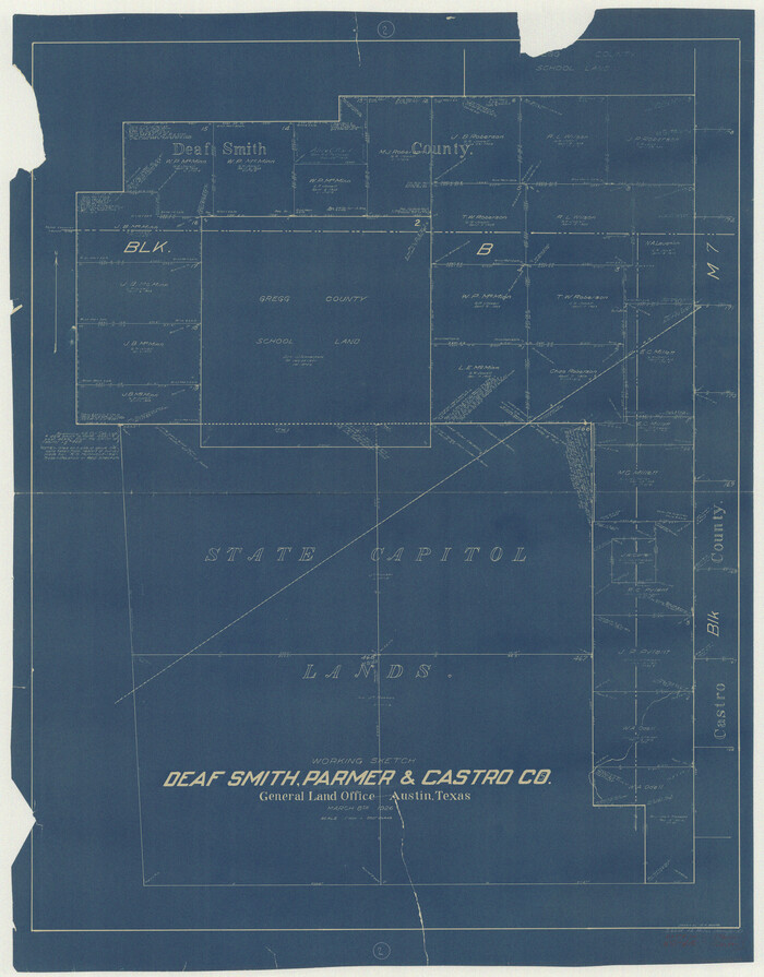
Deaf Smith County Working Sketch 2
Print $20.00
- Digital $50.00
Deaf Smith County Working Sketch 2
1926
Size 42.3 x 33.1 inches
Map/Doc 68642
You may also like
Hudspeth County Sketch File 23

Print $20.00
- Digital $50.00
Hudspeth County Sketch File 23
1935
Size 15.1 x 26.9 inches
Map/Doc 11801
Reagan County Working Sketch 37

Print $20.00
- Digital $50.00
Reagan County Working Sketch 37
1966
Size 34.3 x 45.1 inches
Map/Doc 71879
Wise County Working Sketch 15

Print $20.00
- Digital $50.00
Wise County Working Sketch 15
1979
Size 23.3 x 24.6 inches
Map/Doc 72629
Starr County Sketch File 42

Print $20.00
- Digital $50.00
Starr County Sketch File 42
1941
Size 19.0 x 21.6 inches
Map/Doc 12341
Upton County Boundary File 1

Print $5.00
- Digital $50.00
Upton County Boundary File 1
Size 13.4 x 9.0 inches
Map/Doc 59506
Wood County Rolled Sketch 3

Print $20.00
- Digital $50.00
Wood County Rolled Sketch 3
1941
Size 35.2 x 30.8 inches
Map/Doc 8282
Live Oak County Rolled Sketch 1

Print $20.00
- Digital $50.00
Live Oak County Rolled Sketch 1
1943
Size 25.6 x 42.4 inches
Map/Doc 6631
Shackelford County Sketch File 7

Print $20.00
- Digital $50.00
Shackelford County Sketch File 7
1912
Size 27.2 x 13.5 inches
Map/Doc 12314
General Highway Map, Crosby County, Texas

Print $20.00
General Highway Map, Crosby County, Texas
1961
Size 18.1 x 24.5 inches
Map/Doc 79426
Terrell County Working Sketch 70

Print $20.00
- Digital $50.00
Terrell County Working Sketch 70
1979
Size 39.0 x 36.5 inches
Map/Doc 69591
Pecos County Rolled Sketch 25B

Print $20.00
- Digital $50.00
Pecos County Rolled Sketch 25B
1892
Size 22.2 x 16.0 inches
Map/Doc 7210
