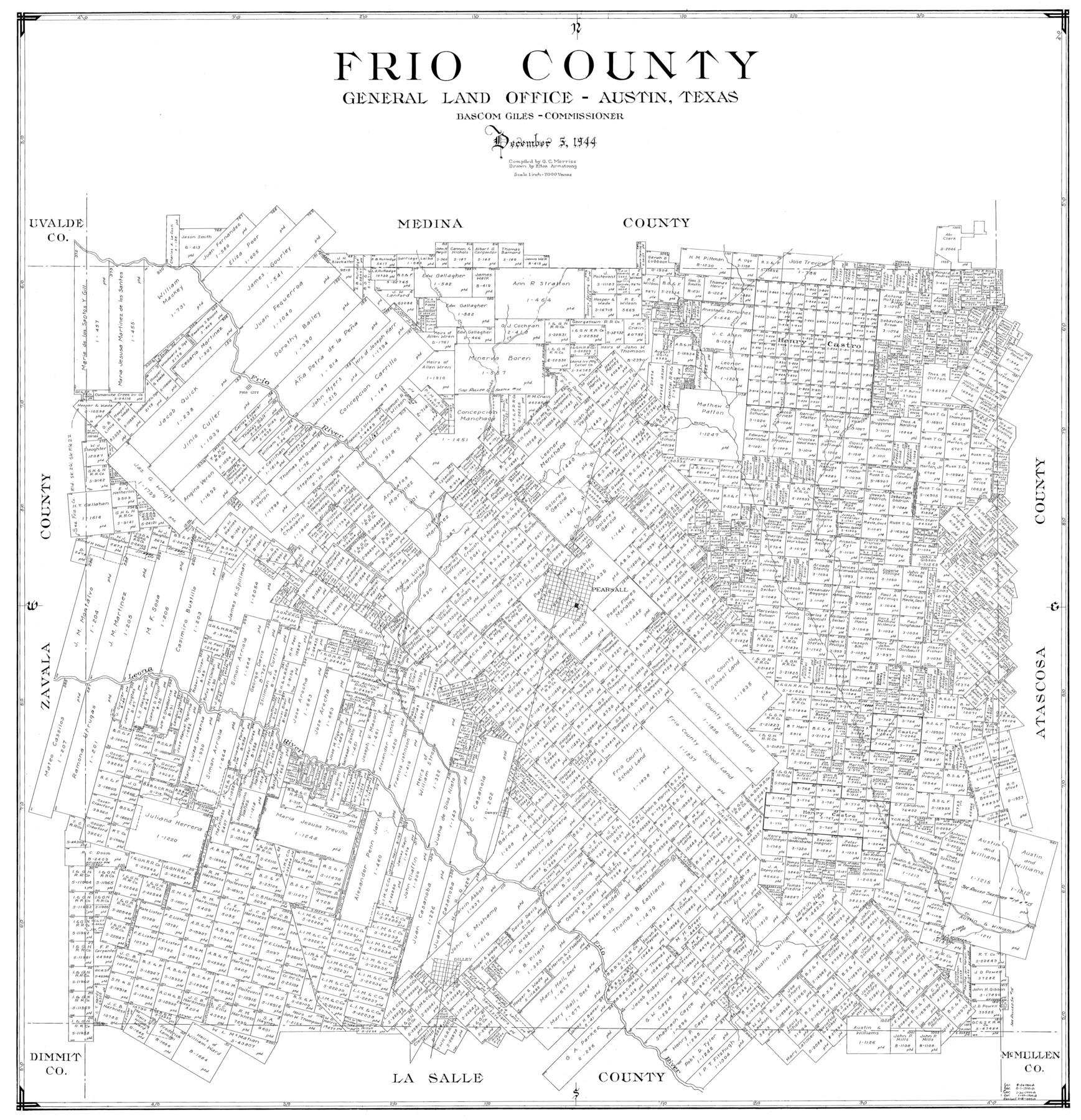
Frio County
-
Map/Doc
77285
-
Collection
General Map Collection
-
Object Dates
1944/12/5 (Creation Date)
-
People and Organizations
Eltea Armstrong (Draftsman)
G.C. Morriss (Compiler)
-
Counties
Frio
-
Subjects
County
-
Height x Width
39.7 x 38.3 inches
100.8 x 97.3 cm
Part of: General Map Collection
Map of Clay Co.

Print $40.00
- Digital $50.00
Map of Clay Co.
1896
Size 53.8 x 34.6 inches
Map/Doc 4910
Potter County

Print $20.00
- Digital $50.00
Potter County
1960
Size 43.5 x 35.6 inches
Map/Doc 95615

Shelby County Working Sketch 12

Print $40.00
- Digital $50.00
Shelby County Working Sketch 12
1946
Size 53.4 x 36.4 inches
Map/Doc 63865
Ector County Working Sketch 3

Print $20.00
- Digital $50.00
Ector County Working Sketch 3
1940
Size 26.4 x 31.2 inches
Map/Doc 68846
Jeff Davis County Working Sketch 40

Print $20.00
- Digital $50.00
Jeff Davis County Working Sketch 40
1981
Size 19.6 x 37.6 inches
Map/Doc 66535
Sulphur River, Bassett Sheet

Print $20.00
- Digital $50.00
Sulphur River, Bassett Sheet
1939
Size 24.8 x 32.0 inches
Map/Doc 78322
Hutchinson County Working Sketch 27

Print $20.00
- Digital $50.00
Hutchinson County Working Sketch 27
1978
Size 26.8 x 22.2 inches
Map/Doc 66387
Leon County Sketch File 31

Print $20.00
- Digital $50.00
Leon County Sketch File 31
Size 19.1 x 20.5 inches
Map/Doc 11993
Matagorda County Rolled Sketch 11

Print $40.00
- Digital $50.00
Matagorda County Rolled Sketch 11
Size 39.8 x 62.0 inches
Map/Doc 8348

Concho, San Saba & Llano Valley Railway, Sterling City Branch, Texas. Right of Way and Track Map

Print $40.00
- Digital $50.00
Concho, San Saba & Llano Valley Railway, Sterling City Branch, Texas. Right of Way and Track Map
1910
Size 17.7 x 57.8 inches
Map/Doc 64437
You may also like
Map of the City of Corsicana (Navarro County) Texas

Print $40.00
- Digital $50.00
Map of the City of Corsicana (Navarro County) Texas
1963
Size 40.1 x 91.8 inches
Map/Doc 93674
Treaty to Resolve Pending Boundary Differences and Maintain the Rio Grande and Colorado River as the International Boundary Between the United States of American and Mexico

Print $20.00
- Digital $50.00
Treaty to Resolve Pending Boundary Differences and Maintain the Rio Grande and Colorado River as the International Boundary Between the United States of American and Mexico
1970
Size 10.9 x 35.6 inches
Map/Doc 83104
[Sketch for Mineral Application 13439 - Old River, Walle Merritt]
![65688, [Sketch for Mineral Application 13439 - Old River, Walle Merritt], General Map Collection](https://historictexasmaps.com/wmedia_w700/maps/65688-1.tif.jpg)
Print $20.00
- Digital $50.00
[Sketch for Mineral Application 13439 - Old River, Walle Merritt]
1925
Size 41.2 x 18.9 inches
Map/Doc 65688
Limestone County Sketch File 5a

Print $6.00
- Digital $50.00
Limestone County Sketch File 5a
1858
Size 9.4 x 7.3 inches
Map/Doc 30164
Welch, Dawson County, Texas

Print $20.00
- Digital $50.00
Welch, Dawson County, Texas
Size 19.4 x 16.6 inches
Map/Doc 92592
San Jacinto County Rolled Sketch 14

Print $20.00
- Digital $50.00
San Jacinto County Rolled Sketch 14
1998
Size 25.8 x 37.2 inches
Map/Doc 7569
Tyler County Working Sketch 12

Print $20.00
- Digital $50.00
Tyler County Working Sketch 12
1942
Size 21.2 x 31.7 inches
Map/Doc 69482
Lubbock County Rolled Sketch 7

Print $20.00
- Digital $50.00
Lubbock County Rolled Sketch 7
1944
Size 25.8 x 32.9 inches
Map/Doc 6643
W. R. and J. M. Baggett's Ranch, Crockett County, Texas

Print $20.00
- Digital $50.00
W. R. and J. M. Baggett's Ranch, Crockett County, Texas
Size 22.8 x 25.5 inches
Map/Doc 92554
Polk County Sketch File 32

Print $8.00
- Digital $50.00
Polk County Sketch File 32
1887
Size 12.8 x 8.0 inches
Map/Doc 34226
[Abstract Numbering Register - Anderson through Dimmit]
![82965, [Abstract Numbering Register - Anderson through Dimmit], General Map Collection](https://historictexasmaps.com/wmedia_w700/pdf_converted_jpg/qi_pdf_thumbnail_30612.jpg)
[Abstract Numbering Register - Anderson through Dimmit]
Map/Doc 82965
Sketch T [showing Capitol Reserve]
![89631, Sketch T [showing Capitol Reserve], Twichell Survey Records](https://historictexasmaps.com/wmedia_w700/maps/89631-1.tif.jpg)
Print $40.00
- Digital $50.00
Sketch T [showing Capitol Reserve]
1903
Size 22.0 x 48.9 inches
Map/Doc 89631