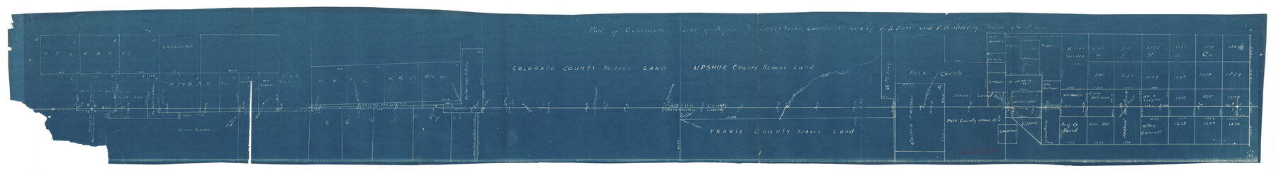
Plat of Common Line of Baylor and Throckmorton Counties as Run by A.D. Kerr and F.B. Stribling
224-1
-
Map/Doc
89640
-
Collection
Twichell Survey Records
-
Counties
Throckmorton
-
Height x Width
63.0 x 9.0 inches
160.0 x 22.9 cm
Part of: Twichell Survey Records
[Blocks 33-35, Township 5N]
![92029, [Blocks 33-35, Township 5N], Twichell Survey Records](https://historictexasmaps.com/wmedia_w700/maps/92029-1.tif.jpg)
Print $20.00
- Digital $50.00
[Blocks 33-35, Township 5N]
Size 37.4 x 23.8 inches
Map/Doc 92029
Suburban Homes Addition

Print $2.00
- Digital $50.00
Suburban Homes Addition
1926
Size 12.9 x 9.2 inches
Map/Doc 92263
[Pencil sketch showing blocks B17, B20-B28 and surrounding]
![89734, [Pencil sketch showing blocks B17, B20-B28 and surrounding], Twichell Survey Records](https://historictexasmaps.com/wmedia_w700/maps/89734-1.tif.jpg)
Print $40.00
- Digital $50.00
[Pencil sketch showing blocks B17, B20-B28 and surrounding]
Size 58.5 x 40.0 inches
Map/Doc 89734
Whitehead Addition, City of Lubbock

Print $20.00
- Digital $50.00
Whitehead Addition, City of Lubbock
Size 17.9 x 24.6 inches
Map/Doc 92779
Map of Stephens County, Texas

Print $20.00
- Digital $50.00
Map of Stephens County, Texas
Size 36.8 x 40.1 inches
Map/Doc 93026
Cogdell Ranch Kent County, Texas

Print $20.00
- Digital $50.00
Cogdell Ranch Kent County, Texas
1950
Size 24.8 x 13.5 inches
Map/Doc 92189
[Southwest Portion of Glasscock County]
![90765, [Southwest Portion of Glasscock County], Twichell Survey Records](https://historictexasmaps.com/wmedia_w700/maps/90765-1.tif.jpg)
Print $20.00
- Digital $50.00
[Southwest Portion of Glasscock County]
Size 18.7 x 20.9 inches
Map/Doc 90765
Cliffside Situated on Section 21, Block 9, Potter County, Texas

Print $2.00
- Digital $50.00
Cliffside Situated on Section 21, Block 9, Potter County, Texas
Size 5.9 x 10.6 inches
Map/Doc 92099
Plat of Fee Land Adjoining the Town of Lovington, New Mexico

Print $20.00
- Digital $50.00
Plat of Fee Land Adjoining the Town of Lovington, New Mexico
Size 24.2 x 18.4 inches
Map/Doc 92422
[T. & P. Block 44, Township 1S]
![90825, [T. & P. Block 44, Township 1S], Twichell Survey Records](https://historictexasmaps.com/wmedia_w700/maps/90825-2.tif.jpg)
Print $20.00
- Digital $50.00
[T. & P. Block 44, Township 1S]
Size 17.9 x 23.3 inches
Map/Doc 90825
[Blocks O3 and O4 and Capitol Leagues in the vicinity]
![90391, [Blocks O3 and O4 and Capitol Leagues in the vicinity], Twichell Survey Records](https://historictexasmaps.com/wmedia_w700/maps/90391-1.tif.jpg)
Print $2.00
- Digital $50.00
[Blocks O3 and O4 and Capitol Leagues in the vicinity]
Size 8.4 x 10.5 inches
Map/Doc 90391
Brazos River Conservation and Reclamation District Official Boundary Line Survey

Print $20.00
- Digital $50.00
Brazos River Conservation and Reclamation District Official Boundary Line Survey
1931
Size 25.1 x 36.9 inches
Map/Doc 90125
You may also like
Stonewall County Working Sketch 6

Print $20.00
- Digital $50.00
Stonewall County Working Sketch 6
1949
Size 16.5 x 30.1 inches
Map/Doc 62313
Travis County Working Sketch 41

Print $20.00
- Digital $50.00
Travis County Working Sketch 41
1974
Size 34.4 x 31.3 inches
Map/Doc 69425
Red River County Working Sketch 3

Print $20.00
- Digital $50.00
Red River County Working Sketch 3
1919
Size 14.2 x 12.8 inches
Map/Doc 71986
Reconnaissance Map, Roby Sheet

Print $20.00
- Digital $50.00
Reconnaissance Map, Roby Sheet
1893
Size 17.0 x 20.8 inches
Map/Doc 90869
Runnels County Rolled Sketch 41

Print $20.00
- Digital $50.00
Runnels County Rolled Sketch 41
Size 26.1 x 29.8 inches
Map/Doc 7529
Hale County Working Sketch 3

Print $20.00
- Digital $50.00
Hale County Working Sketch 3
1963
Size 27.0 x 22.2 inches
Map/Doc 63323
Bastrop County Sketch File 2

Print $4.00
- Digital $50.00
Bastrop County Sketch File 2
1858
Size 10.8 x 8.3 inches
Map/Doc 14042
Sutton County Sketch File 62

Print $4.00
- Digital $50.00
Sutton County Sketch File 62
1959
Size 3.7 x 8.6 inches
Map/Doc 37564
[Sketch for Mineral Application 13271- Trinity River]
![65627, [Sketch for Mineral Application 13271- Trinity River], General Map Collection](https://historictexasmaps.com/wmedia_w700/maps/65627.tif.jpg)
Print $40.00
- Digital $50.00
[Sketch for Mineral Application 13271- Trinity River]
1925
Size 63.4 x 25.0 inches
Map/Doc 65627
Callahan County Sketch File 10 1/2

Print $4.00
- Digital $50.00
Callahan County Sketch File 10 1/2
1889
Size 14.4 x 8.7 inches
Map/Doc 35885
Loving County Sketch File 8

Print $44.00
- Digital $50.00
Loving County Sketch File 8
2002
Size 11.2 x 8.7 inches
Map/Doc 76377
