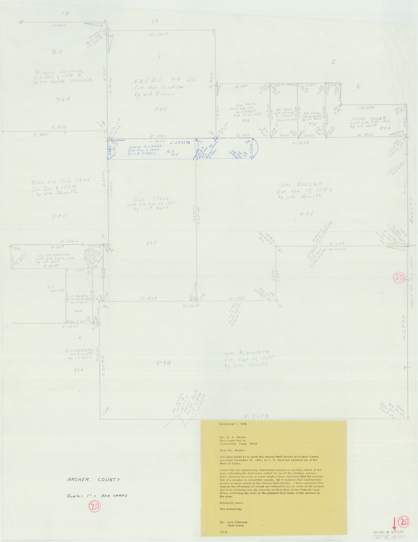
Archer County Working Sketch 20
-
Map/Doc
67161
-
Collection
General Map Collection
-
Object Dates
9/9/1975 (Creation Date)
-
People and Organizations
Bob Armstrong (GLO Commissioner)
-
Counties
Archer
-
Subjects
Surveying Working Sketch
-
Height x Width
31.7 x 24.4 inches
80.5 x 62.0 cm
-
Scale
1" = 300 varas
-
Comments
Surveys located about 13 miles South 55 degrees West of Archer City, Texas.
Part of: General Map Collection
[Map of the Location Survey of the Hearne & Brazos Valley Railroad]
![64348, [Map of the Location Survey of the Hearne & Brazos Valley Railroad], General Map Collection](https://historictexasmaps.com/wmedia_w700/maps/64348.tif.jpg)
Print $40.00
- Digital $50.00
[Map of the Location Survey of the Hearne & Brazos Valley Railroad]
1891
Size 38.4 x 65.1 inches
Map/Doc 64348
The Rand-McNally New Commercial Atlas Map of Texas

The Rand-McNally New Commercial Atlas Map of Texas
1914
Size 29.4 x 40.7 inches
Map/Doc 88745
Camp County Sketch File 1

Print $4.00
- Digital $50.00
Camp County Sketch File 1
Size 10.4 x 8.1 inches
Map/Doc 17333
Hartley County Sketch File 12

Print $20.00
- Digital $50.00
Hartley County Sketch File 12
1906
Size 16.3 x 12.4 inches
Map/Doc 11736
Flight Mission No. DQN-3K, Frame 67, Calhoun County

Print $20.00
- Digital $50.00
Flight Mission No. DQN-3K, Frame 67, Calhoun County
1953
Size 18.6 x 22.3 inches
Map/Doc 84358
Flight Mission No. CRC-2R, Frame 122, Chambers County

Print $20.00
- Digital $50.00
Flight Mission No. CRC-2R, Frame 122, Chambers County
1956
Size 18.9 x 22.5 inches
Map/Doc 84746
Zapata County Boundary File 1

Print $2.00
- Digital $50.00
Zapata County Boundary File 1
Size 11.4 x 9.0 inches
Map/Doc 60227
Coast Chart No. 209 - Aransas Pass, Aransas and Copano Bays, Texas

Print $20.00
- Digital $50.00
Coast Chart No. 209 - Aransas Pass, Aransas and Copano Bays, Texas
1906
Size 40.2 x 33.8 inches
Map/Doc 73430
Flight Mission No. DAH-17M, Frame 62, Orange County

Print $20.00
- Digital $50.00
Flight Mission No. DAH-17M, Frame 62, Orange County
1953
Size 18.5 x 22.6 inches
Map/Doc 86896
San Patricio County Sketch File 16

Print $4.00
San Patricio County Sketch File 16
1880
Size 12.9 x 8.0 inches
Map/Doc 36064
Presidio County Rolled Sketch 112

Print $20.00
- Digital $50.00
Presidio County Rolled Sketch 112
1972
Size 22.8 x 36.5 inches
Map/Doc 7388
Jack County Sketch File 3

Print $6.00
- Digital $50.00
Jack County Sketch File 3
1857
Size 10.6 x 16.5 inches
Map/Doc 27504
You may also like
The Rand-McNally New Commercial Atlas Map of Texas

Print $20.00
The Rand-McNally New Commercial Atlas Map of Texas
1914
Size 42.7 x 28.6 inches
Map/Doc 78226
Baylor County Rolled Sketch BT

Print $20.00
- Digital $50.00
Baylor County Rolled Sketch BT
1916
Size 21.4 x 24.0 inches
Map/Doc 5131
Llano County Sketch File 18

Print $20.00
- Digital $50.00
Llano County Sketch File 18
1949
Size 22.3 x 20.0 inches
Map/Doc 12013
Bell County Sketch File 25a

Print $4.00
- Digital $50.00
Bell County Sketch File 25a
1880
Size 8.9 x 10.9 inches
Map/Doc 14424
Working Sketch in Collingsworth County

Print $20.00
- Digital $50.00
Working Sketch in Collingsworth County
1910
Size 6.5 x 38.9 inches
Map/Doc 90728
Medina County Sketch File 13

Print $20.00
- Digital $50.00
Medina County Sketch File 13
Size 18.1 x 22.7 inches
Map/Doc 12069
Tarrant County Working Sketch 4

Print $20.00
- Digital $50.00
Tarrant County Working Sketch 4
1952
Size 20.6 x 19.7 inches
Map/Doc 62421
[Surveys in the Milam District]
![69729, [Surveys in the Milam District], General Map Collection](https://historictexasmaps.com/wmedia_w700/maps/69729.tif.jpg)
Print $2.00
- Digital $50.00
[Surveys in the Milam District]
1845
Size 9.5 x 6.7 inches
Map/Doc 69729
Hudspeth County Rolled Sketch 66

Print $20.00
- Digital $50.00
Hudspeth County Rolled Sketch 66
1973
Size 12.0 x 19.0 inches
Map/Doc 6262
Brewster County Working Sketch 2

Print $20.00
- Digital $50.00
Brewster County Working Sketch 2
1907
Size 29.0 x 26.4 inches
Map/Doc 67535
Aransas County Sketch File 14

Print $36.00
- Digital $50.00
Aransas County Sketch File 14
1891
Size 14.0 x 8.5 inches
Map/Doc 13128
Presidio County Working Sketch 14

Print $20.00
- Digital $50.00
Presidio County Working Sketch 14
1942
Size 10.9 x 17.7 inches
Map/Doc 71690