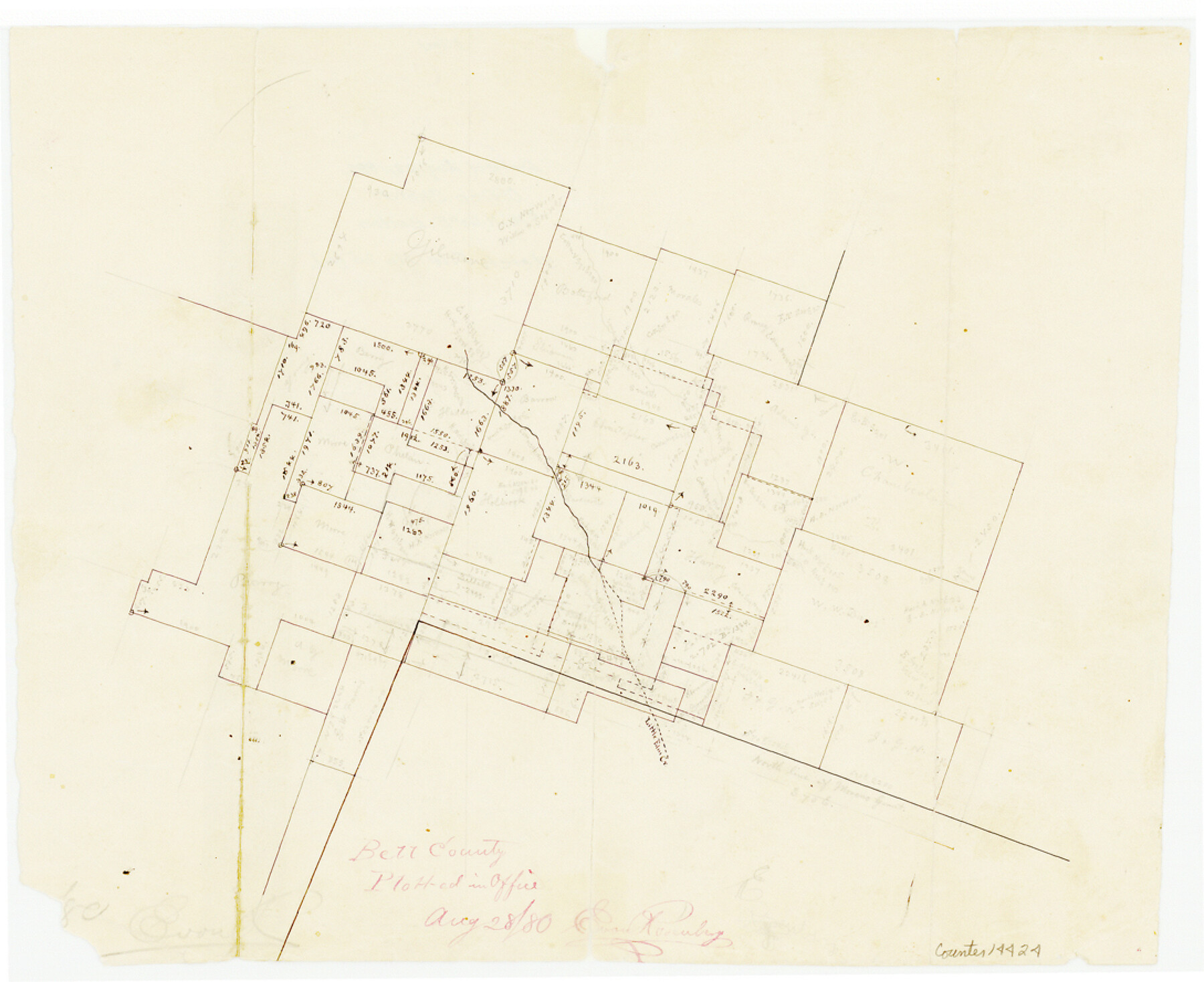
Bell County Sketch File 25a
[Office sketch of surveys northeast of Belton near Little Elm Creek]
-
Map/Doc
14424
-
Collection
General Map Collection
-
Object Dates
1880/8/28 (Creation Date)
-
People and Organizations
E. von Rosenberg (Draftsman)
-
Counties
Bell
-
Subjects
Surveying Sketch File
-
Height x Width
8.9 x 10.9 inches
22.6 x 27.7 cm
-
Medium
paper, manuscript
-
Features
Little Elm Creek
Part of: General Map Collection
Live Oak County Rolled Sketch 10A

Print $20.00
- Digital $50.00
Live Oak County Rolled Sketch 10A
1983
Size 38.4 x 43.6 inches
Map/Doc 9457
Hall County Sketch File 33

Print $16.00
- Digital $50.00
Hall County Sketch File 33
1912
Size 11.4 x 8.7 inches
Map/Doc 24874
Andrews County Working Sketch 30

Print $40.00
- Digital $50.00
Andrews County Working Sketch 30
1989
Size 34.2 x 48.0 inches
Map/Doc 67076
Milam County Sketch File 2

Print $4.00
- Digital $50.00
Milam County Sketch File 2
1849
Size 8.0 x 12.4 inches
Map/Doc 31627
Aransas County Rolled Sketch 16

Digital $50.00
Aransas County Rolled Sketch 16
Size 44.1 x 92.5 inches
Map/Doc 8412
Burnet County Rolled Sketch 6

Print $40.00
- Digital $50.00
Burnet County Rolled Sketch 6
1971
Size 36.4 x 49.5 inches
Map/Doc 8543
Eastland County Working Sketch 12

Print $20.00
- Digital $50.00
Eastland County Working Sketch 12
1919
Size 23.8 x 21.1 inches
Map/Doc 68793
Kaufman County Sketch File 3

Print $20.00
- Digital $50.00
Kaufman County Sketch File 3
1857
Size 25.3 x 18.7 inches
Map/Doc 4856
Cooke County Working Sketch 4

Print $20.00
- Digital $50.00
Cooke County Working Sketch 4
1926
Size 23.5 x 17.6 inches
Map/Doc 68241

Flight Mission No. BRA-7M, Frame 14, Jefferson County

Print $20.00
- Digital $50.00
Flight Mission No. BRA-7M, Frame 14, Jefferson County
1953
Size 18.6 x 22.3 inches
Map/Doc 85465
Crockett County Rolled Sketch 77

Print $20.00
- Digital $50.00
Crockett County Rolled Sketch 77
1952
Size 26.9 x 28.6 inches
Map/Doc 5618
You may also like
Blanco County Working Sketch 41

Print $20.00
- Digital $50.00
Blanco County Working Sketch 41
1986
Size 28.4 x 25.2 inches
Map/Doc 67401
General Highway Map, Franklin County, Morris County, Titus County, Camp County

Print $20.00
General Highway Map, Franklin County, Morris County, Titus County, Camp County
1940
Size 18.4 x 25.1 inches
Map/Doc 79040
Karnes County

Print $20.00
- Digital $50.00
Karnes County
1921
Size 44.3 x 39.6 inches
Map/Doc 95551
Culberson County Rolled Sketch 19

Print $20.00
- Digital $50.00
Culberson County Rolled Sketch 19
Size 18.8 x 29.4 inches
Map/Doc 5651
Taylor County Sketch File 2

Print $20.00
- Digital $50.00
Taylor County Sketch File 2
Size 13.8 x 18.4 inches
Map/Doc 12408
Leon County Sketch File 35-2

Print $20.00
- Digital $50.00
Leon County Sketch File 35-2
1966
Size 24.3 x 20.4 inches
Map/Doc 11994
Red River County

Print $20.00
- Digital $50.00
Red River County
1934
Size 45.0 x 38.6 inches
Map/Doc 77405
Motley County Sketch File 3A (N)

Print $20.00
- Digital $50.00
Motley County Sketch File 3A (N)
Size 12.3 x 17.5 inches
Map/Doc 42136
Kimble County Boundary File 3a

Print $36.00
- Digital $50.00
Kimble County Boundary File 3a
Size 8.8 x 8.2 inches
Map/Doc 64859
Marion County Working Sketch 46

Print $20.00
- Digital $50.00
Marion County Working Sketch 46
2011
Size 21.4 x 29.1 inches
Map/Doc 90032
Lampasas County Sketch File A1

Print $2.00
- Digital $50.00
Lampasas County Sketch File A1
Size 6.8 x 6.3 inches
Map/Doc 29385
Kinney County Working Sketch 36

Print $20.00
- Digital $50.00
Kinney County Working Sketch 36
1966
Size 31.7 x 42.0 inches
Map/Doc 70218