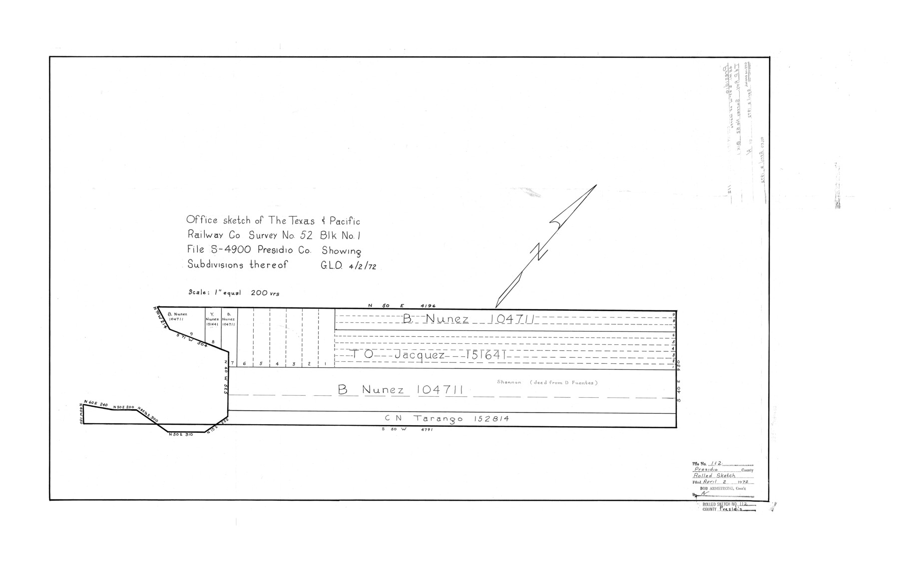
Presidio County Rolled Sketch 112
Office sketch of the Texas & Pacific Railway Co. survey no. 52, Blk. no. 1, file S-4900 Presidio Co. showing subdivisions thereof
-
Map/Doc
7388
-
Collection
General Map Collection
-
Object Dates
1972/4/2 (Creation Date)
1972/4/2 (File Date)
-
Counties
Presidio
-
Subjects
Surveying Rolled Sketch
-
Height x Width
22.8 x 36.5 inches
57.9 x 92.7 cm
-
Scale
1" = 200 varas
Part of: General Map Collection
Map of Asia engraved to illustrate Mitchell's school and family geography (Inset: Map of Palestine or the Holy Land)

Print $20.00
- Digital $50.00
Map of Asia engraved to illustrate Mitchell's school and family geography (Inset: Map of Palestine or the Holy Land)
1839
Size 9.5 x 11.8 inches
Map/Doc 93506
Anderson County

Print $40.00
- Digital $50.00
Anderson County
1942
Size 53.5 x 47.1 inches
Map/Doc 73066
Kinney County Rolled Sketch 1

Print $20.00
- Digital $50.00
Kinney County Rolled Sketch 1
Size 25.1 x 36.1 inches
Map/Doc 6533
Donley County Working Sketch 5

Print $40.00
- Digital $50.00
Donley County Working Sketch 5
1957
Size 54.8 x 32.2 inches
Map/Doc 62185
Rio Grande, Donna Sheet

Print $20.00
- Digital $50.00
Rio Grande, Donna Sheet
1937
Size 37.5 x 37.4 inches
Map/Doc 65117
Trinity River, Flagg Lake Sheet/Cedar Creek

Print $20.00
- Digital $50.00
Trinity River, Flagg Lake Sheet/Cedar Creek
1927
Size 37.4 x 30.7 inches
Map/Doc 65219
Brewster County Rolled Sketch 17

Print $40.00
- Digital $50.00
Brewster County Rolled Sketch 17
Size 25.1 x 63.4 inches
Map/Doc 5195
[Right of Way & Track Map, The Texas & Pacific Ry. Co. Main Line]
![64684, [Right of Way & Track Map, The Texas & Pacific Ry. Co. Main Line], General Map Collection](https://historictexasmaps.com/wmedia_w700/maps/64684.tif.jpg)
Print $20.00
- Digital $50.00
[Right of Way & Track Map, The Texas & Pacific Ry. Co. Main Line]
Size 11.0 x 19.0 inches
Map/Doc 64684
Outer Continental Shelf Leasing Maps (Louisiana Offshore Operations)

Print $20.00
- Digital $50.00
Outer Continental Shelf Leasing Maps (Louisiana Offshore Operations)
1955
Size 16.2 x 13.0 inches
Map/Doc 76084
Presidio County Working Sketch 28

Print $20.00
- Digital $50.00
Presidio County Working Sketch 28
1945
Size 19.9 x 13.4 inches
Map/Doc 71704
Presidio County Rolled Sketch 50

Print $20.00
- Digital $50.00
Presidio County Rolled Sketch 50
Size 21.2 x 18.4 inches
Map/Doc 7344
Clay County Sketch File 15

Print $4.00
- Digital $50.00
Clay County Sketch File 15
1873
Size 12.8 x 8.4 inches
Map/Doc 18419
You may also like
Flight Mission No. BRE-2P, Frame 46, Nueces County

Print $20.00
- Digital $50.00
Flight Mission No. BRE-2P, Frame 46, Nueces County
1956
Size 18.7 x 22.7 inches
Map/Doc 86748
Bosque County Sketch File 32

Print $42.00
- Digital $50.00
Bosque County Sketch File 32
1944
Size 19.6 x 18.6 inches
Map/Doc 10938
Harris County Boundary File 39 (14)

Print $30.00
- Digital $50.00
Harris County Boundary File 39 (14)
Size 13.2 x 8.1 inches
Map/Doc 54344
Moore County Working Sketch 11

Print $20.00
- Digital $50.00
Moore County Working Sketch 11
1951
Size 33.1 x 29.8 inches
Map/Doc 71193
Willacy County Boundary File 1

Print $23.00
- Digital $50.00
Willacy County Boundary File 1
Size 11.3 x 8.8 inches
Map/Doc 59956
Fractional Township No. 7 South Range No. 15 East of the Indian Meridian, Indian Territory

Print $20.00
- Digital $50.00
Fractional Township No. 7 South Range No. 15 East of the Indian Meridian, Indian Territory
1896
Size 19.2 x 24.3 inches
Map/Doc 75226
Coke County Sketch File 22

Print $20.00
- Digital $50.00
Coke County Sketch File 22
1923
Size 22.1 x 27.8 inches
Map/Doc 11111
9th Street & Ave. A. Galveston, Texas showing beginning of jetty right of way, and seawall extension track

Print $20.00
- Digital $50.00
9th Street & Ave. A. Galveston, Texas showing beginning of jetty right of way, and seawall extension track
1920
Size 21.3 x 33.6 inches
Map/Doc 73630
Crosby County Working Sketch 2

Print $20.00
- Digital $50.00
Crosby County Working Sketch 2
Size 18.2 x 18.0 inches
Map/Doc 68436
Nueces County Rolled Sketch 19

Print $20.00
- Digital $50.00
Nueces County Rolled Sketch 19
1920
Size 22.5 x 32.7 inches
Map/Doc 6872
Sketches of Surveys in Jefferson County

Print $2.00
- Digital $50.00
Sketches of Surveys in Jefferson County
1841
Size 7.5 x 7.0 inches
Map/Doc 326
