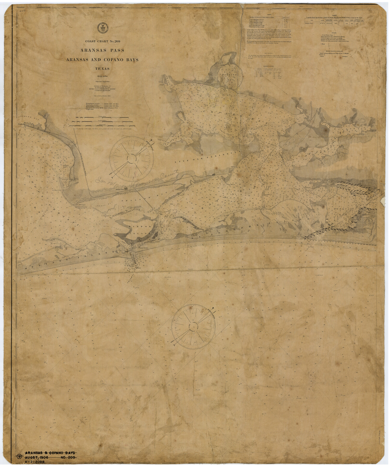
Coast Chart No. 209 - Aransas Pass, Aransas and Copano Bays, Texas
K-2-209a
-
Map/Doc
73430
-
Collection
General Map Collection
-
Object Dates
1906 (Creation Date)
-
Counties
Nueces San Patricio Aransas Refugio Calhoun
-
Subjects
Nautical Charts
-
Height x Width
40.2 x 33.8 inches
102.1 x 85.9 cm
Part of: General Map Collection
Flight Mission No. BRA-17M, Frame 4, Jefferson County

Print $20.00
- Digital $50.00
Flight Mission No. BRA-17M, Frame 4, Jefferson County
1953
Size 18.6 x 22.4 inches
Map/Doc 85784
Victoria County Sketch File 10

Print $4.00
- Digital $50.00
Victoria County Sketch File 10
1873
Size 10.1 x 8.4 inches
Map/Doc 39534
Liberty County Sketch File 8

Print $2.00
- Digital $50.00
Liberty County Sketch File 8
Size 8.3 x 10.1 inches
Map/Doc 29899
Right-of-Way Map Seawall Extension Galveston Island

Print $40.00
- Digital $50.00
Right-of-Way Map Seawall Extension Galveston Island
1958
Size 16.4 x 62.8 inches
Map/Doc 73617
Bell County Working Sketch 20

Print $20.00
- Digital $50.00
Bell County Working Sketch 20
1996
Size 39.5 x 34.7 inches
Map/Doc 67360
Flight Mission No. DAG-21K, Frame 34, Matagorda County

Print $20.00
- Digital $50.00
Flight Mission No. DAG-21K, Frame 34, Matagorda County
1952
Size 18.7 x 22.3 inches
Map/Doc 86401
Cooke County Sketch File 13

Print $20.00
- Digital $50.00
Cooke County Sketch File 13
1859
Size 27.1 x 19.0 inches
Map/Doc 11171
Amistad International Reservoir on Rio Grande 91

Print $20.00
- Digital $50.00
Amistad International Reservoir on Rio Grande 91
1950
Size 28.5 x 41.0 inches
Map/Doc 75521
Marion County Working Sketch 45

Print $20.00
- Digital $50.00
Marion County Working Sketch 45
2005
Size 27.0 x 29.2 inches
Map/Doc 83576
Galveston County Rolled Sketch 49

Print $20.00
- Digital $50.00
Galveston County Rolled Sketch 49
2018
Size 30.9 x 22.6 inches
Map/Doc 95386
Willacy County

Print $20.00
- Digital $50.00
Willacy County
1921
Size 25.2 x 32.2 inches
Map/Doc 73325
Matagorda County NRC Article 33.136 Sketch 7

Print $24.00
- Digital $50.00
Matagorda County NRC Article 33.136 Sketch 7
2010
Size 24.0 x 36.0 inches
Map/Doc 89997
You may also like
[Surveys in the Milam District Near the Upper San Gabriel River]
![247, [Surveys in the Milam District Near the Upper San Gabriel River], General Map Collection](https://historictexasmaps.com/wmedia_w700/maps/247.tif.jpg)
Print $20.00
- Digital $50.00
[Surveys in the Milam District Near the Upper San Gabriel River]
1845
Size 12.3 x 15.7 inches
Map/Doc 247
General Highway Map, Harrison County, Texas

Print $20.00
General Highway Map, Harrison County, Texas
1940
Size 18.2 x 24.8 inches
Map/Doc 79121
Dickens County Working Sketch 5b

Print $40.00
- Digital $50.00
Dickens County Working Sketch 5b
1917
Size 59.4 x 43.3 inches
Map/Doc 68653
Map of Caldwell County, Texas

Print $20.00
Map of Caldwell County, Texas
1879
Size 17.4 x 21.5 inches
Map/Doc 88914
[Worksheets related to the Wilson Strickland survey and vicinity]
![91381, [Worksheets related to the Wilson Strickland survey and vicinity], Twichell Survey Records](https://historictexasmaps.com/wmedia_w700/maps/91381-1.tif.jpg)
Print $20.00
- Digital $50.00
[Worksheets related to the Wilson Strickland survey and vicinity]
Size 20.1 x 24.8 inches
Map/Doc 91381
Jackson County Rolled Sketch 8

Print $20.00
- Digital $50.00
Jackson County Rolled Sketch 8
1938
Size 28.6 x 28.1 inches
Map/Doc 6343


Flight Mission No. DCL-6C, Frame 16, Kenedy County

Print $20.00
- Digital $50.00
Flight Mission No. DCL-6C, Frame 16, Kenedy County
1943
Size 18.7 x 22.3 inches
Map/Doc 85873

Foard County Aerial Photograph Index Sheet 4

Print $20.00
- Digital $50.00
Foard County Aerial Photograph Index Sheet 4
1950
Size 18.6 x 16.3 inches
Map/Doc 83691
Val Verde County Working Sketch 90

Print $40.00
- Digital $50.00
Val Verde County Working Sketch 90
1974
Size 49.1 x 32.9 inches
Map/Doc 72225