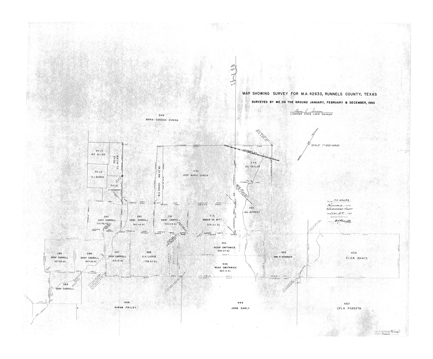
Runnels County Rolled Sketch 40
Map showing survey for MA-42633, Runnels County, Texas
- 
                          Map/Doc
7528
 - 
                            Collection
General Map Collection
 - 
                            Object Dates
1950 (Survey Date)
1951/1/3 (File Date)
 - 
                            People and Organizations
Byron L. Simpson (Surveyor/Engineer)
 - 
                            Counties
Runnels
 - 
                            Subjects
Surveying Rolled Sketch
 - 
                            Height x Width
32.3 x 38.9 inches
82.0 x 98.8 cm
 - 
                            Scale
1" = 500 varas
 
Part of: General Map Collection
            Controlled Mosaic by Jack Amman Photogrammetric Engineers, Inc - Sheet 20


                                            Print $20.00                    
                                             -                         Digital $50.00                                    
                Controlled Mosaic by Jack Amman Photogrammetric Engineers, Inc - Sheet 20
1954
Size 19.3 x 24.0 inches
                                Map/Doc 83469
            
            Gregg County Rolled Sketch 26


                                            Print $40.00                    
                                             -                         Digital $50.00                                    
                Gregg County Rolled Sketch 26
1937
Size 26.4 x 126.6 inches
                                Map/Doc 76432
            
            Map of Upshur County Showing Location T&P R.


                                            Print $20.00                    
                                             -                         Digital $50.00                                    
                Map of Upshur County Showing Location T&P R.
1872
Size 26.5 x 19.4 inches
                                Map/Doc 64137
            
            Bandera County Sketch File 19


                                            Print $40.00                    
                                             -                         Digital $50.00                                    
                Bandera County Sketch File 19
Size 15.9 x 18.9 inches
                                Map/Doc 10893
            
            Garza County Sketch File C1


                                            Print $10.00                    
                                             -                         Digital $50.00                                    
                Garza County Sketch File C1
1900
Size 12.9 x 8.1 inches
                                Map/Doc 24015
            
            [Cotton Belt, St. Louis Southwestern Railway of Texas, Alignment through Smith County]


                                            Print $20.00                    
                                             -                         Digital $50.00                                    
                [Cotton Belt, St. Louis Southwestern Railway of Texas, Alignment through Smith County]
1903
Size 21.7 x 30.0 inches
                                Map/Doc 64377
            
            Comanche County Working Sketch 4


                                            Print $40.00                    
                                             -                         Digital $50.00                                    
                Comanche County Working Sketch 4
1919
Size 58.7 x 35.2 inches
                                Map/Doc 68138
            
            Location Survey of the Southern Kansas Railway, Kiowa Extension from a point in Drake's Location, in Indian Territory 100 miles from south line of Kansas, continuing up Wolf Creek and South Canadian River to Cottonwood Creek in Hutchinson County


                                            Print $40.00                    
                                             -                         Digital $50.00                                    
                Location Survey of the Southern Kansas Railway, Kiowa Extension from a point in Drake's Location, in Indian Territory 100 miles from south line of Kansas, continuing up Wolf Creek and South Canadian River to Cottonwood Creek in Hutchinson County
1886
Size 37.5 x 282.7 inches
                                Map/Doc 88837
            
            Real County Working Sketch 67


                                            Print $4.00                    
                                             -                         Digital $50.00                                    
                Real County Working Sketch 67
1970
Size 21.2 x 16.4 inches
                                Map/Doc 71959
            
            Red River County Working Sketch 77


                                            Print $20.00                    
                                             -                         Digital $50.00                                    
                Red River County Working Sketch 77
1981
Size 34.9 x 23.8 inches
                                Map/Doc 72060
            
            Donley County Sketch File B4


                                            Print $20.00                    
                                             -                         Digital $50.00                                    
                Donley County Sketch File B4
1918
Size 33.3 x 21.8 inches
                                Map/Doc 11374
            
            Presidio County Sketch File 80


                                            Print $23.00                    
                                             -                         Digital $50.00                                    
                Presidio County Sketch File 80
1948
Size 9.5 x 20.3 inches
                                Map/Doc 34709
            You may also like
            Flight Mission No. BRE-5P, Frame 192, Nueces County


                                            Print $20.00                    
                                             -                         Digital $50.00                                    
                Flight Mission No. BRE-5P, Frame 192, Nueces County
1956
Size 18.4 x 22.3 inches
                                Map/Doc 86838
            
            Sulphur River and Cut Hand Creek, Hardison Lake Sheet


                                            Print $20.00                    
                                             -                         Digital $50.00                                    
                Sulphur River and Cut Hand Creek, Hardison Lake Sheet
1919
Size 22.5 x 24.2 inches
                                Map/Doc 65177
            
            Nueces County Rolled Sketch 134


                                            Print $20.00                    
                                             -                         Digital $50.00                                    
                Nueces County Rolled Sketch 134
2003
Size 24.9 x 36.6 inches
                                Map/Doc 81903
            
            Presidio County Working Sketch 118


                                            Print $20.00                    
                                             -                         Digital $50.00                                    
                Presidio County Working Sketch 118
1983
Size 47.4 x 41.6 inches
                                Map/Doc 71795
            
            Callahan County Sketch File 10


                                            Print $40.00                    
                                             -                         Digital $50.00                                    
                Callahan County Sketch File 10
Size 21.7 x 24.7 inches
                                Map/Doc 11039
            
            [Sketch Showing Wm. T. Brewer, John R. Taylor, Wm. F. Butler, Timothy DeVore, L. M. Thorn and adjoining surveys]


                                            Print $40.00                    
                                             -                         Digital $50.00                                    
                [Sketch Showing Wm. T. Brewer, John R. Taylor, Wm. F. Butler, Timothy DeVore, L. M. Thorn and adjoining surveys]
Size 37.1 x 56.1 inches
                                Map/Doc 89745
            
            Alamo Defenders Heritage Map of Texas


                                            Print $20.00                    
                                    
                Alamo Defenders Heritage Map of Texas
2025
Size 36.0 x 24.0 inches
                                Map/Doc 97433
            
            Preliminary Chart No. 31 of the Sea Coast of the United States from Galveston Bay to Matagorda Bay, Texas


                                            Print $20.00                    
                                             -                         Digital $50.00                                    
                Preliminary Chart No. 31 of the Sea Coast of the United States from Galveston Bay to Matagorda Bay, Texas
1857
Size 23.3 x 28.1 inches
                                Map/Doc 69950
            
            Garza County Working Sketch 14


                                            Print $20.00                    
                                             -                         Digital $50.00                                    
                Garza County Working Sketch 14
1957
Size 24.3 x 35.0 inches
                                Map/Doc 63161
            
            Polk County Boundary File 1


                                            Print $24.00                    
                                             -                         Digital $50.00                                    
                Polk County Boundary File 1
Size 12.6 x 8.0 inches
                                Map/Doc 57912
            
            Tyler County Sketch File 30


                                            Print $4.00                    
                                             -                         Digital $50.00                                    
                Tyler County Sketch File 30
1989
Size 14.3 x 8.8 inches
                                Map/Doc 38721
            
            General Highway Map, Menard County, Texas


                                            Print $20.00                    
                                    
                General Highway Map, Menard County, Texas
1940
Size 18.5 x 24.8 inches
                                Map/Doc 79196