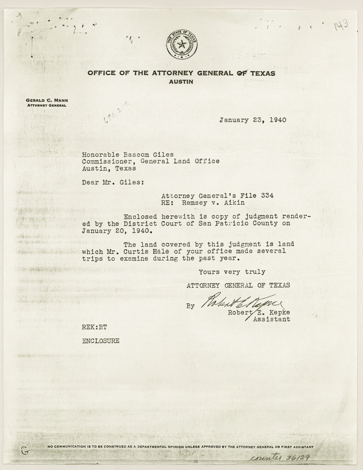
San Patricio County Sketch File 36
[Copy of judgement no. 4910 Mrs. Josephine Ramsey, et. al. vs. A.D. Aiken, et. al.]
-
Map/Doc
36129
-
Collection
General Map Collection
-
Object Dates
1/23/1940 (Creation Date)
3/15/1979 (File Date)
-
Counties
San Patricio
-
Subjects
Surveying Sketch File
-
Height x Width
11.3 x 8.7 inches
28.7 x 22.1 cm
-
Medium
photostat
-
Comments
See San Patricio County Rolled Sketch 39 (7725).
-
Features
Nueces Bay
Nueces River
Rincon Bayou
Related maps
San Patricio County Rolled Sketch 39

Print $20.00
- Digital $50.00
San Patricio County Rolled Sketch 39
1961
Size 40.4 x 31.7 inches
Map/Doc 7725
Part of: General Map Collection
Flight Mission No. CUG-1P, Frame 84, Kleberg County

Print $20.00
- Digital $50.00
Flight Mission No. CUG-1P, Frame 84, Kleberg County
1956
Size 18.4 x 22.3 inches
Map/Doc 86149
San Augustine Co.

Print $40.00
- Digital $50.00
San Augustine Co.
1949
Size 48.9 x 32.2 inches
Map/Doc 95632
Fannin County Working Sketch 1

Print $20.00
- Digital $50.00
Fannin County Working Sketch 1
1904
Size 27.6 x 19.5 inches
Map/Doc 69155
Presidio County Rolled Sketch 121

Print $40.00
- Digital $50.00
Presidio County Rolled Sketch 121
1939
Size 50.4 x 43.1 inches
Map/Doc 9797
Trinity County Sketch File 20

Print $20.00
- Digital $50.00
Trinity County Sketch File 20
Size 21.3 x 27.9 inches
Map/Doc 12485
King County Rolled Sketch 9

Print $20.00
- Digital $50.00
King County Rolled Sketch 9
Size 25.9 x 34.2 inches
Map/Doc 9350
Edwards County Working Sketch 61

Print $20.00
- Digital $50.00
Edwards County Working Sketch 61
1954
Size 21.0 x 40.3 inches
Map/Doc 68937
Motley County Sketch File 2 (S)

Print $20.00
- Digital $50.00
Motley County Sketch File 2 (S)
Size 31.1 x 25.1 inches
Map/Doc 42133
Flight Mission No. BRA-7M, Frame 130, Jefferson County

Print $20.00
- Digital $50.00
Flight Mission No. BRA-7M, Frame 130, Jefferson County
1953
Size 16.2 x 16.0 inches
Map/Doc 85524
Pottsboro Quadrangle

Print $20.00
- Digital $50.00
Pottsboro Quadrangle
1999
Size 35.4 x 23.4 inches
Map/Doc 97363
Wood County Working Sketch 6

Print $20.00
- Digital $50.00
Wood County Working Sketch 6
1941
Size 29.9 x 17.5 inches
Map/Doc 62006
Lubbock County Working Sketch 10

Print $20.00
- Digital $50.00
Lubbock County Working Sketch 10
1994
Size 21.8 x 30.1 inches
Map/Doc 70670
You may also like
Armstrong County Sketch File A-10

Print $40.00
- Digital $50.00
Armstrong County Sketch File A-10
Size 22.6 x 35.6 inches
Map/Doc 10852
Nautical Chart 518-SC: Galveston Bay Entrance

Print $20.00
- Digital $50.00
Nautical Chart 518-SC: Galveston Bay Entrance
1971
Size 19.2 x 19.1 inches
Map/Doc 75909
Galveston County Working Sketch 11

Print $20.00
- Digital $50.00
Galveston County Working Sketch 11
1967
Size 17.6 x 16.4 inches
Map/Doc 69348
Crane County Map of Unsurveyed School Lands for Bob Reid's Application to Lease

Print $40.00
- Digital $50.00
Crane County Map of Unsurveyed School Lands for Bob Reid's Application to Lease
1946
Size 49.0 x 51.3 inches
Map/Doc 90466
Hudspeth County Rolled Sketch 55

Print $49.00
- Digital $50.00
Hudspeth County Rolled Sketch 55
1977
Size 10.0 x 15.0 inches
Map/Doc 45968
The great railroad routes to the Pacific, and their connections

Print $20.00
- Digital $50.00
The great railroad routes to the Pacific, and their connections
1869
Size 16.3 x 29.4 inches
Map/Doc 96974
San Antonio and Aransas Pass Ry. from Survey Station 4852+100 to Survey Station 5280+00

Print $4.00
- Digital $50.00
San Antonio and Aransas Pass Ry. from Survey Station 4852+100 to Survey Station 5280+00
Size 11.8 x 18.6 inches
Map/Doc 62570
Nueces County Rolled Sketch 27A

Print $40.00
- Digital $50.00
Nueces County Rolled Sketch 27A
1946
Size 12.4 x 121.3 inches
Map/Doc 9597
Martin County

Print $20.00
- Digital $50.00
Martin County
1933
Size 43.8 x 38.9 inches
Map/Doc 73230
Crane County Sketch File 27

Print $6.00
- Digital $50.00
Crane County Sketch File 27
Size 11.5 x 9.3 inches
Map/Doc 19603
Brewster County Rolled Sketch 85

Print $20.00
- Digital $50.00
Brewster County Rolled Sketch 85
1946
Size 30.4 x 22.8 inches
Map/Doc 5246
[3KA and vicinity]
![90846, [3KA and vicinity], Twichell Survey Records](https://historictexasmaps.com/wmedia_w700/maps/90846-2.tif.jpg)
Print $20.00
- Digital $50.00
[3KA and vicinity]
Size 32.9 x 10.3 inches
Map/Doc 90846