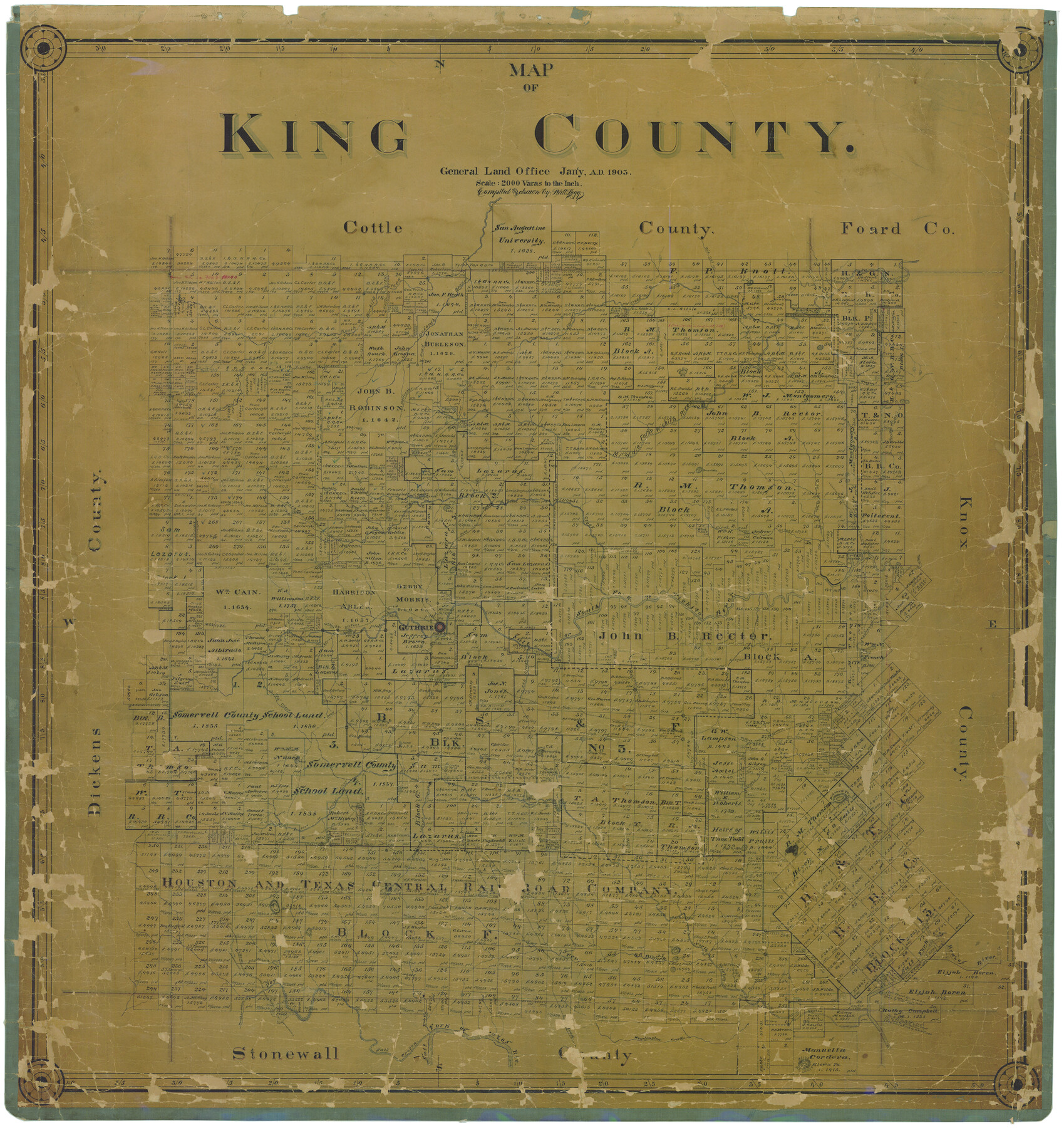
Map of King County
-
Map/Doc
16867
-
Collection
General Map Collection
-
Object Dates
1/1903 (Creation Date)
-
People and Organizations
J. Watt Legg (Draftsman)
-
Counties
King
-
Subjects
County
-
Height x Width
44.8 x 42.4 inches
113.8 x 107.7 cm
-
Features
McKenzie Trail
Guthrie Road
Saline Fork
Kiowa Peak
Benjamin Wagon Road
Brush Knob
Croton Creek
Guthrie and Benjamin Wagon Road
Dikes Creek
Newman Creek
Spring On Saline Fork
Quintilla Peaks
"Pa" Creek
Saline Creek
Tongue Mound
Brazos River
Guthrie
Ash Creek
Salt Fork of Wichita River
Road [from Salt Flats]
Old Mail Camp
Salt Croton [Creek]
Bob Creek
Weadington Creek
Mount Louisa
Mount Louisa
Pen Branch [of North Croton Creek]
Dove Creek
Panther Cañon
South Fork of Wichita River
North Croton River
Salt Fork of Brazos River
Gyp Creek
Flat Top Mountain
Jay Tank
Buzzard Peak
Little Croton Creek
Hackberry Creek
Paducah Road
Bitter Creek
Round Peak
Hay Rick Mountain
Middle Fork of Wichita River
Mason's Tank
Gibson's Tank
Road [from Gibson's Tank]
Fielder Branch of Middle Fork of Wichita River
Cottonwood Creek
Old Mail Camp
Farrer's Creek
Wagon Road
Pouring Spring
Military Road
Baby Creek
Tang Creek
Pole Cat Creek
Buford's Creek
Road [through Rocky Falls]
Spring Branch
Natural Bridge
Dutchman's Branch
Old McKenzie Trail
Dickens Road
Matador Road
Tank Creek
Rocky Falls
North Wichita Creek
Terrace Mountain
Rocky Falls
Willow Creek
Round Mountain
Bird's Creek
Ox Yoke Creek
Mail Creek
Spring Creek
Part of: General Map Collection
[Drawings of individual counties for Pressler and Langermann's 1879 Map of Texas]
![[Drawings of individual counties for Pressler and Langermann's 1879 Map of Texas]](https://historictexasmaps.com/wmedia_w700/maps/4863.tif.jpg)
Print $20.00
- Digital $50.00
[Drawings of individual counties for Pressler and Langermann's 1879 Map of Texas]
1878
Size 38.8 x 26.8 inches
Map/Doc 4863
Collin County Boundary File 18c

Print $12.00
- Digital $50.00
Collin County Boundary File 18c
Size 12.9 x 8.1 inches
Map/Doc 51733
Flight Mission No. DAG-17K, Frame 124, Matagorda County

Print $20.00
- Digital $50.00
Flight Mission No. DAG-17K, Frame 124, Matagorda County
1952
Size 18.6 x 22.3 inches
Map/Doc 86344
Liberty County Sketch File 6

Print $6.00
- Digital $50.00
Liberty County Sketch File 6
1856
Size 12.1 x 7.7 inches
Map/Doc 29893

Marion County Sketch File 19

Print $20.00
- Digital $50.00
Marion County Sketch File 19
2001
Size 11.2 x 8.8 inches
Map/Doc 30616
Kaufman County Sketch File 5

Print $22.00
- Digital $50.00
Kaufman County Sketch File 5
1849
Size 7.6 x 12.6 inches
Map/Doc 28632
Upshur County Working Sketch 11

Print $20.00
- Digital $50.00
Upshur County Working Sketch 11
1976
Size 43.4 x 43.2 inches
Map/Doc 69568
Gulf Intracoastal Waterway - Tributary Channel to Aransas Pass, Location of Spoil Disposal Areas

Print $20.00
- Digital $50.00
Gulf Intracoastal Waterway - Tributary Channel to Aransas Pass, Location of Spoil Disposal Areas
1961
Size 31.5 x 41.9 inches
Map/Doc 61828
Stephens County Boundary File 4

Print $6.00
- Digital $50.00
Stephens County Boundary File 4
Size 14.3 x 8.8 inches
Map/Doc 58894
Jack County Sketch File 5

Print $6.00
- Digital $50.00
Jack County Sketch File 5
1875
Size 11.0 x 10.8 inches
Map/Doc 27508
McCulloch County Rolled Sketch 8

Print $40.00
- Digital $50.00
McCulloch County Rolled Sketch 8
1982
Size 51.3 x 31.4 inches
Map/Doc 10292
You may also like
Wilson County Rolled Sketch 3

Print $20.00
- Digital $50.00
Wilson County Rolled Sketch 3
1956
Size 25.8 x 22.8 inches
Map/Doc 8369
Tom Green County Sketch File 38

Print $20.00
- Digital $50.00
Tom Green County Sketch File 38
Size 13.7 x 23.0 inches
Map/Doc 12438
Coke County Rolled Sketch 23

Print $20.00
- Digital $50.00
Coke County Rolled Sketch 23
1944
Size 13.7 x 14.7 inches
Map/Doc 5524
Sabine and Neches Rivers

Print $20.00
- Digital $50.00
Sabine and Neches Rivers
1925
Size 19.6 x 44.0 inches
Map/Doc 69816
[Blocks M-21, Z, and E. L. & RR. Block L]
![91151, [Blocks M-21, Z, and E. L. & RR. Block L], Twichell Survey Records](https://historictexasmaps.com/wmedia_w700/maps/91151-1.tif.jpg)
Print $20.00
- Digital $50.00
[Blocks M-21, Z, and E. L. & RR. Block L]
Size 14.5 x 17.9 inches
Map/Doc 91151
Kerr County Rolled Sketch 8 and 9

Print $40.00
- Digital $50.00
Kerr County Rolled Sketch 8 and 9
Size 56.3 x 37.9 inches
Map/Doc 8346

General Highway Map. Detail of Cities and Towns in Taylor County, Texas [Abilene and vicinity]
![79673, General Highway Map. Detail of Cities and Towns in Taylor County, Texas [Abilene and vicinity], Texas State Library and Archives](https://historictexasmaps.com/wmedia_w700/maps/79673.tif.jpg)
Print $20.00
General Highway Map. Detail of Cities and Towns in Taylor County, Texas [Abilene and vicinity]
1961
Size 18.2 x 24.8 inches
Map/Doc 79673
Bosque County Sketch File 6

Print $4.00
- Digital $50.00
Bosque County Sketch File 6
1851
Size 12.1 x 7.6 inches
Map/Doc 14748
[Leagues 11 and 22]
![91111, [Leagues 11 and 22], Twichell Survey Records](https://historictexasmaps.com/wmedia_w700/maps/91111-1.tif.jpg)
Print $20.00
- Digital $50.00
[Leagues 11 and 22]
1925
Size 14.0 x 13.6 inches
Map/Doc 91111
Lampasas County Sketch File 16 1/2

Print $4.00
- Digital $50.00
Lampasas County Sketch File 16 1/2
Size 8.4 x 8.6 inches
Map/Doc 29428
Fisher County Sketch File 6a

Print $20.00
- Digital $50.00
Fisher County Sketch File 6a
Size 21.3 x 18.1 inches
Map/Doc 11476