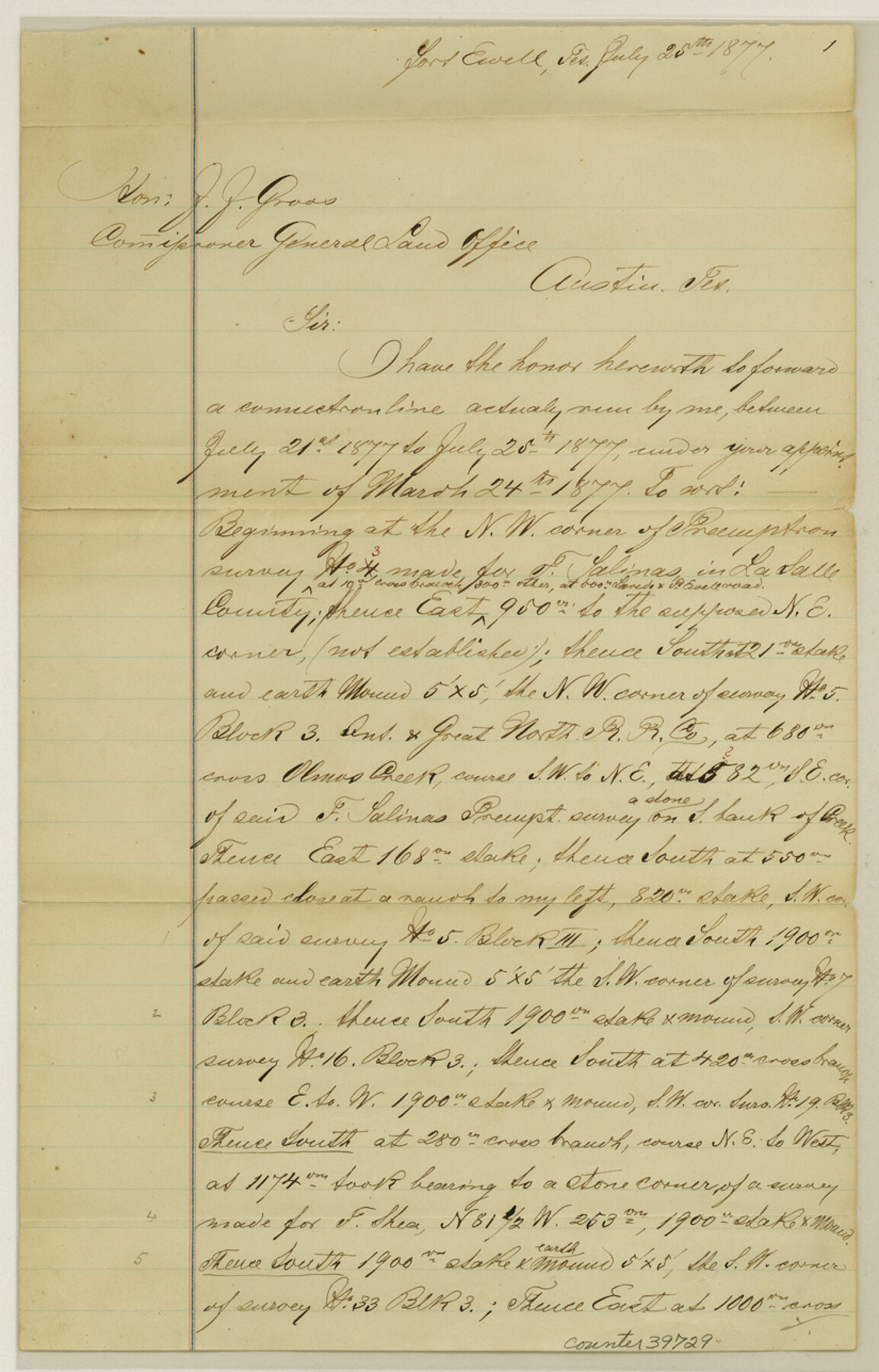
Webb County Sketch File 5a
[Connecting line between I. & G. N. R.R. Co. surveys and Nido waterhole]
-
Map/Doc
39729
-
Collection
General Map Collection
-
Object Dates
7/25/1877 (Creation Date)
8/1/1877 (File Date)
-
People and Organizations
A. Wyschetzki (Surveyor/Engineer)
-
Counties
Webb
-
Subjects
Surveying Sketch File
-
Height x Width
12.9 x 8.2 inches
32.8 x 20.8 cm
-
Medium
paper, manuscript
-
Features
Road from Fort Ewell to Laredo
Olmos Creek
Part of: General Map Collection
Crane County Boundary File 1a

Print $18.00
- Digital $50.00
Crane County Boundary File 1a
Size 14.2 x 8.7 inches
Map/Doc 51960
Harris County Working Sketch 28

Print $20.00
- Digital $50.00
Harris County Working Sketch 28
Size 34.4 x 43.1 inches
Map/Doc 65920
Deaf Smith County Rolled Sketch 1

Print $20.00
- Digital $50.00
Deaf Smith County Rolled Sketch 1
1965
Size 24.8 x 25.9 inches
Map/Doc 5698
Bexar County Sketch File 44

Print $5.00
- Digital $50.00
Bexar County Sketch File 44
1844
Size 15.7 x 9.3 inches
Map/Doc 14524
San Patricio County Sketch File 34

Print $4.00
- Digital $50.00
San Patricio County Sketch File 34
1961
Size 11.4 x 8.8 inches
Map/Doc 36119
Edwards County Working Sketch 91

Print $40.00
- Digital $50.00
Edwards County Working Sketch 91
1966
Size 34.8 x 51.1 inches
Map/Doc 68967
Runnels County Sketch File 36

Print $20.00
Runnels County Sketch File 36
1889
Size 20.9 x 19.6 inches
Map/Doc 12267
Blanco County Sketch File 27

Print $6.00
- Digital $50.00
Blanco County Sketch File 27
1888
Size 14.1 x 11.2 inches
Map/Doc 14621
Donley County Rolled Sketch 2

Print $20.00
- Digital $50.00
Donley County Rolled Sketch 2
Size 41.8 x 34.3 inches
Map/Doc 8800
Maps of Gulf Intracoastal Waterway, Texas - Sabine River to the Rio Grande and connecting waterways including ship channels

Print $20.00
- Digital $50.00
Maps of Gulf Intracoastal Waterway, Texas - Sabine River to the Rio Grande and connecting waterways including ship channels
1966
Size 14.5 x 22.2 inches
Map/Doc 61919
Edwards County Rolled Sketch 17

Print $20.00
- Digital $50.00
Edwards County Rolled Sketch 17
1945
Size 27.6 x 19.4 inches
Map/Doc 5806
Reeves County

Print $20.00
- Digital $50.00
Reeves County
1903
Size 47.3 x 35.6 inches
Map/Doc 66997
You may also like
Map showing Alamo-Donna Farms, Irrigated Section in Hidalgo County, Texas

Print $20.00
- Digital $50.00
Map showing Alamo-Donna Farms, Irrigated Section in Hidalgo County, Texas
1920
Size 27.5 x 13.3 inches
Map/Doc 95803
Flight Mission No. DAG-23K, Frame 144, Matagorda County

Print $20.00
- Digital $50.00
Flight Mission No. DAG-23K, Frame 144, Matagorda County
1953
Size 17.4 x 22.6 inches
Map/Doc 86492
Terrell County Sketch File 4

Print $12.00
- Digital $50.00
Terrell County Sketch File 4
1881
Map/Doc 12417
Flight Mission No. CRC-4R, Frame 73, Chambers County

Print $20.00
- Digital $50.00
Flight Mission No. CRC-4R, Frame 73, Chambers County
1956
Size 18.7 x 22.5 inches
Map/Doc 84877
Oldham County

Print $40.00
- Digital $50.00
Oldham County
1925
Size 41.5 x 53.2 inches
Map/Doc 95604
San Patricio County Sketch File 27

Print $4.00
San Patricio County Sketch File 27
Size 14.5 x 8.8 inches
Map/Doc 36085
Current Miscellaneous File 5

Print $8.00
- Digital $50.00
Current Miscellaneous File 5
1946
Size 11.3 x 8.8 inches
Map/Doc 73727
Flight Mission No. BRA-7M, Frame 18, Jefferson County

Print $20.00
- Digital $50.00
Flight Mission No. BRA-7M, Frame 18, Jefferson County
1953
Size 18.5 x 22.3 inches
Map/Doc 85469
Kendall County Working Sketch 17

Print $20.00
- Digital $50.00
Kendall County Working Sketch 17
1968
Size 31.0 x 30.9 inches
Map/Doc 66689
Flight Mission No. CLL-3N, Frame 37, Willacy County

Print $20.00
- Digital $50.00
Flight Mission No. CLL-3N, Frame 37, Willacy County
1954
Size 18.6 x 22.2 inches
Map/Doc 87095
Denton County Working Sketch 33

Print $20.00
- Digital $50.00
Denton County Working Sketch 33
2002
Size 35.3 x 46.1 inches
Map/Doc 78203
Fisher County Sketch File 7

Print $4.00
- Digital $50.00
Fisher County Sketch File 7
1893
Size 14.6 x 9.1 inches
Map/Doc 22565