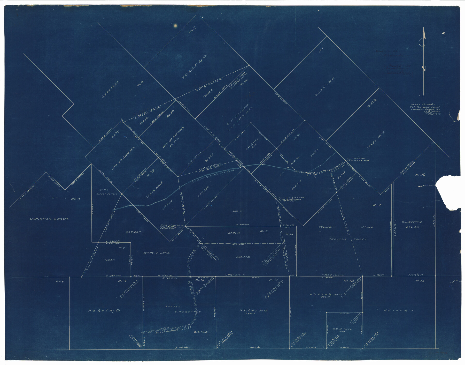
Edwards County Rolled Sketch 20
S.H. Guthrie Ranch
-
Map/Doc
8844
-
Collection
General Map Collection
-
Object Dates
1947/3/20 (Creation Date)
1948/3/3 (File Date)
-
People and Organizations
A.G. Farmer (Surveyor/Engineer)
-
Counties
Edwards
-
Subjects
Surveying Rolled Sketch
-
Height x Width
31.6 x 40.4 inches
80.3 x 102.6 cm
-
Medium
blueprint/diazo
-
Scale
1" = 300 varas
Part of: General Map Collection

Kaufman County Boundary File 1

Print $8.00
- Digital $50.00
Kaufman County Boundary File 1
Size 7.7 x 3.6 inches
Map/Doc 55903
Galveston County Working Sketch 2

Print $20.00
- Digital $50.00
Galveston County Working Sketch 2
1924
Size 24.1 x 26.3 inches
Map/Doc 69339
Flight Mission No. BQR-9K, Frame 50, Brazoria County

Print $20.00
- Digital $50.00
Flight Mission No. BQR-9K, Frame 50, Brazoria County
1952
Size 18.7 x 22.4 inches
Map/Doc 84054
Leon County Boundary File 1

Print $34.00
- Digital $50.00
Leon County Boundary File 1
Size 21.0 x 6.6 inches
Map/Doc 56281
Flight Mission No. DAG-18K, Frame 187, Matagorda County

Print $20.00
- Digital $50.00
Flight Mission No. DAG-18K, Frame 187, Matagorda County
1952
Size 16.2 x 15.8 inches
Map/Doc 86379
Flight Mission No. BRA-16M, Frame 58, Jefferson County

Print $20.00
- Digital $50.00
Flight Mission No. BRA-16M, Frame 58, Jefferson County
1953
Size 18.4 x 22.5 inches
Map/Doc 85675
No. 2 Chart of Corpus Christi Pass, Texas

Print $20.00
- Digital $50.00
No. 2 Chart of Corpus Christi Pass, Texas
1878
Size 18.4 x 27.3 inches
Map/Doc 73016
Tom Green County Sketch File 14

Print $20.00
- Digital $50.00
Tom Green County Sketch File 14
Size 34.8 x 45.7 inches
Map/Doc 10401
Bailey County Rolled Sketch 7

Print $40.00
- Digital $50.00
Bailey County Rolled Sketch 7
1941
Size 67.7 x 44.8 inches
Map/Doc 8438
Brazoria County Rolled Sketch 49

Print $20.00
- Digital $50.00
Brazoria County Rolled Sketch 49
1948
Size 23.8 x 36.2 inches
Map/Doc 5184
Map of the Lands Surveyed by the Memphis, El Paso & Pacific R.R. Company

Print $20.00
- Digital $50.00
Map of the Lands Surveyed by the Memphis, El Paso & Pacific R.R. Company
1859
Size 13.9 x 21.3 inches
Map/Doc 4849
You may also like
Roberts County Rolled Sketch 5

Print $20.00
- Digital $50.00
Roberts County Rolled Sketch 5
2015
Size 42.6 x 25.0 inches
Map/Doc 94071

Travis County Sketch File 29

Print $20.00
- Digital $50.00
Travis County Sketch File 29
1880
Size 12.3 x 21.8 inches
Map/Doc 12459
Newton County Sketch File 6

Print $4.00
- Digital $50.00
Newton County Sketch File 6
1872
Size 12.4 x 7.9 inches
Map/Doc 32372
Hardeman County Rolled Sketch 22

Print $20.00
- Digital $50.00
Hardeman County Rolled Sketch 22
Size 25.8 x 18.6 inches
Map/Doc 6073
Gulf of Mexico

Print $20.00
- Digital $50.00
Gulf of Mexico
1946
Size 36.2 x 43.7 inches
Map/Doc 73550
![90772, [Block XR], Twichell Survey Records](https://historictexasmaps.com/wmedia_w700/maps/90772-1.tif.jpg)
Liberty County Working Sketch 67

Print $20.00
- Digital $50.00
Liberty County Working Sketch 67
1971
Size 35.3 x 44.5 inches
Map/Doc 70527
Montague County Sketch File 1

Print $40.00
- Digital $50.00
Montague County Sketch File 1
1852
Size 19.4 x 12.4 inches
Map/Doc 31709
The Land Offices. No. 9, Gonzales, December 22, 1836

Print $20.00
The Land Offices. No. 9, Gonzales, December 22, 1836
2020
Size 22.3 x 21.7 inches
Map/Doc 96422
Cass County Working Sketch 48

Print $20.00
- Digital $50.00
Cass County Working Sketch 48
1992
Size 21.3 x 36.4 inches
Map/Doc 67951
Cameron County Rolled Sketch 20D

Print $20.00
- Digital $50.00
Cameron County Rolled Sketch 20D
Size 13.7 x 12.1 inches
Map/Doc 5476