Nueces County Rolled Sketch 113B
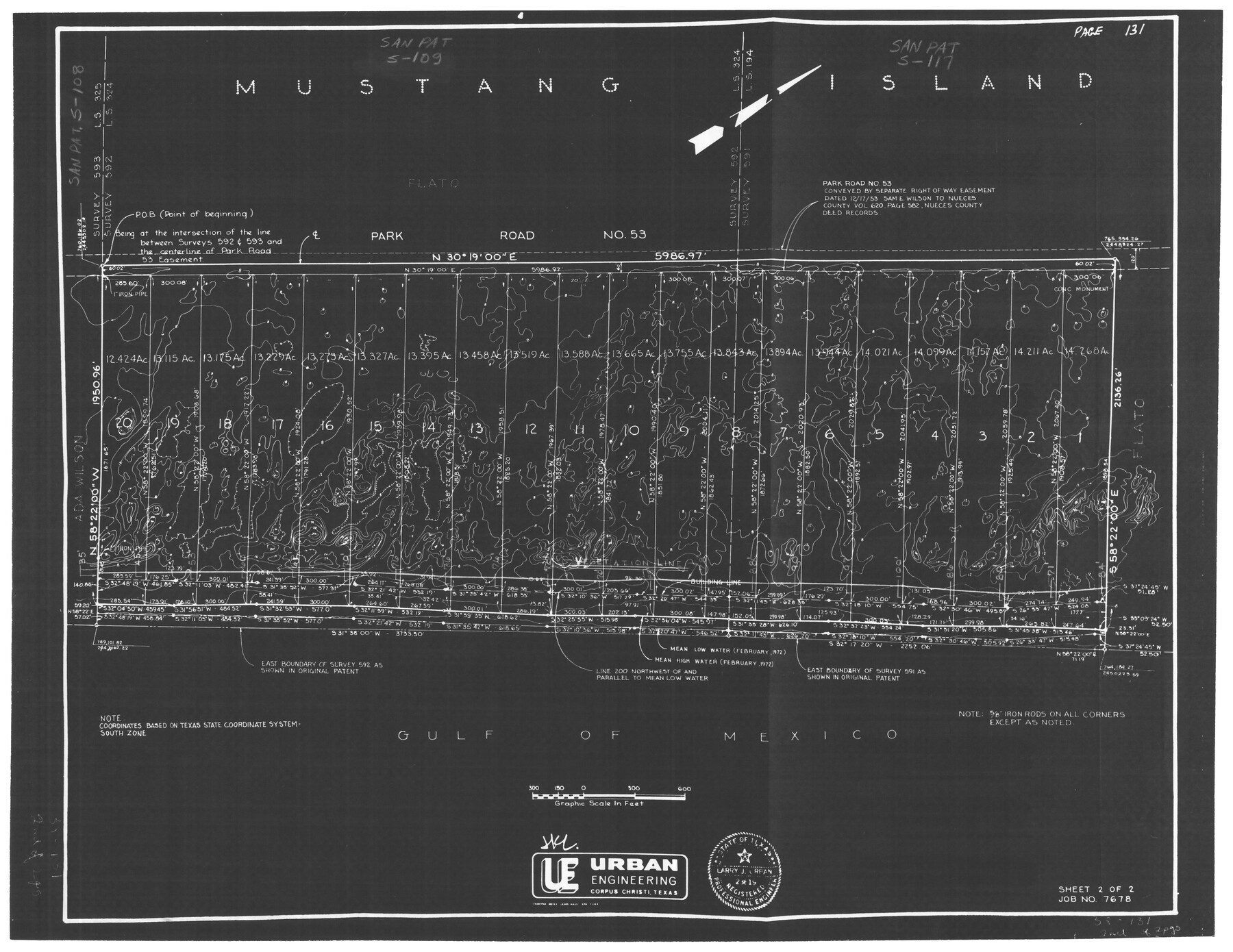
[Plat for Mustang Island being a 280.605 acre tract of land more or less out of survey 591, land script no. 194 & survey 592, land script no. 324, Mustang Island, Nueces County, Texas]
-
Map/Doc
7124
-
Collection
General Map Collection
-
Object Dates
4/28/1972 (Creation Date)
11/7/1991 (File Date)
-
People and Organizations
Larry J. Urban (Surveyor/Engineer)
-
Counties
Nueces
-
Subjects
Surveying Rolled Sketch
-
Height x Width
18.3 x 23.6 inches
46.5 x 59.9 cm
-
Medium
photostat
-
Comments
Sheet 2 of 2. See Nueces County Rolled Sketch 113B (7123) for sheet 1. Filed for information only.
Related maps
Nueces County Rolled Sketch 113B

Print $20.00
- Digital $50.00
Nueces County Rolled Sketch 113B
1972
Size 18.6 x 24.2 inches
Map/Doc 7123
Part of: General Map Collection
Terrell County Working Sketch 4

Print $20.00
- Digital $50.00
Terrell County Working Sketch 4
1914
Size 22.1 x 22.3 inches
Map/Doc 62153
Brewster County Rolled Sketch 113

Print $171.00
- Digital $50.00
Brewster County Rolled Sketch 113
1975
Map/Doc 9565
South Part Crockett County

Print $40.00
- Digital $50.00
South Part Crockett County
1977
Size 39.7 x 51.4 inches
Map/Doc 73122
Erath County Working Sketch 27

Print $20.00
- Digital $50.00
Erath County Working Sketch 27
1970
Size 26.6 x 24.0 inches
Map/Doc 69108
Travis County Rolled Sketch 16

Print $20.00
- Digital $50.00
Travis County Rolled Sketch 16
1940
Size 21.0 x 18.4 inches
Map/Doc 8018
Freestone County Boundary File 30c

Print $18.00
- Digital $50.00
Freestone County Boundary File 30c
Size 7.9 x 8.8 inches
Map/Doc 53599
Borden County Rolled Sketch 7

Print $20.00
- Digital $50.00
Borden County Rolled Sketch 7
Size 16.9 x 18.5 inches
Map/Doc 5157
Schleicher County Sketch File 45

Print $22.00
- Digital $50.00
Schleicher County Sketch File 45
1972
Size 4.2 x 8.8 inches
Map/Doc 36552
San Jacinto County Rolled Sketch 3

Print $40.00
- Digital $50.00
San Jacinto County Rolled Sketch 3
Size 24.4 x 59.4 inches
Map/Doc 9880

Kaufman County Working Sketch 1

Print $20.00
- Digital $50.00
Kaufman County Working Sketch 1
1921
Size 21.4 x 47.6 inches
Map/Doc 66664
Swisher County Rolled Sketch 4

Print $20.00
- Digital $50.00
Swisher County Rolled Sketch 4
1904
Size 16.2 x 18.0 inches
Map/Doc 7905
You may also like
Navarro County Working Sketch 18

Print $20.00
- Digital $50.00
Navarro County Working Sketch 18
2009
Size 31.9 x 38.0 inches
Map/Doc 89044
Pecos County Working Sketch 13

Print $20.00
- Digital $50.00
Pecos County Working Sketch 13
1912
Size 24.2 x 35.3 inches
Map/Doc 71483
Upshur County Sketch File 16

Print $20.00
- Digital $50.00
Upshur County Sketch File 16
1873
Size 19.1 x 28.0 inches
Map/Doc 12506
New Hobbs, Lea County, New Mexico

Print $20.00
- Digital $50.00
New Hobbs, Lea County, New Mexico
Size 15.7 x 20.1 inches
Map/Doc 92424
Jackson County Rolled Sketch 2

Print $20.00
- Digital $50.00
Jackson County Rolled Sketch 2
Size 14.1 x 17.9 inches
Map/Doc 6335
Frio County Rolled Sketch 9

Print $20.00
- Digital $50.00
Frio County Rolled Sketch 9
1943
Size 35.7 x 32.5 inches
Map/Doc 5919
Cherokee County Sketch File 22b

Print $20.00
- Digital $50.00
Cherokee County Sketch File 22b
1906
Size 15.5 x 14.0 inches
Map/Doc 82019
Swisher County Rolled Sketch 6

Print $20.00
- Digital $50.00
Swisher County Rolled Sketch 6
1941
Size 43.0 x 27.6 inches
Map/Doc 7907
Brewster County Rolled Sketch 139

Print $20.00
- Digital $50.00
Brewster County Rolled Sketch 139
1982
Size 24.4 x 38.0 inches
Map/Doc 5307
Edwards County Sketch File ECS

Print $6.00
- Digital $50.00
Edwards County Sketch File ECS
1937
Size 11.5 x 8.8 inches
Map/Doc 21774
[Sketch for Mineral Application 11318 - Arenosa Creek, S. G. Drushel]
![65647, [Sketch for Mineral Application 11318 - Arenosa Creek, S. G. Drushel], General Map Collection](https://historictexasmaps.com/wmedia_w700/maps/65647-1.tif.jpg)
Print $40.00
- Digital $50.00
[Sketch for Mineral Application 11318 - Arenosa Creek, S. G. Drushel]
Size 78.9 x 24.8 inches
Map/Doc 65647
DeWitt County Sketch File 4

Print $4.00
- Digital $50.00
DeWitt County Sketch File 4
1872
Size 8.3 x 13.1 inches
Map/Doc 20801