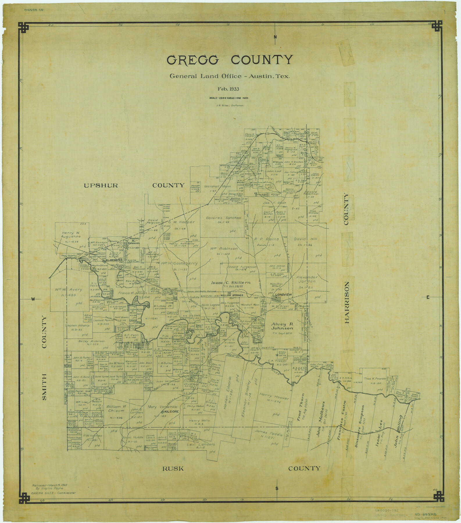
Gregg County
-
Map/Doc
66842
-
Collection
General Map Collection
-
Object Dates
1933 (Creation Date)
-
People and Organizations
Texas General Land Office (Publisher)
Bascom Giles (GLO Commissioner)
J. Bascom Giles (Draftsman)
J. Bascom Giles (Compiler)
-
Counties
Gregg
-
Subjects
County
-
Height x Width
34.4 x 30.3 inches
87.4 x 77.0 cm
-
Comments
Retraced March 9, 1943 by Virginia Payne.
Part of: General Map Collection
Webb County Sketch File 5a

Print $8.00
- Digital $50.00
Webb County Sketch File 5a
1877
Size 12.9 x 8.2 inches
Map/Doc 39729
Callahan County

Print $20.00
- Digital $50.00
Callahan County
1918
Size 45.5 x 40.3 inches
Map/Doc 4787
Northeast Part of Webb County

Print $40.00
- Digital $50.00
Northeast Part of Webb County
1986
Size 37.7 x 50.0 inches
Map/Doc 95668
Rusk County Working Sketch 25

Print $20.00
- Digital $50.00
Rusk County Working Sketch 25
1941
Size 39.8 x 25.1 inches
Map/Doc 63661
Morris County Rolled Sketch 2A

Print $20.00
- Digital $50.00
Morris County Rolled Sketch 2A
Size 35.2 x 27.7 inches
Map/Doc 10270
Hutchinson County Sketch File 52

Print $14.00
- Digital $50.00
Hutchinson County Sketch File 52
1992
Size 14.2 x 8.8 inches
Map/Doc 27449
Flight Mission No. DAH-17M, Frame 62, Orange County

Print $20.00
- Digital $50.00
Flight Mission No. DAH-17M, Frame 62, Orange County
1953
Size 18.5 x 22.6 inches
Map/Doc 86896
Goliad County Sketch File 35

Print $20.00
- Digital $50.00
Goliad County Sketch File 35
1924
Size 22.8 x 27.6 inches
Map/Doc 11570
Reagan County Sketch File 28

Print $20.00
- Digital $50.00
Reagan County Sketch File 28
1951
Size 29.6 x 21.7 inches
Map/Doc 12224
Navarro County Sketch File 6

Print $6.00
- Digital $50.00
Navarro County Sketch File 6
1849
Size 6.2 x 8.4 inches
Map/Doc 32310
Flight Mission No. BRA-8M, Frame 26, Jefferson County

Print $20.00
- Digital $50.00
Flight Mission No. BRA-8M, Frame 26, Jefferson County
1953
Size 18.6 x 22.3 inches
Map/Doc 85581
Hays County Working Sketch 9

Print $40.00
- Digital $50.00
Hays County Working Sketch 9
1949
Size 22.8 x 50.5 inches
Map/Doc 66083
You may also like
Crockett County Sketch File 35c

Print $8.00
- Digital $50.00
Crockett County Sketch File 35c
Size 14.3 x 8.8 inches
Map/Doc 19746
Polk County Sketch File 34

Print $20.00
- Digital $50.00
Polk County Sketch File 34
Size 16.9 x 18.2 inches
Map/Doc 12194
Borden County Working Sketch 15

Print $20.00
- Digital $50.00
Borden County Working Sketch 15
1984
Size 25.5 x 18.9 inches
Map/Doc 67475
La Salle County Rolled Sketch 23

Print $40.00
- Digital $50.00
La Salle County Rolled Sketch 23
1956
Size 34.5 x 48.0 inches
Map/Doc 9559
Midland County Boundary File 4

Print $18.00
- Digital $50.00
Midland County Boundary File 4
Size 8.8 x 8.0 inches
Map/Doc 57176
Milam County Rolled Sketch 2

Print $20.00
- Digital $50.00
Milam County Rolled Sketch 2
1954
Size 21.9 x 24.8 inches
Map/Doc 6774
Nacogdoches County Working Sketch 4

Print $20.00
- Digital $50.00
Nacogdoches County Working Sketch 4
1946
Size 22.2 x 23.2 inches
Map/Doc 71220
Map of Nacogdoches County, Texas

Print $20.00
- Digital $50.00
Map of Nacogdoches County, Texas
1881
Size 24.6 x 21.1 inches
Map/Doc 585
Harris County Working Sketch 92

Print $40.00
- Digital $50.00
Harris County Working Sketch 92
1974
Size 33.8 x 55.5 inches
Map/Doc 69648
[Cotton Belt, St. Louis Southwestern Railway of Texas, Alignment through Smith County]
![64375, [Cotton Belt, St. Louis Southwestern Railway of Texas, Alignment through Smith County], General Map Collection](https://historictexasmaps.com/wmedia_w700/maps/64375.tif.jpg)
Print $20.00
- Digital $50.00
[Cotton Belt, St. Louis Southwestern Railway of Texas, Alignment through Smith County]
1903
Size 21.3 x 28.5 inches
Map/Doc 64375
Brazos River, Brazos River Sheet 1

Print $20.00
- Digital $50.00
Brazos River, Brazos River Sheet 1
1926
Size 20.7 x 25.3 inches
Map/Doc 69665
Lynn County Sketch File 11

Print $4.00
- Digital $50.00
Lynn County Sketch File 11
1906
Size 14.2 x 8.6 inches
Map/Doc 30478