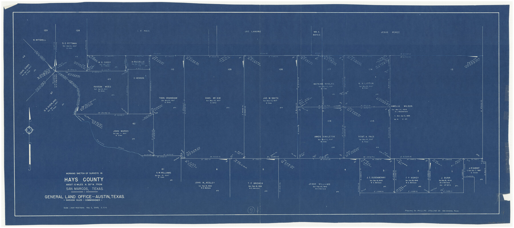
Hays County Working Sketch 9
-
Map/Doc
66083
-
Collection
General Map Collection
-
Object Dates
5/5/1949 (Creation Date)
-
People and Organizations
Otto G. Kurio (Draftsman)
-
Counties
Hays
-
Subjects
Surveying Working Sketch
-
Height x Width
22.8 x 50.5 inches
57.9 x 128.3 cm
-
Scale
1" = 400 varas
Part of: General Map Collection
Flight Mission No. DQN-1K, Frame 47, Calhoun County

Print $20.00
- Digital $50.00
Flight Mission No. DQN-1K, Frame 47, Calhoun County
1953
Size 18.4 x 22.6 inches
Map/Doc 84147
Map of the Surveyed Part of Young District

Print $40.00
- Digital $50.00
Map of the Surveyed Part of Young District
1860
Size 56.3 x 32.6 inches
Map/Doc 87373
La Salle County Sketch File 22

Print $4.00
- Digital $50.00
La Salle County Sketch File 22
1875
Size 12.8 x 8.2 inches
Map/Doc 29528
Map of Eastham State Farm, Houston County, Texas

Print $20.00
- Digital $50.00
Map of Eastham State Farm, Houston County, Texas
Size 35.7 x 32.5 inches
Map/Doc 62987
Cherokee County Working Sketch 9

Print $20.00
- Digital $50.00
Cherokee County Working Sketch 9
1957
Size 46.9 x 34.0 inches
Map/Doc 67964
Jack County Working Sketch 21

Print $20.00
- Digital $50.00
Jack County Working Sketch 21
1993
Size 28.3 x 40.0 inches
Map/Doc 66447
Flight Mission No. DIX-10P, Frame 181, Aransas County

Print $20.00
- Digital $50.00
Flight Mission No. DIX-10P, Frame 181, Aransas County
1956
Size 18.5 x 22.2 inches
Map/Doc 83971

Winkler County Working Sketch Graphic Index

Print $20.00
- Digital $50.00
Winkler County Working Sketch Graphic Index
1932
Size 36.4 x 36.4 inches
Map/Doc 76744
Cass County Working Sketch 37

Print $20.00
- Digital $50.00
Cass County Working Sketch 37
1982
Size 26.8 x 31.8 inches
Map/Doc 67940
Sutton County Sketch File 18

Print $94.00
- Digital $50.00
Sutton County Sketch File 18
1893
Size 12.9 x 8.3 inches
Map/Doc 37410
Morris County Sketch File 1

Print $4.00
- Digital $50.00
Morris County Sketch File 1
Size 12.4 x 6.5 inches
Map/Doc 31963
You may also like
Flight Mission No. DQO-8K, Frame 15, Galveston County

Print $20.00
- Digital $50.00
Flight Mission No. DQO-8K, Frame 15, Galveston County
1952
Size 18.7 x 22.4 inches
Map/Doc 85138
Crosby County Sketch File 2

Print $22.00
- Digital $50.00
Crosby County Sketch File 2
Size 8.5 x 9.9 inches
Map/Doc 19991
General Highway Map, Lynn County, Texas

Print $20.00
General Highway Map, Lynn County, Texas
1940
Size 18.2 x 24.9 inches
Map/Doc 79182
Flight Mission No. BRE-1P, Frame 34, Nueces County

Print $20.00
- Digital $50.00
Flight Mission No. BRE-1P, Frame 34, Nueces County
1956
Size 18.4 x 22.2 inches
Map/Doc 86630
Brown County Working Sketch 2

Print $20.00
- Digital $50.00
Brown County Working Sketch 2
1919
Size 17.0 x 17.5 inches
Map/Doc 67767
Webb County Working Sketch Graphic Index - northwest part

Print $40.00
- Digital $50.00
Webb County Working Sketch Graphic Index - northwest part
1984
Size 42.1 x 51.6 inches
Map/Doc 76736
Outer Continental Shelf Leasing Maps (Louisiana Offshore Operations)

Print $20.00
- Digital $50.00
Outer Continental Shelf Leasing Maps (Louisiana Offshore Operations)
1955
Size 11.1 x 13.3 inches
Map/Doc 76090
Texas-Oklahoma Boundary Line: brief summary of the lands surveyed and the lands not surveyed in the dispute between Oklahoma vs. Texas

Print $356.00
- Digital $50.00
Texas-Oklahoma Boundary Line: brief summary of the lands surveyed and the lands not surveyed in the dispute between Oklahoma vs. Texas
1923
Size 6.0 x 9.2 inches
Map/Doc 3061
Atascosa County Sketch File 27b

Print $10.00
- Digital $50.00
Atascosa County Sketch File 27b
1875
Size 12.6 x 8.2 inches
Map/Doc 13801
Flight Mission No. BRA-3M, Frame 120, Jefferson County

Print $20.00
- Digital $50.00
Flight Mission No. BRA-3M, Frame 120, Jefferson County
1953
Size 18.6 x 22.3 inches
Map/Doc 85394
Hill County Sketch File 18

Print $26.00
- Digital $50.00
Hill County Sketch File 18
1852
Size 8.6 x 4.9 inches
Map/Doc 26486
Supplemental Plat, T. 4S., R. 14W., Indian Meridian, Oklahoma

Print $4.00
- Digital $50.00
Supplemental Plat, T. 4S., R. 14W., Indian Meridian, Oklahoma
1926
Size 18.1 x 23.6 inches
Map/Doc 75149