Crockett County Sketch File 35c
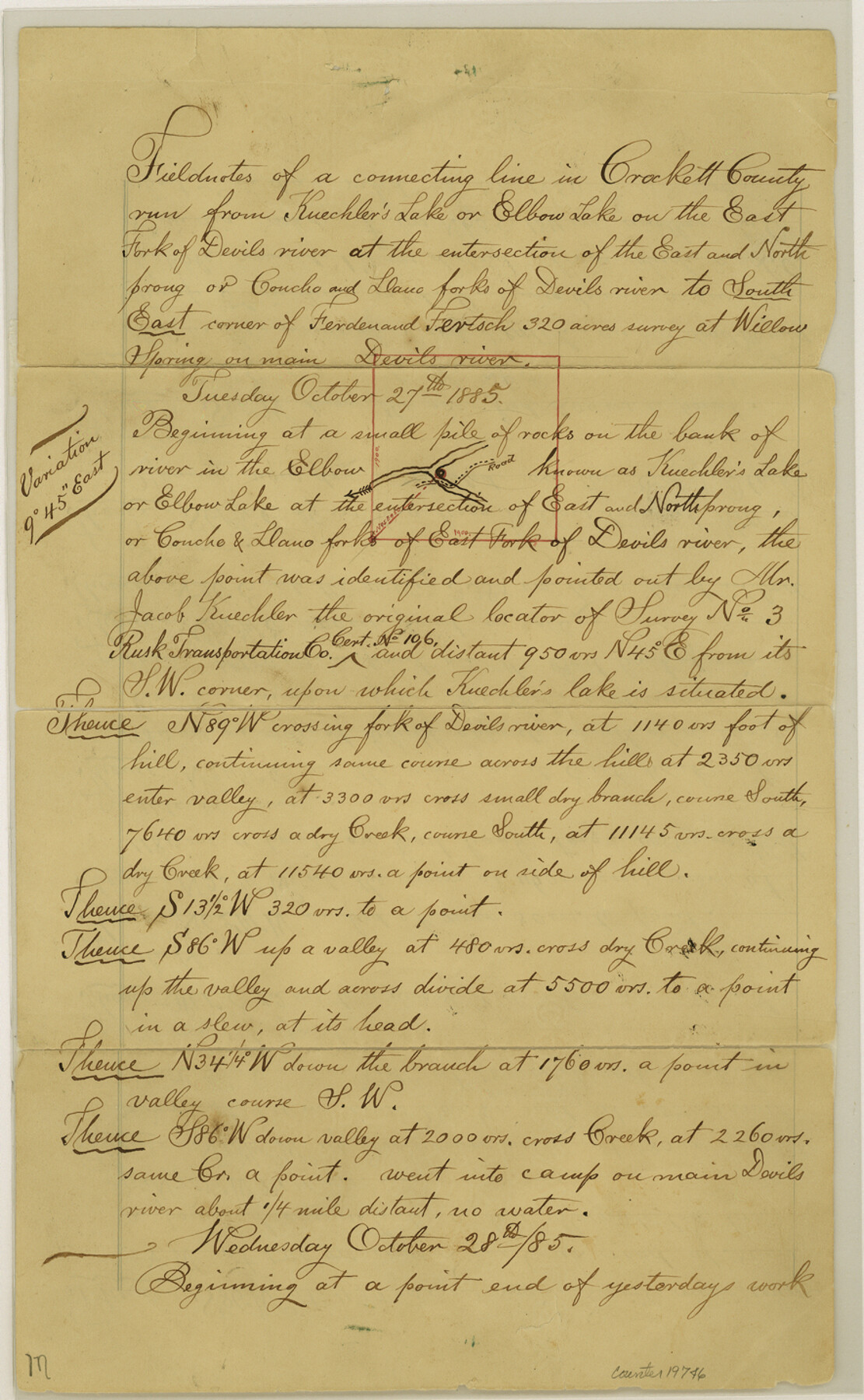
[Connecting line between Kuechler's Lake or Elbow Lake to the southeast corner of F. Fertsch at Willow Spring on Main Devil's River]
-
Map/Doc
19746
-
Collection
General Map Collection
-
Object Dates
1887/1/22 (File Date)
-
People and Organizations
Jacob Kuechler (Surveyor/Engineer)
S.H. Locke (Chainman)
E. McMillan (Chainman)
E. von Rosenberg (Chainman)
-
Counties
Crockett
-
Subjects
Surveying Sketch File
-
Height x Width
14.3 x 8.8 inches
36.3 x 22.4 cm
-
Medium
paper, manuscript
-
Features
Kuechler's Lake
Elbow Lake
Concho Fork on Devil's River
Llano Fork on Devil's River
Willow Spring
Devil's River
Dove Creek
East Fork of Devil's River
Part of: General Map Collection
Hutchinson County Boundary File 1a

Print $10.00
- Digital $50.00
Hutchinson County Boundary File 1a
Size 7.3 x 8.7 inches
Map/Doc 55297
Arlington Street Map & Guide

Digital $50.00
Arlington Street Map & Guide
Size 35.5 x 23.2 inches
Map/Doc 94436
Flight Mission No. DCL-7C, Frame 116, Kenedy County

Print $20.00
- Digital $50.00
Flight Mission No. DCL-7C, Frame 116, Kenedy County
1943
Size 18.6 x 22.4 inches
Map/Doc 86081
Milam County Working Sketch 9

Print $20.00
- Digital $50.00
Milam County Working Sketch 9
1976
Size 27.2 x 22.7 inches
Map/Doc 71024
Harris County Historic Topographic 16

Print $20.00
- Digital $50.00
Harris County Historic Topographic 16
1916
Size 29.3 x 22.9 inches
Map/Doc 65826
Baylor County Rolled Sketch WAJ

Print $20.00
- Digital $50.00
Baylor County Rolled Sketch WAJ
Size 22.0 x 17.0 inches
Map/Doc 5132
Jones County Working Sketch 10

Print $20.00
- Digital $50.00
Jones County Working Sketch 10
1982
Size 19.3 x 34.3 inches
Map/Doc 66648
[Surveys in Austin's Colony along the east bank of Mill Creek]
![216, [Surveys in Austin's Colony along the east bank of Mill Creek], General Map Collection](https://historictexasmaps.com/wmedia_w700/maps/216.tif.jpg)
Print $3.00
- Digital $50.00
[Surveys in Austin's Colony along the east bank of Mill Creek]
1827
Size 14.4 x 11.1 inches
Map/Doc 216
Flight Mission No. DQN-2K, Frame 34, Calhoun County

Print $20.00
- Digital $50.00
Flight Mission No. DQN-2K, Frame 34, Calhoun County
1953
Size 18.5 x 22.2 inches
Map/Doc 84241
Tom Green County Working Sketch 10

Print $20.00
- Digital $50.00
Tom Green County Working Sketch 10
1959
Size 22.0 x 32.7 inches
Map/Doc 69379
Nueces County Rolled Sketch 65

Print $20.00
- Digital $50.00
Nueces County Rolled Sketch 65
1979
Size 19.5 x 26.2 inches
Map/Doc 6917

You may also like
Flight Mission No. DAG-24K, Frame 157, Matagorda County

Print $20.00
- Digital $50.00
Flight Mission No. DAG-24K, Frame 157, Matagorda County
1953
Size 18.6 x 22.5 inches
Map/Doc 86571
Throckmorton County Rolled Sketch 3B

Print $20.00
- Digital $50.00
Throckmorton County Rolled Sketch 3B
Size 31.3 x 37.9 inches
Map/Doc 7988
Gulf Intracoastal Waterway, Tex. - Aransas Bay to Corpus Christi Bay - Modified Route of Main Channel/Dredging

Print $20.00
- Digital $50.00
Gulf Intracoastal Waterway, Tex. - Aransas Bay to Corpus Christi Bay - Modified Route of Main Channel/Dredging
1958
Size 31.3 x 42.6 inches
Map/Doc 61894
Galveston County NRC Article 33.136 Sketch 81

Print $202.00
- Digital $50.00
Galveston County NRC Article 33.136 Sketch 81
2015
Size 34.0 x 22.0 inches
Map/Doc 94976
The Republic County of Harris. December 29, 1845

Print $20.00
The Republic County of Harris. December 29, 1845
2020
Size 17.7 x 21.7 inches
Map/Doc 96168
Padre Island National Seashore

Print $4.00
- Digital $50.00
Padre Island National Seashore
Size 16.1 x 22.3 inches
Map/Doc 60538
General Highway Map, Reeves County, Texas

Print $20.00
General Highway Map, Reeves County, Texas
1940
Size 24.8 x 18.2 inches
Map/Doc 79227
Palo Pinto County Rolled Sketch 2

Print $20.00
- Digital $50.00
Palo Pinto County Rolled Sketch 2
1917
Size 37.5 x 43.8 inches
Map/Doc 9669
Colton's new map of the state of Texas, the Indian Territory and adjoining portions of New Mexico, Louisiana, and Arkansas

Print $20.00
Colton's new map of the state of Texas, the Indian Territory and adjoining portions of New Mexico, Louisiana, and Arkansas
1872
Size 31.1 x 36.6 inches
Map/Doc 93579
Frio County Rolled Sketch 17

Print $20.00
- Digital $50.00
Frio County Rolled Sketch 17
1953
Size 32.4 x 44.5 inches
Map/Doc 8907
Goliad County Sketch File 28

Print $20.00
- Digital $50.00
Goliad County Sketch File 28
Size 18.9 x 15.5 inches
Map/Doc 11569
Dickens County Sketch File 19

Print $4.00
- Digital $50.00
Dickens County Sketch File 19
1910
Size 8.4 x 7.5 inches
Map/Doc 20982