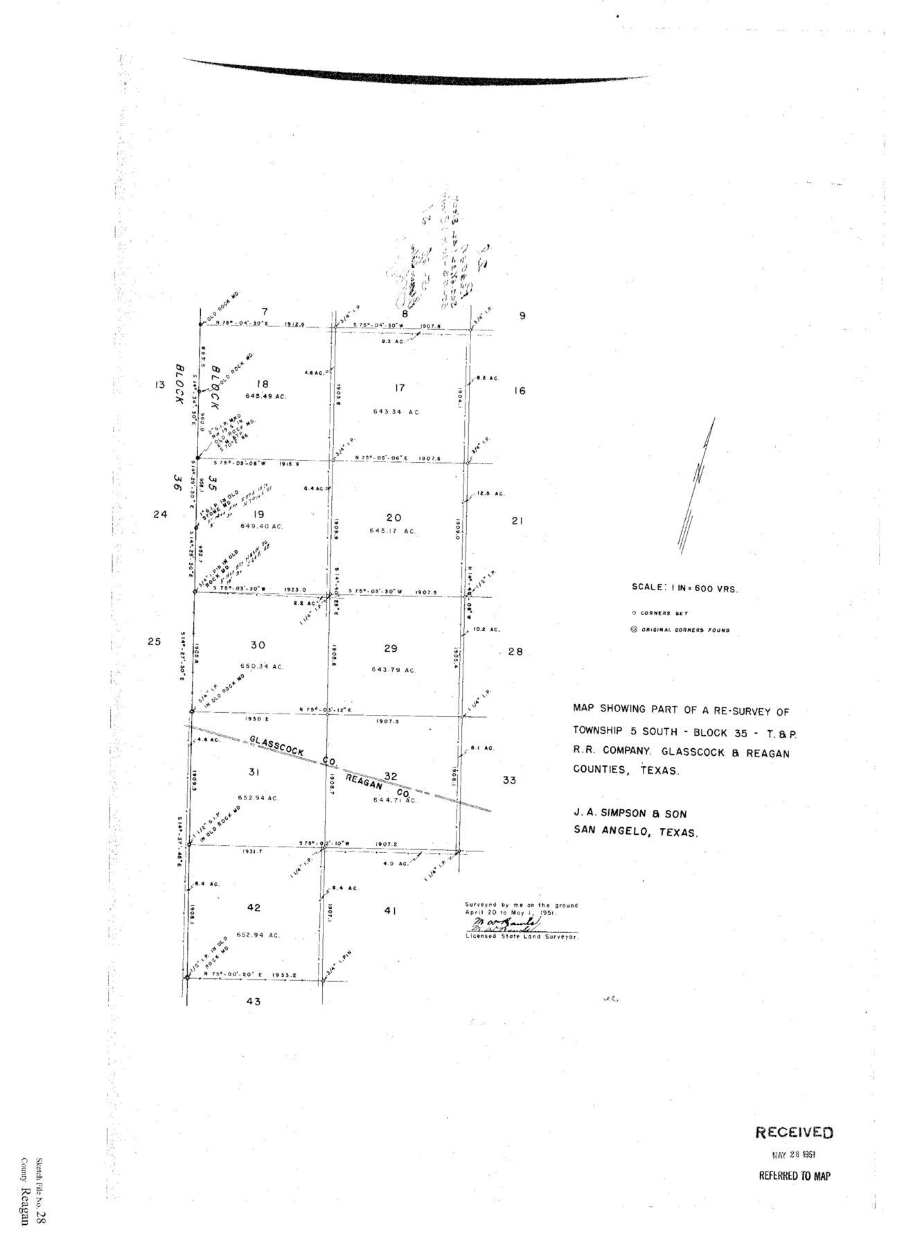
Reagan County Sketch File 28
Map Showing Part of a Resurvey of Tsp. 5 South, Block 35, T&PRRCo., Glasscock & Reagan Counties, Texas
-
Map/Doc
12224
-
Collection
General Map Collection
-
Object Dates
1951/4/20 (Creation Date)
1951/5/28 (File Date)
1951/4/20 (Survey Date)
1951/5/1 (Survey Date)
-
People and Organizations
M.D. Rawls (Surveyor/Engineer)
-
Counties
Reagan Glasscock
-
Subjects
Surveying Sketch File
-
Height x Width
29.6 x 21.7 inches
75.2 x 55.1 cm
-
Medium
paper, print
-
Scale
1:600
Part of: General Map Collection
Terrell County Working Sketch 25

Print $40.00
- Digital $50.00
Terrell County Working Sketch 25
1942
Size 41.9 x 49.1 inches
Map/Doc 62175
[Sketch for Mineral Application 19560 - 19588 - San Bernard River]
![65661, [Sketch for Mineral Application 19560 - 19588 - San Bernard River], General Map Collection](https://historictexasmaps.com/wmedia_w700/maps/65661.tif.jpg)
Print $40.00
- Digital $50.00
[Sketch for Mineral Application 19560 - 19588 - San Bernard River]
Size 32.3 x 98.5 inches
Map/Doc 65661
Crane County Working Sketch 17

Print $20.00
- Digital $50.00
Crane County Working Sketch 17
1957
Size 10.7 x 37.0 inches
Map/Doc 63911
G.C. & S.F. Ry. Main Line, Texas, Right of Way Map, Keeler to Haslet

Print $40.00
- Digital $50.00
G.C. & S.F. Ry. Main Line, Texas, Right of Way Map, Keeler to Haslet
1916
Size 25.3 x 103.5 inches
Map/Doc 64546
Map of the Town of Giddings

Print $20.00
- Digital $50.00
Map of the Town of Giddings
1871
Size 23.9 x 29.8 inches
Map/Doc 89270
Map of the country upon the Brazos and Big Witchita Rivers

Print $20.00
- Digital $50.00
Map of the country upon the Brazos and Big Witchita Rivers
1854
Size 30.3 x 34.9 inches
Map/Doc 4663
Montgomery County Sketch File 20

Print $38.00
- Digital $50.00
Montgomery County Sketch File 20
1932
Size 14.3 x 8.8 inches
Map/Doc 31847
Houston County Working Sketch 4

Print $20.00
- Digital $50.00
Houston County Working Sketch 4
1911
Size 15.5 x 21.8 inches
Map/Doc 66234
Grimes County

Print $40.00
- Digital $50.00
Grimes County
1922
Size 55.7 x 28.2 inches
Map/Doc 77296
Pecos County Working Sketch 26

Print $20.00
- Digital $50.00
Pecos County Working Sketch 26
1929
Size 27.6 x 28.6 inches
Map/Doc 71497
Victoria County Rolled Sketch 5

Print $20.00
- Digital $50.00
Victoria County Rolled Sketch 5
1961
Size 27.8 x 43.8 inches
Map/Doc 8151
Flight Mission No. BRA-17M, Frame 6, Jefferson County

Print $20.00
- Digital $50.00
Flight Mission No. BRA-17M, Frame 6, Jefferson County
1953
Size 18.5 x 22.2 inches
Map/Doc 85787
You may also like
Right-of-way & Track Map Dawson Railway Operated by the El Paso & Southwestern Company Station 810+61.6 to Station 1021+79.7

Print $40.00
- Digital $50.00
Right-of-way & Track Map Dawson Railway Operated by the El Paso & Southwestern Company Station 810+61.6 to Station 1021+79.7
1910
Size 56.6 x 24.7 inches
Map/Doc 89662
University Lands Blocks 1 to 11 Andrews-Martin-Gaines-Dawson-Winkler Counties

Print $6.00
- Digital $50.00
University Lands Blocks 1 to 11 Andrews-Martin-Gaines-Dawson-Winkler Counties
Size 30.9 x 35.3 inches
Map/Doc 62930
McCulloch County Rolled Sketch 11

Print $20.00
- Digital $50.00
McCulloch County Rolled Sketch 11
1992
Size 46.3 x 40.3 inches
Map/Doc 9499
Upton County Working Sketch 29

Print $40.00
- Digital $50.00
Upton County Working Sketch 29
1956
Size 50.6 x 36.0 inches
Map/Doc 69525
[Surveys in Cherokee County]
![251, [Surveys in Cherokee County], General Map Collection](https://historictexasmaps.com/wmedia_w700/maps/251.tif.jpg)
Print $2.00
- Digital $50.00
[Surveys in Cherokee County]
Size 8.0 x 5.6 inches
Map/Doc 251
Jefferson County Sketch File 8a

Print $42.00
- Digital $50.00
Jefferson County Sketch File 8a
Size 8.6 x 7.8 inches
Map/Doc 28120
Galveston County Rolled Sketch 18

Print $20.00
- Digital $50.00
Galveston County Rolled Sketch 18
1958
Size 24.1 x 32.0 inches
Map/Doc 5956
Hays County Sketch File 28

Print $20.00
- Digital $50.00
Hays County Sketch File 28
1912
Size 26.0 x 20.0 inches
Map/Doc 11750
Val Verde County Sketch File N

Print $14.00
- Digital $50.00
Val Verde County Sketch File N
1920
Size 10.9 x 8.8 inches
Map/Doc 39284
Map of the Rio Grande & Eagle Pass Ry. from Sections 21-25 9/10 Inclusive, Webb County

Print $40.00
- Digital $50.00
Map of the Rio Grande & Eagle Pass Ry. from Sections 21-25 9/10 Inclusive, Webb County
1909
Size 25.8 x 55.4 inches
Map/Doc 64658
Brown County Sketch File 24

Print $6.00
- Digital $50.00
Brown County Sketch File 24
1889
Size 11.7 x 15.9 inches
Map/Doc 11022
Presidio County Rolled Sketch 7

Print $40.00
- Digital $50.00
Presidio County Rolled Sketch 7
1875
Size 37.5 x 53.8 inches
Map/Doc 9762