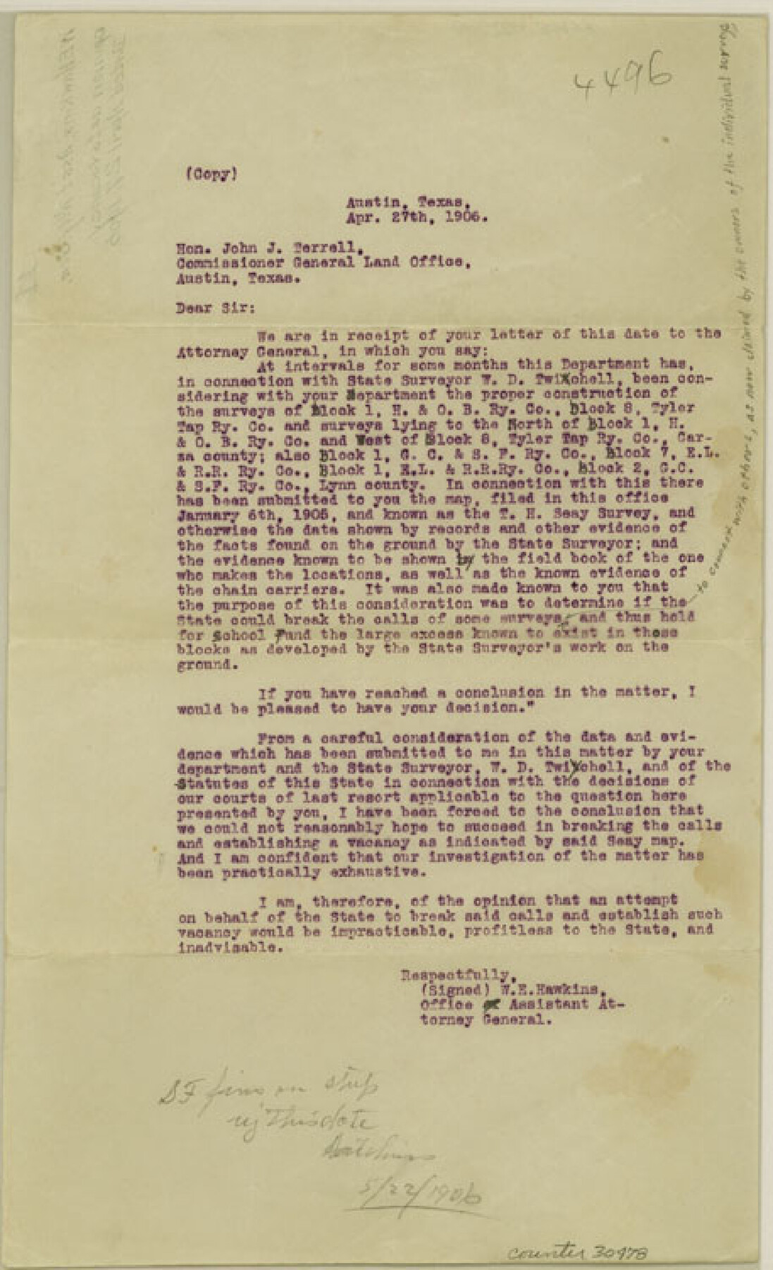
Lynn County Sketch File 11
[Assistant Attorney General opinion as to vacancy]
-
Map/Doc
30478
-
Collection
General Map Collection
-
Object Dates
4/27/1906 (Creation Date)
4/27/1906 (Correspondence Date)
1/6/1906 (File Date)
-
People and Organizations
W.E. Hawkins (Attorney)
W.D. Twichell (Surveyor/Engineer)
-
Counties
Lynn
-
Subjects
Surveying Sketch File
-
Height x Width
14.2 x 8.6 inches
36.1 x 21.8 cm
-
Medium
paper, print
Part of: General Map Collection
Shackelford County Working Sketch 13

Print $20.00
- Digital $50.00
Shackelford County Working Sketch 13
1999
Size 18.6 x 16.2 inches
Map/Doc 63853
Lampasas County Rolled Sketch 3

Print $20.00
- Digital $50.00
Lampasas County Rolled Sketch 3
Size 43.8 x 33.9 inches
Map/Doc 9554
Chambers County NRC Article 33.136 Sketch 16

Print $184.00
Chambers County NRC Article 33.136 Sketch 16
2025
Map/Doc 97514
Cooke County Sketch File 9

Print $6.00
- Digital $50.00
Cooke County Sketch File 9
Size 8.2 x 10.5 inches
Map/Doc 19237
Chocolate Bay, West Portion of West Bay and Vicinity, Brazoria and Galveston Counties, showing Subdivision for Mineral Development

Print $40.00
- Digital $50.00
Chocolate Bay, West Portion of West Bay and Vicinity, Brazoria and Galveston Counties, showing Subdivision for Mineral Development
1948
Size 40.7 x 53.9 inches
Map/Doc 1907
Fisher County Rolled Sketch 6

Print $20.00
- Digital $50.00
Fisher County Rolled Sketch 6
1971
Size 26.9 x 26.7 inches
Map/Doc 5877
Jefferson County Sketch File 15a

Print $8.00
- Digital $50.00
Jefferson County Sketch File 15a
1872
Size 15.6 x 6.7 inches
Map/Doc 28156
[Surveys in the Bexar District]
![24, [Surveys in the Bexar District], General Map Collection](https://historictexasmaps.com/wmedia_w700/maps/24-1.tif.jpg)
Print $20.00
- Digital $50.00
[Surveys in the Bexar District]
1841
Size 23.0 x 16.5 inches
Map/Doc 24
Howard County Sketch File 6

Print $44.00
- Digital $50.00
Howard County Sketch File 6
1929
Size 18.6 x 14.4 inches
Map/Doc 26861
Nueces County Rolled Sketch 77

Print $55.00
Nueces County Rolled Sketch 77
1982
Size 24.6 x 36.3 inches
Map/Doc 6938
Donley County Boundary File 2

Print $10.00
- Digital $50.00
Donley County Boundary File 2
Size 8.7 x 11.3 inches
Map/Doc 52619
Angelina County Sketch File 7

Print $40.00
- Digital $50.00
Angelina County Sketch File 7
1858
Size 15.5 x 35.8 inches
Map/Doc 10812
You may also like
[Surveys along Green's Creek and the North Bosque River]
![69756, [Surveys along Green's Creek and the North Bosque River], General Map Collection](https://historictexasmaps.com/wmedia_w700/maps/69756.tif.jpg)
Print $2.00
- Digital $50.00
[Surveys along Green's Creek and the North Bosque River]
1846
Size 11.9 x 8.1 inches
Map/Doc 69756
Aransas County Rolled Sketch 20

Print $20.00
- Digital $50.00
Aransas County Rolled Sketch 20
Size 43.2 x 47.3 inches
Map/Doc 8414
[Sections in the vicinity of John P. Rohus and Mary Fury surveys]
![92987, [Sections in the vicinity of John P. Rohus and Mary Fury surveys], Twichell Survey Records](https://historictexasmaps.com/wmedia_w700/maps/92987-1.tif.jpg)
Print $20.00
- Digital $50.00
[Sections in the vicinity of John P. Rohus and Mary Fury surveys]
Size 12.2 x 13.1 inches
Map/Doc 92987
Midland County

Print $20.00
- Digital $50.00
Midland County
1930
Size 39.8 x 33.1 inches
Map/Doc 77372
Shelby County Working Sketch 20

Print $20.00
- Digital $50.00
Shelby County Working Sketch 20
1970
Size 28.0 x 22.8 inches
Map/Doc 63873
[Sketch for Mineral Application 31137 - Colorado River, W. A. Wagner]
![65633, [Sketch for Mineral Application 31137 - Colorado River, W. A. Wagner], General Map Collection](https://historictexasmaps.com/wmedia_w700/maps/65633.tif.jpg)
Print $40.00
- Digital $50.00
[Sketch for Mineral Application 31137 - Colorado River, W. A. Wagner]
1928
Size 39.6 x 126.4 inches
Map/Doc 65633
Val Verde County Working Sketch 114

Print $20.00
- Digital $50.00
Val Verde County Working Sketch 114
1993
Size 25.9 x 40.9 inches
Map/Doc 72249
Cooke County Working Sketch 26

Print $20.00
- Digital $50.00
Cooke County Working Sketch 26
1974
Size 33.9 x 39.2 inches
Map/Doc 68263
Right of Way & Track Map San Antonio & Aransas Pass Railway Co.

Print $40.00
- Digital $50.00
Right of Way & Track Map San Antonio & Aransas Pass Railway Co.
1919
Size 25.1 x 56.7 inches
Map/Doc 64026
Map of Ellis County

Print $20.00
- Digital $50.00
Map of Ellis County
1889
Size 38.9 x 47.7 inches
Map/Doc 4941
Starr County Rolled Sketch 15

Print $20.00
- Digital $50.00
Starr County Rolled Sketch 15
1913
Size 22.7 x 23.6 inches
Map/Doc 7800
Panola County Working Sketch 16

Print $20.00
- Digital $50.00
Panola County Working Sketch 16
1945
Map/Doc 71425