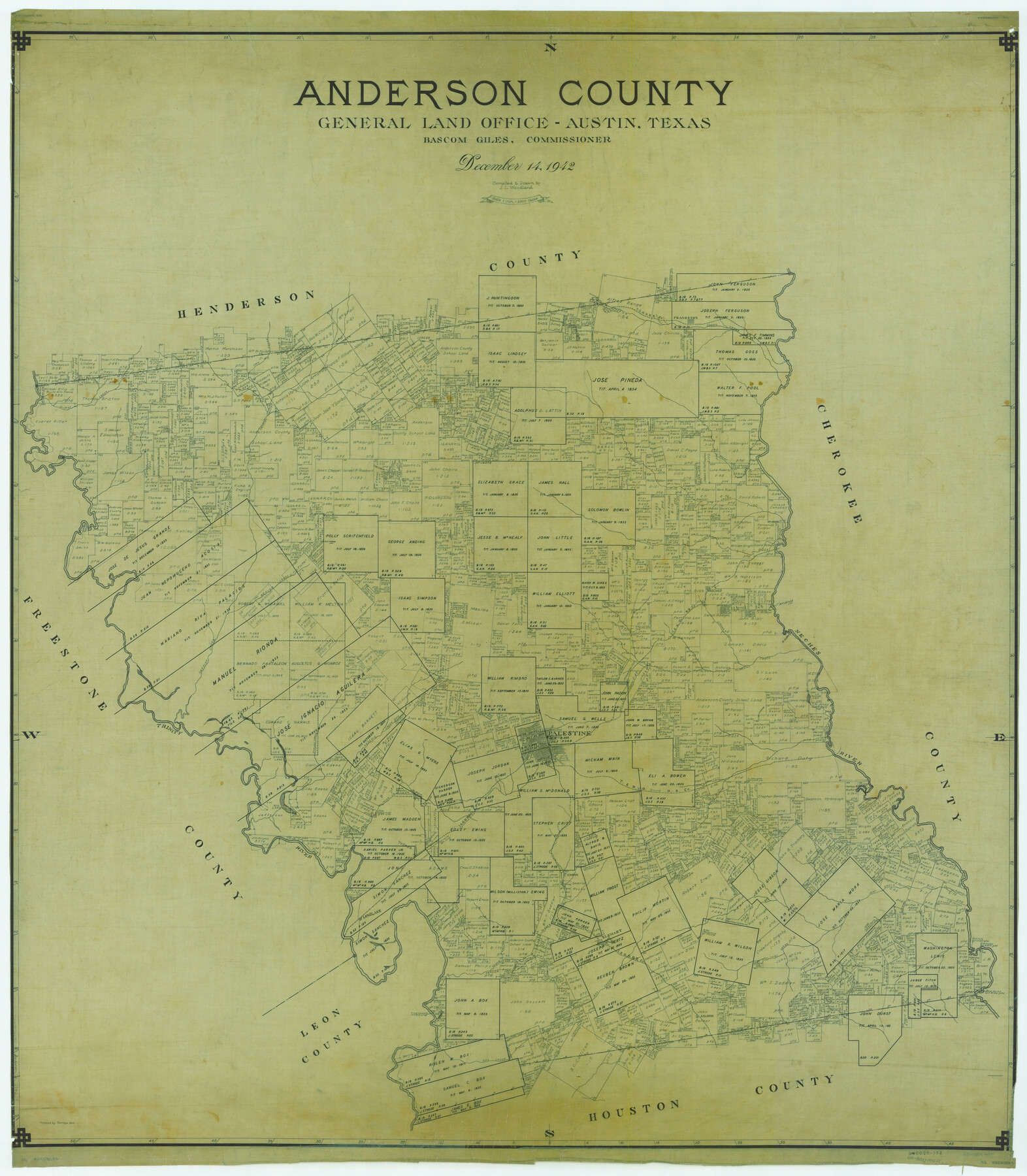
Anderson County
-
Map/Doc
66701
-
Collection
General Map Collection
-
Object Dates
1942/12/14 (Creation Date)
-
People and Organizations
Texas General Land Office (Publisher)
J.L. Woodland (Compiler)
J.L. Woodland (Draftsman)
-
Counties
Anderson
-
Subjects
County
-
Height x Width
54.2 x 47.3 inches
137.7 x 120.1 cm
-
Comments
Traced by Tommye Buie.
Part of: General Map Collection
Wood County Working Sketch 9

Print $20.00
- Digital $50.00
Wood County Working Sketch 9
1943
Size 36.0 x 28.5 inches
Map/Doc 62009
Austin County Rolled Sketch 7

Print $47.00
- Digital $50.00
Austin County Rolled Sketch 7
1974
Size 10.4 x 15.3 inches
Map/Doc 42340
Haskell County Rolled Sketch 10

Print $20.00
- Digital $50.00
Haskell County Rolled Sketch 10
1981
Size 33.2 x 14.3 inches
Map/Doc 6169
Nueces County Aerial Photograph Index Sheet 6

Print $20.00
- Digital $50.00
Nueces County Aerial Photograph Index Sheet 6
1956
Size 23.4 x 19.2 inches
Map/Doc 83739
Reeves County Rolled Sketch 35

Print $20.00
- Digital $50.00
Reeves County Rolled Sketch 35
2013
Size 25.3 x 36.8 inches
Map/Doc 93706
Flight Mission No. DCL-3C, Frame 155, Kenedy County

Print $20.00
- Digital $50.00
Flight Mission No. DCL-3C, Frame 155, Kenedy County
1943
Size 18.6 x 22.4 inches
Map/Doc 85803
Dimmit County Rolled Sketch 12

Print $20.00
- Digital $50.00
Dimmit County Rolled Sketch 12
1942
Size 19.8 x 21.5 inches
Map/Doc 5721
Recharge zone of the Edwards Aquifer hydrologically associated with Barton Springs in the Austin Area, Texas

Print $20.00
- Digital $50.00
Recharge zone of the Edwards Aquifer hydrologically associated with Barton Springs in the Austin Area, Texas
1986
Size 41.5 x 29.3 inches
Map/Doc 60400
Galveston County NRC Article 33.136 Location Key Sheet

Print $20.00
- Digital $50.00
Galveston County NRC Article 33.136 Location Key Sheet
1994
Size 27.0 x 22.0 inches
Map/Doc 77015
Yoakum County Rolled Sketch 3(2)

Print $40.00
- Digital $50.00
Yoakum County Rolled Sketch 3(2)
1959
Size 12.7 x 128.8 inches
Map/Doc 10163
United States - Gulf Coast - Galveston to Rio Grande

Print $20.00
- Digital $50.00
United States - Gulf Coast - Galveston to Rio Grande
Size 27.9 x 18.3 inches
Map/Doc 72739
Hudspeth County Working Sketch 32

Print $20.00
- Digital $50.00
Hudspeth County Working Sketch 32
1972
Size 21.6 x 31.7 inches
Map/Doc 66316
You may also like
[Public School Land Leagues]
![90445, [Public School Land Leagues], Twichell Survey Records](https://historictexasmaps.com/wmedia_w700/maps/90445-1.tif.jpg)
Print $3.00
- Digital $50.00
[Public School Land Leagues]
Size 11.8 x 15.8 inches
Map/Doc 90445
Hardeman County Boundary File 3b

Print $12.00
- Digital $50.00
Hardeman County Boundary File 3b
Size 14.1 x 8.7 inches
Map/Doc 54386

Flight Mission No. DQO-3K, Frame 18, Galveston County

Print $20.00
- Digital $50.00
Flight Mission No. DQO-3K, Frame 18, Galveston County
1952
Size 18.7 x 22.4 inches
Map/Doc 85059
Carte Reduite du Globe Terrestre

Print $20.00
- Digital $50.00
Carte Reduite du Globe Terrestre
1782
Size 13.5 x 17.1 inches
Map/Doc 97117
Edwards County Sketch File 14 1/2

Print $20.00
- Digital $50.00
Edwards County Sketch File 14 1/2
1887
Size 18.3 x 15.3 inches
Map/Doc 11426
Map of Jack County, State of Texas : exhibiting the extent of public surveys land grants and all other official information compiled from official surveys of the Genral Land Office at Austin…

Print $20.00
Map of Jack County, State of Texas : exhibiting the extent of public surveys land grants and all other official information compiled from official surveys of the Genral Land Office at Austin…
1876
Size 16.5 x 15.4 inches
Map/Doc 93591
Map of survey 189, T. C. R.R. Co. in Travis County, Texas

Print $20.00
- Digital $50.00
Map of survey 189, T. C. R.R. Co. in Travis County, Texas
1915
Size 18.5 x 15.2 inches
Map/Doc 663
Nacogdoches County Sketch File 5

Print $4.00
- Digital $50.00
Nacogdoches County Sketch File 5
1859
Size 12.6 x 8.1 inches
Map/Doc 32243
The Republic County of Gonzales. January 29, 1842

Print $20.00
The Republic County of Gonzales. January 29, 1842
2020
Size 14.7 x 21.7 inches
Map/Doc 96157
Principal Highways of the Southwest with particular reference to New Mexico, Oklahoma, Texas, Arkansas and Louisiana

Print $20.00
Principal Highways of the Southwest with particular reference to New Mexico, Oklahoma, Texas, Arkansas and Louisiana
1933
Size 24.3 x 18.4 inches
Map/Doc 76302
Marion County Sketch File 3

Print $8.00
- Digital $50.00
Marion County Sketch File 3
1860
Size 14.1 x 8.8 inches
Map/Doc 30566