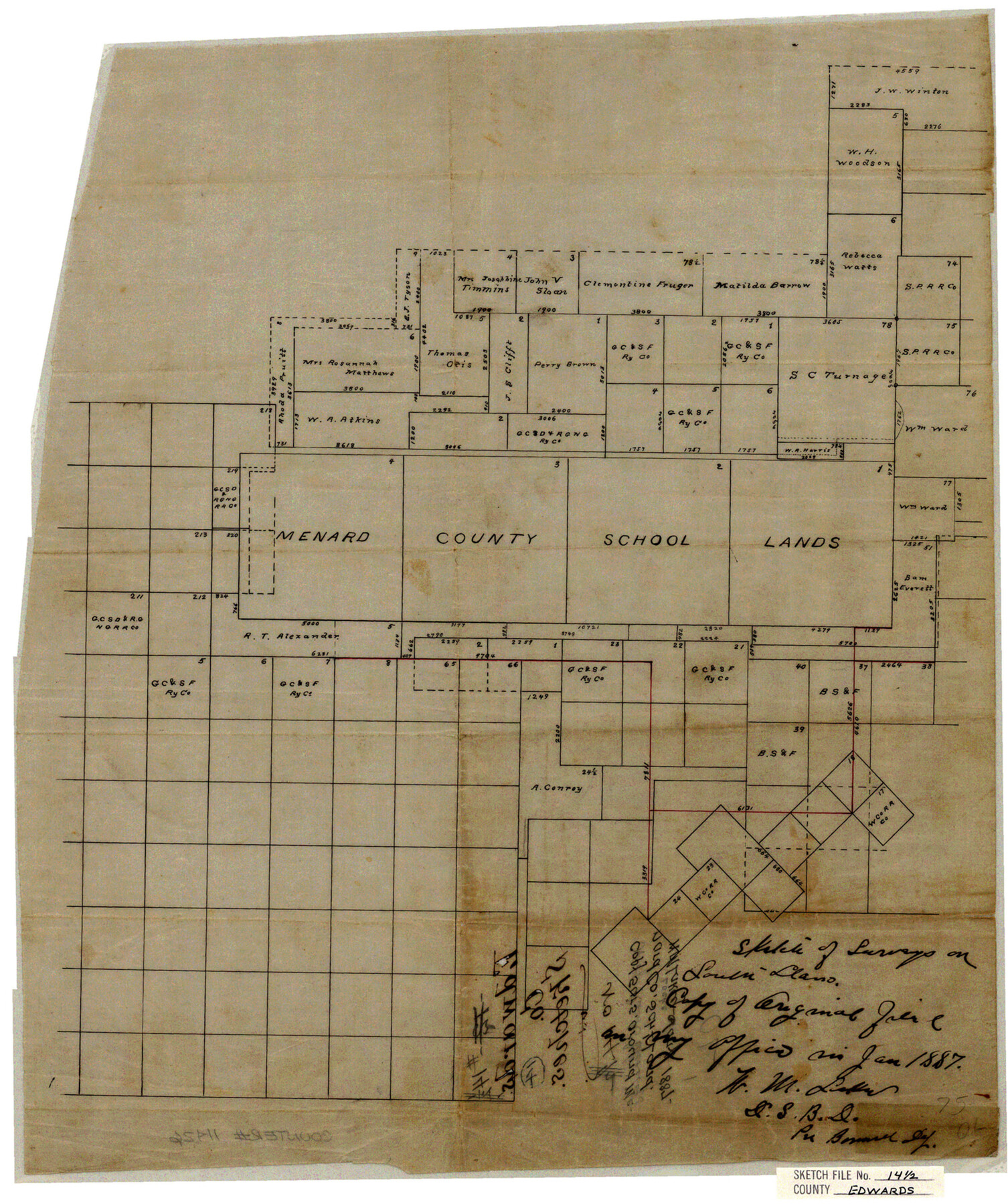
Edwards County Sketch File 14 1/2
Sketch of Surveys on South Llano
-
Map/Doc
11426
-
Collection
General Map Collection
-
Object Dates
1887 (Creation Date)
-
People and Organizations
Locke (Surveyor/Engineer)
-
Counties
Edwards Sutton
-
Subjects
Surveying Sketch File
-
Height x Width
18.3 x 15.3 inches
46.5 x 38.9 cm
-
Medium
paper, manuscript
-
Features
[South Llano River]
Part of: General Map Collection
Right of Way and Track Map International & Gt. Northern Ry. operated by the International & Gt. Northern Ry. Co., Columbia Branch, Gulf Division

Print $40.00
- Digital $50.00
Right of Way and Track Map International & Gt. Northern Ry. operated by the International & Gt. Northern Ry. Co., Columbia Branch, Gulf Division
1917
Size 25.0 x 56.8 inches
Map/Doc 64599
Parker County Rolled Sketch 6

Print $20.00
- Digital $50.00
Parker County Rolled Sketch 6
Size 28.3 x 34.1 inches
Map/Doc 7207
Travis County Sketch File 28

Print $40.00
- Digital $50.00
Travis County Sketch File 28
Size 17.5 x 12.2 inches
Map/Doc 38341
[San Antonio & Aransas Pass]
![64211, [San Antonio & Aransas Pass], General Map Collection](https://historictexasmaps.com/wmedia_w700/maps/64211.tif.jpg)
Print $2.00
- Digital $50.00
[San Antonio & Aransas Pass]
Size 11.6 x 8.2 inches
Map/Doc 64211
Oldham County Boundary File 1a

Print $62.00
- Digital $50.00
Oldham County Boundary File 1a
Size 13.0 x 8.1 inches
Map/Doc 57734
Grayson County Sketch File 20

Print $4.00
- Digital $50.00
Grayson County Sketch File 20
1861
Size 10.1 x 8.1 inches
Map/Doc 24493
Sterling County

Print $40.00
- Digital $50.00
Sterling County
1926
Size 48.5 x 34.7 inches
Map/Doc 63048
Montague County Working Sketch 36

Print $20.00
- Digital $50.00
Montague County Working Sketch 36
1980
Size 38.4 x 45.1 inches
Map/Doc 71102
Jefferson County Rolled Sketch 59

Print $40.00
- Digital $50.00
Jefferson County Rolled Sketch 59
1898
Size 30.0 x 59.4 inches
Map/Doc 9313
Dallam County

Print $20.00
- Digital $50.00
Dallam County
1901
Size 42.3 x 52.4 inches
Map/Doc 16953
Polk County Sketch File 29a

Print $4.00
- Digital $50.00
Polk County Sketch File 29a
Size 12.1 x 8.2 inches
Map/Doc 34202

You may also like
Travis County Appraisal District Plat Map 2_0404

Print $20.00
- Digital $50.00
Travis County Appraisal District Plat Map 2_0404
Size 21.5 x 26.4 inches
Map/Doc 94229
[Surveys in the Milam District Near the Upper San Gabriel River]
![247, [Surveys in the Milam District Near the Upper San Gabriel River], General Map Collection](https://historictexasmaps.com/wmedia_w700/maps/247.tif.jpg)
Print $20.00
- Digital $50.00
[Surveys in the Milam District Near the Upper San Gabriel River]
1845
Size 12.3 x 15.7 inches
Map/Doc 247
[Surveys in Southeast part of Stephens County]
![91909, [Surveys in Southeast part of Stephens County], Twichell Survey Records](https://historictexasmaps.com/wmedia_w700/maps/91909-1.tif.jpg)
Print $2.00
- Digital $50.00
[Surveys in Southeast part of Stephens County]
Size 9.1 x 7.0 inches
Map/Doc 91909
Nueces County NRC Article 33.136 Sketch 12

Print $80.00
- Digital $50.00
Nueces County NRC Article 33.136 Sketch 12
2000
Size 24.9 x 36.7 inches
Map/Doc 83065
Hood County Working Sketch 4

Print $20.00
- Digital $50.00
Hood County Working Sketch 4
1967
Size 31.6 x 36.6 inches
Map/Doc 66198
Jim Hogg County Sketch File 3

Print $6.00
- Digital $50.00
Jim Hogg County Sketch File 3
1926
Size 11.0 x 8.6 inches
Map/Doc 28401
Map of Stephens County

Print $20.00
- Digital $50.00
Map of Stephens County
1897
Size 43.0 x 37.3 inches
Map/Doc 78395
Flight Mission No. DAG-21K, Frame 93, Matagorda County

Print $20.00
- Digital $50.00
Flight Mission No. DAG-21K, Frame 93, Matagorda County
1952
Size 18.6 x 22.2 inches
Map/Doc 86422
La Salle County Sketch File 3

Print $44.00
- Digital $50.00
La Salle County Sketch File 3
1875
Size 15.8 x 29.6 inches
Map/Doc 11978
Map of Orange County

Print $20.00
- Digital $50.00
Map of Orange County
1895
Size 15.5 x 16.2 inches
Map/Doc 3932
Dawson County

Print $20.00
- Digital $50.00
Dawson County
1900
Size 40.5 x 36.3 inches
Map/Doc 66798
Thorn Empresario Colony. April 25, 1825

Print $20.00
Thorn Empresario Colony. April 25, 1825
2020
Size 17.0 x 21.7 inches
Map/Doc 96006