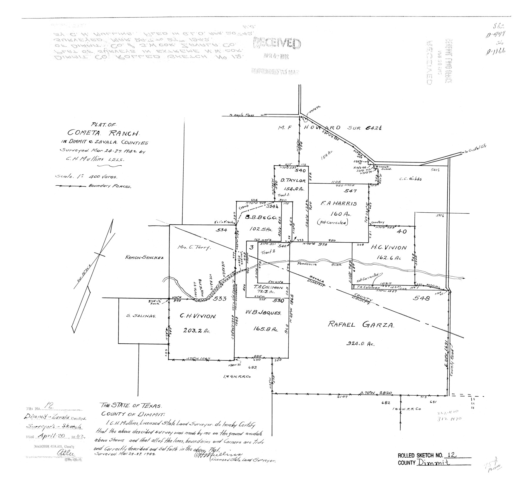
Dimmit County Rolled Sketch 12
Plat of Cometa Ranch in Dimmit & Zavala Counties
-
Map/Doc
5721
-
Collection
General Map Collection
-
Object Dates
1942/3/27 (Creation Date)
1942/4/20 (File Date)
-
People and Organizations
C.H. Mullins (Surveyor/Engineer)
-
Counties
Dimmit Zavala
-
Subjects
Surveying Rolled Sketch
-
Height x Width
19.8 x 21.5 inches
50.3 x 54.6 cm
-
Scale
1" = 400 varas
Part of: General Map Collection
Ochiltree County Boundary File 5b

Print $4.00
- Digital $50.00
Ochiltree County Boundary File 5b
Size 13.7 x 8.7 inches
Map/Doc 57697
Reeves County Working Sketch 11

Print $20.00
- Digital $50.00
Reeves County Working Sketch 11
1957
Size 27.7 x 36.9 inches
Map/Doc 63454
San Jacinto County Sketch File 17

Print $40.00
San Jacinto County Sketch File 17
1934
Size 60.1 x 26.3 inches
Map/Doc 10598
Randall County

Print $20.00
- Digital $50.00
Randall County
1958
Size 43.0 x 35.1 inches
Map/Doc 73269
Parker County Sketch File 15A

Print $20.00
- Digital $50.00
Parker County Sketch File 15A
1875
Size 28.5 x 13.6 inches
Map/Doc 12144
Limestone County Working Sketch 16

Print $40.00
- Digital $50.00
Limestone County Working Sketch 16
1951
Size 55.7 x 27.8 inches
Map/Doc 70566
Hardin County Rolled Sketch 20

Print $20.00
- Digital $50.00
Hardin County Rolled Sketch 20
1960
Size 27.7 x 35.9 inches
Map/Doc 6089
Hood County Rolled Sketch 7

Print $20.00
- Digital $50.00
Hood County Rolled Sketch 7
2009
Size 19.1 x 24.5 inches
Map/Doc 89062
Flight Mission No. DQO-12K, Frame 40, Galveston County

Print $20.00
- Digital $50.00
Flight Mission No. DQO-12K, Frame 40, Galveston County
1952
Size 18.6 x 22.3 inches
Map/Doc 85230
Current Miscellaneous File 63

Print $6.00
- Digital $50.00
Current Miscellaneous File 63
1957
Size 14.1 x 8.8 inches
Map/Doc 74100
Shackelford County Boundary File 4

Print $2.00
- Digital $50.00
Shackelford County Boundary File 4
Size 6.6 x 8.8 inches
Map/Doc 58660
Stephens County Working Sketch 32

Print $20.00
- Digital $50.00
Stephens County Working Sketch 32
1978
Size 30.9 x 28.7 inches
Map/Doc 63975
You may also like
Crockett County Rolled Sketch 63

Print $20.00
- Digital $50.00
Crockett County Rolled Sketch 63
1947
Size 18.9 x 30.8 inches
Map/Doc 5606
DeWitt County Working Sketch 7

Print $20.00
- Digital $50.00
DeWitt County Working Sketch 7
1977
Size 19.0 x 21.2 inches
Map/Doc 68597
Duval County Working Sketch 41

Print $20.00
- Digital $50.00
Duval County Working Sketch 41
1963
Size 24.1 x 22.9 inches
Map/Doc 68765
El Paso County Rolled Sketch 52

Print $20.00
- Digital $50.00
El Paso County Rolled Sketch 52
1929
Size 18.4 x 24.4 inches
Map/Doc 5845

Flight Mission No. CRE-2R, Frame 154, Jackson County

Print $20.00
- Digital $50.00
Flight Mission No. CRE-2R, Frame 154, Jackson County
1956
Size 16.1 x 16.0 inches
Map/Doc 85365
Map of Palo Pinto County, east of the Brazos River, Robertson - west of it, Milam Land District

Print $20.00
- Digital $50.00
Map of Palo Pinto County, east of the Brazos River, Robertson - west of it, Milam Land District
1859
Size 27.4 x 22.3 inches
Map/Doc 3935
New Map of State of Texas

Print $20.00
- Digital $50.00
New Map of State of Texas
1881
Size 21.4 x 27.6 inches
Map/Doc 460
The Inca, Machu Picchu Salutes the Sun

The Inca, Machu Picchu Salutes the Sun
Size 20.4 x 31.3 inches
Map/Doc 95935
Falls County Sketch File 19

Print $4.00
- Digital $50.00
Falls County Sketch File 19
1871
Size 12.8 x 8.4 inches
Map/Doc 22386
Travis County Rolled Sketch 29

Print $20.00
- Digital $50.00
Travis County Rolled Sketch 29
1946
Size 25.1 x 37.8 inches
Map/Doc 8031
Lamb County Sketch File 11

Print $6.00
- Digital $50.00
Lamb County Sketch File 11
1913
Size 11.5 x 8.8 inches
Map/Doc 29360