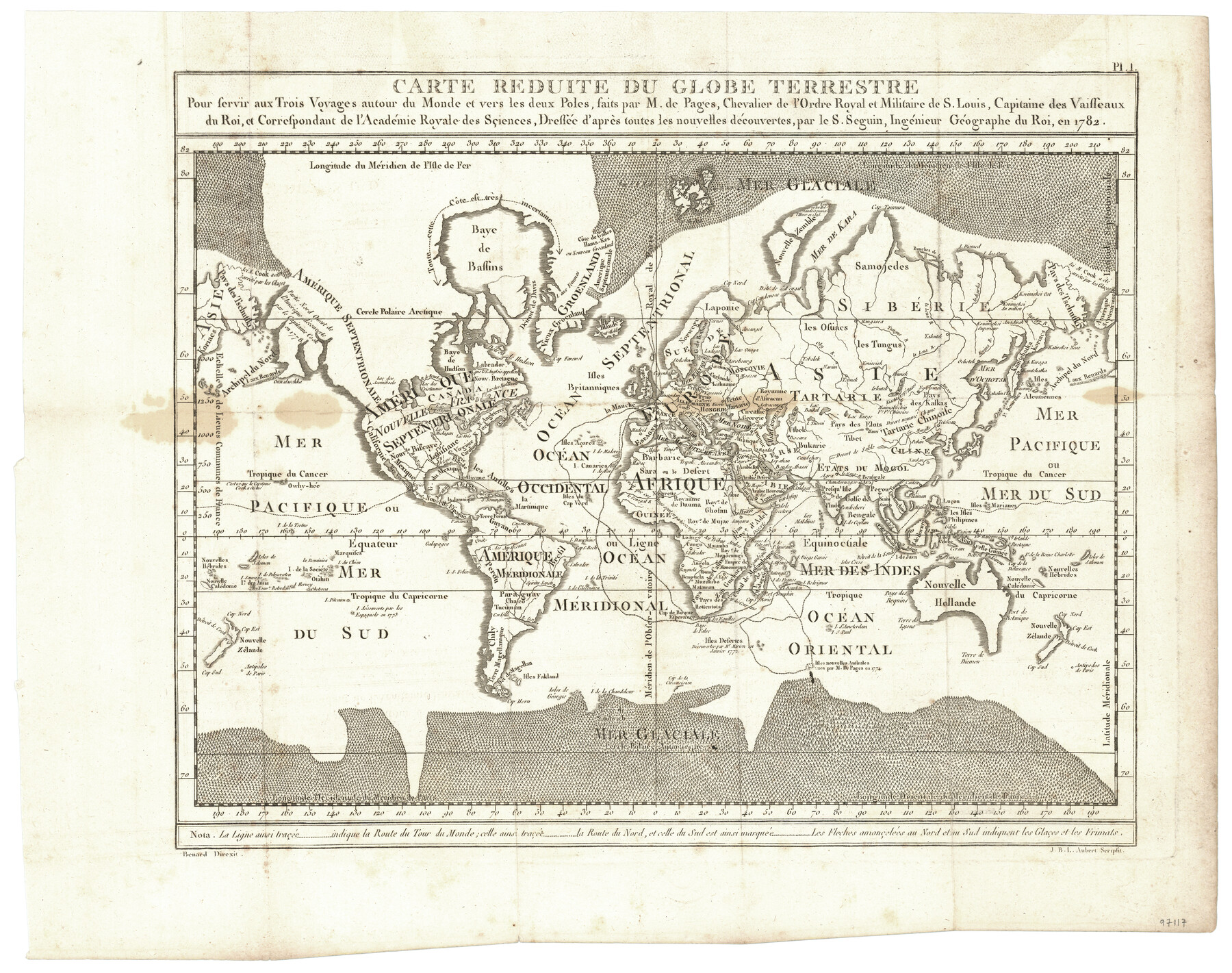
Carte Reduite du Globe Terrestre
Pour servir aux Trois Voyages autour du Monde et vers les deux Poles, faits par M. de Pages, Chevalier de l'Ordre Royal et Militaire de S. Louis, Capitaine des Vaisseaux du Roi, et Correspondant de l'Académie Royale des Sçiences, Dressée d'après toutes les nouvelles découvertes, par le S. Seguin, Ingénieur Géographe du Roi, en 1782
-
Map/Doc
97117
-
Collection
General Map Collection
-
Object Dates
1782 (Creation Date)
-
Subjects
World
-
Height x Width
13.5 x 17.1 inches
34.3 x 43.4 cm
-
Comments
Map appears in "Voyages Autour du Monde, et vers les deux poles par terre et par mer - Tome Second" (97086)
Related maps
Carte d'une partie de l'Amérique Séptentrionale, qui contient partie de la Nle. Espagne, et de la Louisiane

Print $20.00
- Digital $50.00
Carte d'une partie de l'Amérique Séptentrionale, qui contient partie de la Nle. Espagne, et de la Louisiane
1782
Size 14.1 x 18.5 inches
Map/Doc 94096
Voyages Autour du Monde, et vers les deux poles par terre et par mer - Tome Second

Voyages Autour du Monde, et vers les deux poles par terre et par mer - Tome Second
1782
Map/Doc 97086
Part of: General Map Collection
Revised Map of West Half of Sabine Lake, Jefferson & Orange Cos., showing subdivision for mineral development

Print $40.00
- Digital $50.00
Revised Map of West Half of Sabine Lake, Jefferson & Orange Cos., showing subdivision for mineral development
1957
Size 58.9 x 42.0 inches
Map/Doc 2898
Delta County Sketch File 2

Print $4.00
- Digital $50.00
Delta County Sketch File 2
1871
Size 8.4 x 13.2 inches
Map/Doc 20670
Bosque County Working Sketch 17

Print $20.00
- Digital $50.00
Bosque County Working Sketch 17
1975
Size 18.3 x 21.1 inches
Map/Doc 67450
Crosby County Boundary File 3

Print $2.00
- Digital $50.00
Crosby County Boundary File 3
Size 11.2 x 8.7 inches
Map/Doc 52002
Chambers County Sketch File 53

Print $12.00
- Digital $50.00
Chambers County Sketch File 53
1952
Size 14.3 x 8.9 inches
Map/Doc 18087
Mason County Boundary File 6

Print $28.00
- Digital $50.00
Mason County Boundary File 6
Size 14.3 x 8.9 inches
Map/Doc 56874

Young County Rolled Sketch 19

Print $20.00
- Digital $50.00
Young County Rolled Sketch 19
2021
Size 24.3 x 30.4 inches
Map/Doc 97023
Jackson County Rolled Sketch 3A

Print $20.00
- Digital $50.00
Jackson County Rolled Sketch 3A
1913
Size 23.2 x 22.6 inches
Map/Doc 6337
Old Miscellaneous File 17

Print $24.00
- Digital $50.00
Old Miscellaneous File 17
1908
Size 14.2 x 8.6 inches
Map/Doc 75485
Angelina County Sketch File 19

Print $22.00
- Digital $50.00
Angelina County Sketch File 19
1876
Size 8.2 x 12.6 inches
Map/Doc 13036
Crockett County Rolled Sketch 29

Print $20.00
- Digital $50.00
Crockett County Rolled Sketch 29
1927
Size 22.0 x 36.9 inches
Map/Doc 5781
You may also like
Texas, Aransas Bay, Copano Bay and St. Charles Bay

Print $40.00
- Digital $50.00
Texas, Aransas Bay, Copano Bay and St. Charles Bay
1934
Size 34.0 x 48.6 inches
Map/Doc 73434
Cass County Working Sketch 23

Print $40.00
- Digital $50.00
Cass County Working Sketch 23
1966
Size 56.8 x 37.1 inches
Map/Doc 67926
Brazoria County NRC Article 33.136 Sketch 17

Print $88.00
- Digital $50.00
Brazoria County NRC Article 33.136 Sketch 17
2015
Size 22.0 x 34.0 inches
Map/Doc 95020
Grayson County Working Sketch 25

Print $20.00
- Digital $50.00
Grayson County Working Sketch 25
1979
Size 34.8 x 35.0 inches
Map/Doc 63264
Texas Intracoastal Waterway - Laguna Madre - Rincon de San Jose to Chubby Island

Print $20.00
- Digital $50.00
Texas Intracoastal Waterway - Laguna Madre - Rincon de San Jose to Chubby Island
1957
Size 39.2 x 27.1 inches
Map/Doc 73512
Henderson County Boundary File 3c

Print $40.00
- Digital $50.00
Henderson County Boundary File 3c
Size 22.5 x 80.6 inches
Map/Doc 54707
Foard County Sketch File X1

Print $40.00
- Digital $50.00
Foard County Sketch File X1
Size 17.6 x 14.2 inches
Map/Doc 22800
County and Railroad Map of Texas

Print $20.00
- Digital $50.00
County and Railroad Map of Texas
1871
Size 16.7 x 15.5 inches
Map/Doc 95752
Ward County Rolled Sketch 10

Print $20.00
- Digital $50.00
Ward County Rolled Sketch 10
1936
Size 24.4 x 35.7 inches
Map/Doc 8155
Dickens County Sketch File 19

Print $4.00
- Digital $50.00
Dickens County Sketch File 19
1910
Size 8.4 x 7.5 inches
Map/Doc 20982
Terrell County Sketch File 12

Print $4.00
- Digital $50.00
Terrell County Sketch File 12
1903
Size 5.7 x 8.5 inches
Map/Doc 37922
Fisher County Working Sketch 4

Print $20.00
- Digital $50.00
Fisher County Working Sketch 4
1926
Size 24.4 x 17.2 inches
Map/Doc 69138