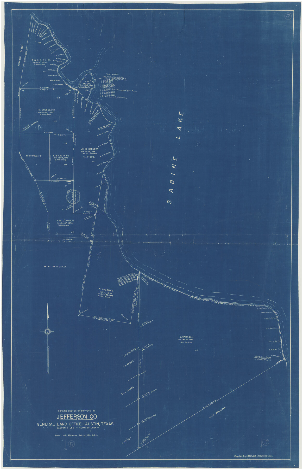
Jefferson County Working Sketch 17
-
Map/Doc
66560
-
Collection
General Map Collection
-
Object Dates
2/11/1954 (Creation Date)
-
People and Organizations
Otto G. Kurio (Draftsman)
-
Counties
Jefferson
-
Subjects
Surveying Working Sketch
-
Height x Width
47.1 x 30.3 inches
119.6 x 77.0 cm
-
Scale
1" = 400 varas
Part of: General Map Collection
Brazos Santiago

Print $20.00
- Digital $50.00
Brazos Santiago
1884
Size 24.4 x 18.2 inches
Map/Doc 73030
Travis County Sketch File 75

Print $2.00
- Digital $50.00
Travis County Sketch File 75
1992
Size 11.2 x 8.9 inches
Map/Doc 38473
Garza County Working Sketch 5

Print $20.00
- Digital $50.00
Garza County Working Sketch 5
1943
Size 19.4 x 34.7 inches
Map/Doc 63152
Jasper County Working Sketch 10

Print $20.00
- Digital $50.00
Jasper County Working Sketch 10
1917
Size 17.4 x 22.7 inches
Map/Doc 66472
Garza County Sketch File 31

Print $10.00
- Digital $50.00
Garza County Sketch File 31
1914
Size 13.4 x 8.9 inches
Map/Doc 24104
Live Oak County Working Sketch 4

Print $20.00
- Digital $50.00
Live Oak County Working Sketch 4
1914
Size 16.8 x 14.0 inches
Map/Doc 70589
Van Zandt County Sketch File A45

Print $40.00
- Digital $50.00
Van Zandt County Sketch File A45
Size 14.2 x 13.7 inches
Map/Doc 39501
Childress County Sketch File 12

Print $22.00
- Digital $50.00
Childress County Sketch File 12
Size 13.3 x 8.7 inches
Map/Doc 18255
Trinity River, Cooks Ferry Sheet

Print $40.00
- Digital $50.00
Trinity River, Cooks Ferry Sheet
1926
Size 36.5 x 56.2 inches
Map/Doc 65215
Rockwall County Boundary File 9a

Print $4.00
- Digital $50.00
Rockwall County Boundary File 9a
Size 14.0 x 8.8 inches
Map/Doc 58437
Denton County Sketch File 18

Print $4.00
- Digital $50.00
Denton County Sketch File 18
1856
Size 7.9 x 7.3 inches
Map/Doc 20731
Terry County Working Sketch 3

Print $40.00
- Digital $50.00
Terry County Working Sketch 3
1953
Size 125.9 x 28.4 inches
Map/Doc 62108
You may also like
El Paso County Boundary File 17

Print $8.00
- Digital $50.00
El Paso County Boundary File 17
Size 13.4 x 8.4 inches
Map/Doc 53192
Map of Webb County

Print $20.00
- Digital $50.00
Map of Webb County
1879
Size 36.8 x 25.4 inches
Map/Doc 4131

Williamson County Rolled Sketch 9

Print $20.00
- Digital $50.00
Williamson County Rolled Sketch 9
Size 25.3 x 32.8 inches
Map/Doc 8266
Cass County Rolled Sketch BRR

Print $40.00
- Digital $50.00
Cass County Rolled Sketch BRR
1936
Size 67.3 x 28.0 inches
Map/Doc 8581
Hardeman County Rolled Sketch 17

Print $40.00
- Digital $50.00
Hardeman County Rolled Sketch 17
1888
Size 57.9 x 31.1 inches
Map/Doc 9100
Pecos County Rolled Sketch 70A

Print $20.00
- Digital $50.00
Pecos County Rolled Sketch 70A
1929
Size 46.7 x 20.8 inches
Map/Doc 9709
Trinity River, Five Mile Creek Sheet

Print $20.00
- Digital $50.00
Trinity River, Five Mile Creek Sheet
1923
Size 20.0 x 40.4 inches
Map/Doc 65197
[Sketch for Mineral Application 24072, San Jacinto River]
![65595, [Sketch for Mineral Application 24072, San Jacinto River], General Map Collection](https://historictexasmaps.com/wmedia_w700/maps/65595.tif.jpg)
Print $20.00
- Digital $50.00
[Sketch for Mineral Application 24072, San Jacinto River]
1929
Size 15.0 x 17.5 inches
Map/Doc 65595
[Blocks 5-T, R-2, M-24, and M-23]
![91149, [Blocks 5-T, R-2, M-24, and M-23], Twichell Survey Records](https://historictexasmaps.com/wmedia_w700/maps/91149-1.tif.jpg)
Print $20.00
- Digital $50.00
[Blocks 5-T, R-2, M-24, and M-23]
Size 15.5 x 19.7 inches
Map/Doc 91149
Red River County Working Sketch 80

Print $20.00
- Digital $50.00
Red River County Working Sketch 80
1982
Size 24.1 x 29.3 inches
Map/Doc 72063
General Highway Map, Tom Green County, Texas

Print $20.00
General Highway Map, Tom Green County, Texas
1940
Size 24.9 x 18.3 inches
Map/Doc 79259