Childress County Sketch File 12
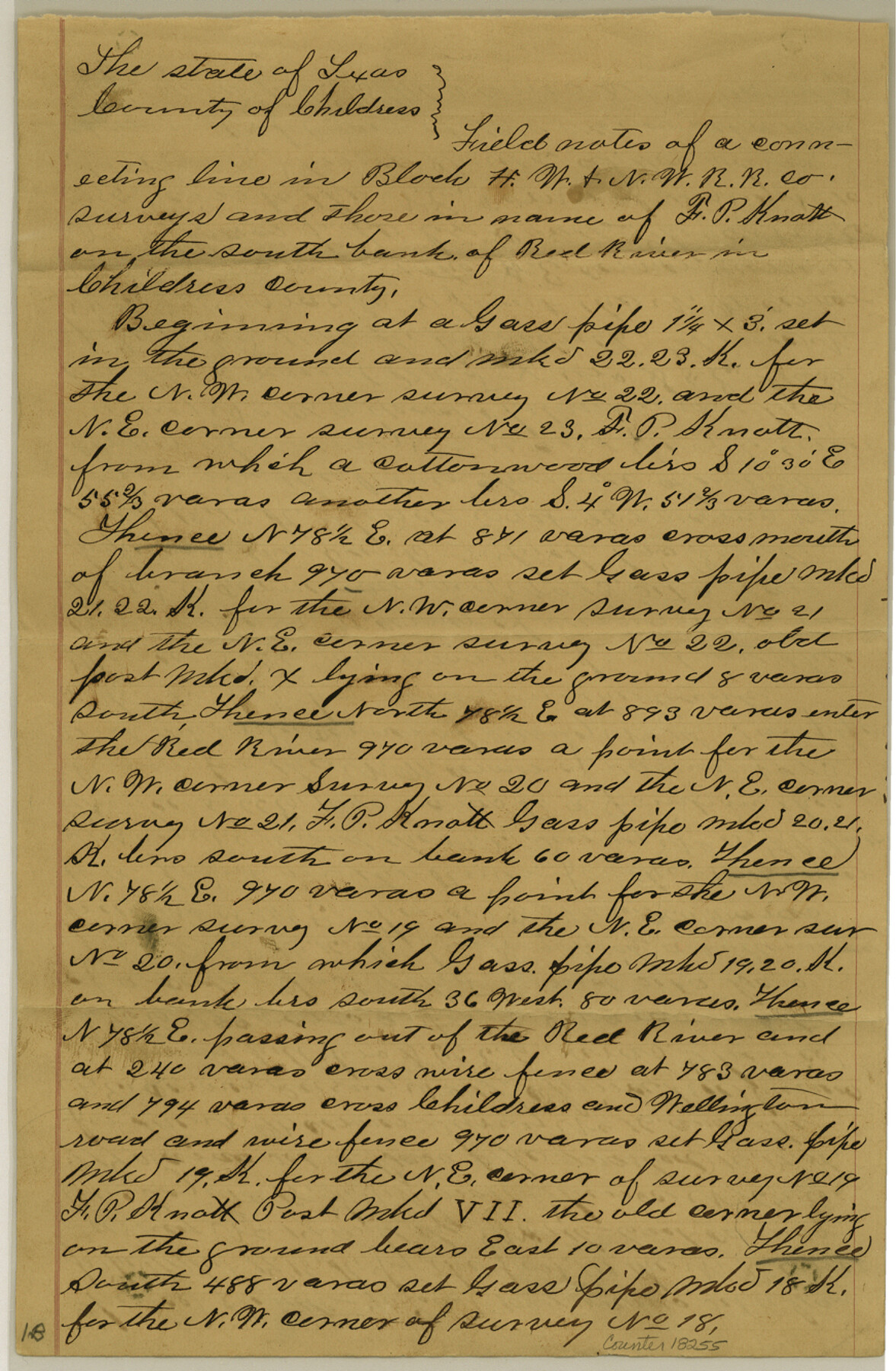
[Field notes of a connecting line in Block H, W. & N. W. R.R. Co. and those in the name of F.P. Knott on the south bank of the Red River]
-
Map/Doc
18255
-
Collection
General Map Collection
-
Object Dates
1892/5/4 (Survey Date)
1892/10/29 (File Date)
-
People and Organizations
T.L. Crews (Surveyor/Engineer)
L.D. Byres (Chainman/Field Personnel)
M.G. Bryant (Chainman/Field Personnel)
-
Counties
Childress
-
Subjects
Surveying Sketch File
-
Height x Width
13.3 x 8.7 inches
33.8 x 22.1 cm
-
Medium
paper, manuscript
-
Features
Red River
Childress and Wellington Road
Childress Road
Wellington Road
Grassy Creek
Baylor Creek
Rustler Creek
Part of: General Map Collection
Reeves County Rolled Sketch 21

Print $20.00
- Digital $50.00
Reeves County Rolled Sketch 21
1978
Size 27.6 x 27.6 inches
Map/Doc 7489
Culberson County Working Sketch 5

Print $20.00
- Digital $50.00
Culberson County Working Sketch 5
1906
Size 22.2 x 17.2 inches
Map/Doc 68457
Dickens County Sketch File D

Print $20.00
- Digital $50.00
Dickens County Sketch File D
1883
Size 15.7 x 14.8 inches
Map/Doc 11330
Map of Surveys Made for the T&PRRCo in Tom Green & Martin Counties, Blocks 40, 41, 42, 43, 44, 45 & 46, Reserve West of the Colorado

Print $20.00
- Digital $50.00
Map of Surveys Made for the T&PRRCo in Tom Green & Martin Counties, Blocks 40, 41, 42, 43, 44, 45 & 46, Reserve West of the Colorado
1876
Size 42.3 x 46.0 inches
Map/Doc 2227
Lamb County Boundary File 1a

Print $24.00
- Digital $50.00
Lamb County Boundary File 1a
Size 11.3 x 8.7 inches
Map/Doc 56032
Hutchinson County Rolled Sketch 44-17

Print $20.00
- Digital $50.00
Hutchinson County Rolled Sketch 44-17
2002
Size 24.0 x 36.0 inches
Map/Doc 77553
Palo Pinto County Working Sketch 11

Print $20.00
- Digital $50.00
Palo Pinto County Working Sketch 11
1942
Size 21.2 x 22.1 inches
Map/Doc 71394
Stonewall County Sketch File 24

Print $6.00
- Digital $50.00
Stonewall County Sketch File 24
1951
Size 24.8 x 35.2 inches
Map/Doc 12369
Coleman County Working Sketch 11

Print $20.00
- Digital $50.00
Coleman County Working Sketch 11
1950
Size 24.2 x 18.2 inches
Map/Doc 68077
Terrell County Sketch File 33

Print $20.00
- Digital $50.00
Terrell County Sketch File 33
1924
Size 18.2 x 27.6 inches
Map/Doc 12427
Menard County Boundary File 2b

Print $6.00
- Digital $50.00
Menard County Boundary File 2b
Size 13.3 x 8.2 inches
Map/Doc 57069
Travis County Sketch File 19-28

Print $12.00
- Digital $50.00
Travis County Sketch File 19-28
1873
Size 8.6 x 7.7 inches
Map/Doc 38317
You may also like
Flight Mission No. DQO-1K, Frame 117, Galveston County

Print $20.00
- Digital $50.00
Flight Mission No. DQO-1K, Frame 117, Galveston County
1952
Size 18.9 x 22.5 inches
Map/Doc 84995
Jim Hogg County Working Sketch 12

Print $20.00
- Digital $50.00
Jim Hogg County Working Sketch 12
1984
Size 17.4 x 15.2 inches
Map/Doc 66598
Midland County Working Sketch 24

Print $40.00
- Digital $50.00
Midland County Working Sketch 24
1957
Size 42.9 x 80.9 inches
Map/Doc 71005
Denton County Sketch File 14

Print $10.00
- Digital $50.00
Denton County Sketch File 14
1855
Size 8.6 x 10.0 inches
Map/Doc 20719
Bandera County Working Sketch 46

Print $20.00
- Digital $50.00
Bandera County Working Sketch 46
1981
Size 28.0 x 37.4 inches
Map/Doc 67642
Flight Mission No. DQN-2K, Frame 188, Calhoun County

Print $20.00
- Digital $50.00
Flight Mission No. DQN-2K, Frame 188, Calhoun County
1953
Size 18.6 x 22.3 inches
Map/Doc 84329
[Surveying Sketch of John Poitevent Block 1, Railroad Lands, et al in Knox County, Texas]
![414, [Surveying Sketch of John Poitevent Block 1, Railroad Lands, et al in Knox County, Texas], Maddox Collection](https://historictexasmaps.com/wmedia_w700/maps/0414.tif.jpg)
Print $3.00
- Digital $50.00
[Surveying Sketch of John Poitevent Block 1, Railroad Lands, et al in Knox County, Texas]
Size 11.9 x 14.2 inches
Map/Doc 414
Edwards County Working Sketch 120

Print $40.00
- Digital $50.00
Edwards County Working Sketch 120
1975
Size 25.0 x 48.9 inches
Map/Doc 68996
[Part of Eastern Texas RR. Co. Block 1]
![91921, [Part of Eastern Texas RR. Co. Block 1], Twichell Survey Records](https://historictexasmaps.com/wmedia_w700/maps/91921-1.tif.jpg)
Print $20.00
- Digital $50.00
[Part of Eastern Texas RR. Co. Block 1]
Size 23.9 x 43.1 inches
Map/Doc 91921
Amistad International Reservoir on Rio Grande 68

Print $20.00
- Digital $50.00
Amistad International Reservoir on Rio Grande 68
1949
Size 28.4 x 39.4 inches
Map/Doc 73353

Burnet County Sketch File 42

Print $28.00
- Digital $50.00
Burnet County Sketch File 42
1950
Size 9.9 x 8.8 inches
Map/Doc 16760