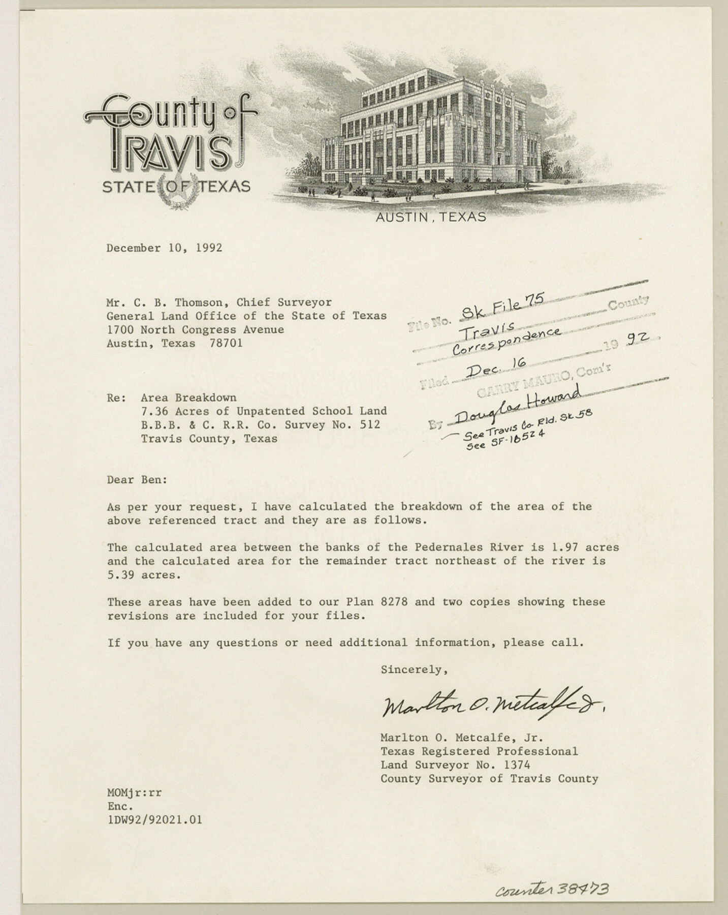
Travis County Sketch File 75
[Correspondence regarding area breakdown of 7.36 acres of unpatented school land, B. B. B. & C. RR. Co. survey 512]
-
Map/Doc
38473
-
Collection
General Map Collection
-
Object Dates
12/10/1992 (Creation Date)
12/16/1992 (File Date)
-
People and Organizations
Marlton O. Metcalfe, Jr. (Surveyor/Engineer)
-
Counties
Travis
-
Subjects
Surveying Sketch File
-
Height x Width
11.2 x 8.9 inches
28.5 x 22.6 cm
-
Medium
paper, print
-
Comments
See SF-16524 and Travis County Rolled Sketch 58 (8049) for sketch.
-
Features
Pedernales River
Related maps
Travis County Rolled Sketch 58

Print $20.00
- Digital $50.00
Travis County Rolled Sketch 58
Size 37.4 x 25.5 inches
Map/Doc 8049
Part of: General Map Collection
Val Verde County Working Sketch 117

Print $20.00
- Digital $50.00
Val Verde County Working Sketch 117
1993
Size 24.7 x 29.8 inches
Map/Doc 82846
Nueces County Aerial Photograph Index Sheet 1

Print $20.00
- Digital $50.00
Nueces County Aerial Photograph Index Sheet 1
1956
Size 23.4 x 19.6 inches
Map/Doc 83736
Map of Hopkins County

Print $20.00
- Digital $50.00
Map of Hopkins County
1872
Size 17.8 x 18.4 inches
Map/Doc 4566
Liberty County Sketch File 27

Print $5.00
- Digital $50.00
Liberty County Sketch File 27
Size 11.5 x 9.3 inches
Map/Doc 29948
Old Miscellaneous File 22

Print $18.00
- Digital $50.00
Old Miscellaneous File 22
1915
Size 14.2 x 8.7 inches
Map/Doc 75591
Starr County Sketch File 44

Print $8.00
- Digital $50.00
Starr County Sketch File 44
1944
Size 14.1 x 8.8 inches
Map/Doc 36995
Tarrant County Working Sketch 18

Print $20.00
- Digital $50.00
Tarrant County Working Sketch 18
1996
Size 20.4 x 18.5 inches
Map/Doc 62435
Hudspeth County Sketch File 12

Print $10.00
- Digital $50.00
Hudspeth County Sketch File 12
1901
Size 14.2 x 8.7 inches
Map/Doc 26924
Map of Nacogdoches County

Print $20.00
- Digital $50.00
Map of Nacogdoches County
1881
Size 24.1 x 21.2 inches
Map/Doc 4603
Hall County Sketch File 9a

Print $4.00
- Digital $50.00
Hall County Sketch File 9a
1884
Size 12.7 x 8.4 inches
Map/Doc 24830
Index Map No. 1 - Rio Bravo del Norte section of boundary between the United States & Mexico; agreed upon by the Joint Commission under the Treaty of Guadalupe Hidalgo

Print $20.00
- Digital $50.00
Index Map No. 1 - Rio Bravo del Norte section of boundary between the United States & Mexico; agreed upon by the Joint Commission under the Treaty of Guadalupe Hidalgo
1852
Size 18.5 x 27.4 inches
Map/Doc 72859
Crockett County Rolled Sketch 3

Print $20.00
- Digital $50.00
Crockett County Rolled Sketch 3
1886
Size 18.1 x 22.9 inches
Map/Doc 5579
You may also like
Val Verde County Sketch File DD and DD1

Print $64.00
- Digital $50.00
Val Verde County Sketch File DD and DD1
1889
Size 8.9 x 7.9 inches
Map/Doc 39067
Crane County Working Sketch 8

Print $20.00
- Digital $50.00
Crane County Working Sketch 8
1929
Size 33.2 x 28.4 inches
Map/Doc 68285
Val Verde County Working Sketch 29

Print $20.00
- Digital $50.00
Val Verde County Working Sketch 29
1937
Size 20.2 x 41.6 inches
Map/Doc 72164
Leon County Sketch File 8

Print $4.00
- Digital $50.00
Leon County Sketch File 8
1862
Size 12.8 x 8.3 inches
Map/Doc 29724
Starr County Sketch File D

Print $8.00
- Digital $50.00
Starr County Sketch File D
1892
Size 14.2 x 8.7 inches
Map/Doc 36915
The Republic County of Travis. Spring 1842

Print $20.00
The Republic County of Travis. Spring 1842
2020
Size 20.8 x 21.6 inches
Map/Doc 96292
Burleson County Working Sketch 10

Print $3.00
- Digital $50.00
Burleson County Working Sketch 10
1980
Size 15.1 x 9.7 inches
Map/Doc 67729
San Jacinto County Working Sketch 9

Print $20.00
- Digital $50.00
San Jacinto County Working Sketch 9
1935
Size 36.1 x 42.1 inches
Map/Doc 63722
[Sketch for Mineral Application 16696-16697, Pecos River]
![65613, [Sketch for Mineral Application 16696-16697, Pecos River], General Map Collection](https://historictexasmaps.com/wmedia_w700/maps/65613-1.tif.jpg)
Print $40.00
- Digital $50.00
[Sketch for Mineral Application 16696-16697, Pecos River]
Size 36.7 x 68.3 inches
Map/Doc 65613
Flight Mission No. DIX-7P, Frame 22, Aransas County

Print $20.00
- Digital $50.00
Flight Mission No. DIX-7P, Frame 22, Aransas County
1956
Size 18.7 x 22.5 inches
Map/Doc 83874
![92508, [Block A31], Twichell Survey Records](https://historictexasmaps.com/wmedia_w700/maps/92508-1.tif.jpg)
Washington County Sketch File 2

Print $4.00
- Digital $50.00
Washington County Sketch File 2
1855
Size 8.3 x 12.5 inches
Map/Doc 39646