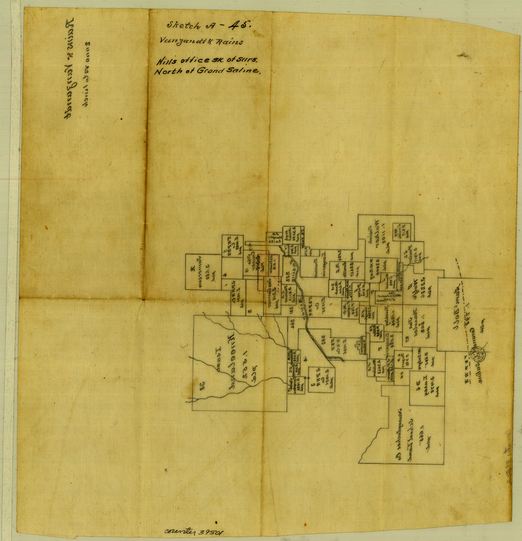
Van Zandt County Sketch File A45
[Office sketch of surveys north of Grand Saline in the northeast part of the county]
-
Map/Doc
39501
-
Collection
General Map Collection
-
People and Organizations
C.M. Hill (Draftsman)
-
Counties
Van Zandt Rains
-
Subjects
Surveying Sketch File
-
Height x Width
14.2 x 13.7 inches
36.1 x 34.8 cm
-
Medium
paper, manuscript
-
Features
Grande Saline Lake
Sabine River
T&P
Part of: General Map Collection
Atlantic Coast to the Rocky Mountains

Atlantic Coast to the Rocky Mountains
1956
Size 42.3 x 29.5 inches
Map/Doc 94410
Flight Mission No. BRE-4P, Frame 168, Nueces County

Print $20.00
- Digital $50.00
Flight Mission No. BRE-4P, Frame 168, Nueces County
1956
Size 18.7 x 22.6 inches
Map/Doc 86831
Colorado River, Wharton Sheet

Print $6.00
- Digital $50.00
Colorado River, Wharton Sheet
1941
Size 27.3 x 35.7 inches
Map/Doc 65314
Shackelford County Rolled Sketch 2

Print $40.00
- Digital $50.00
Shackelford County Rolled Sketch 2
Size 18.9 x 51.9 inches
Map/Doc 75935
Haskell County Rolled Sketch 15A

Print $3.00
- Digital $50.00
Haskell County Rolled Sketch 15A
1991
Size 11.3 x 17.1 inches
Map/Doc 6174
Right of Way & Track Map, St. Louis, Brownsville & Mexico Ry. operated by St. Louis, Brownsville & Mexico Ry. Co.

Print $40.00
- Digital $50.00
Right of Way & Track Map, St. Louis, Brownsville & Mexico Ry. operated by St. Louis, Brownsville & Mexico Ry. Co.
1919
Size 25.5 x 57.3 inches
Map/Doc 64622
Flight Mission No. BRA-7M, Frame 20, Jefferson County

Print $20.00
- Digital $50.00
Flight Mission No. BRA-7M, Frame 20, Jefferson County
1953
Size 18.6 x 22.2 inches
Map/Doc 85471
Llano County Sketch File 20

Print $4.00
- Digital $50.00
Llano County Sketch File 20
1873
Size 12.6 x 8.2 inches
Map/Doc 30405
Comanche County Working Sketch 24

Print $20.00
- Digital $50.00
Comanche County Working Sketch 24
1975
Size 29.8 x 33.4 inches
Map/Doc 68158
Flight Mission No. BRA-7M, Frame 77, Jefferson County

Print $20.00
- Digital $50.00
Flight Mission No. BRA-7M, Frame 77, Jefferson County
1953
Size 16.0 x 16.0 inches
Map/Doc 85499
Reeves County Working Sketch 55

Print $20.00
- Digital $50.00
Reeves County Working Sketch 55
1978
Size 36.1 x 34.7 inches
Map/Doc 63498
Hutchinson County Sketch File 1

Print $22.00
- Digital $50.00
Hutchinson County Sketch File 1
Size 8.9 x 7.8 inches
Map/Doc 27172
You may also like
Map of Freeport, Brazoria County, Texas

Print $20.00
- Digital $50.00
Map of Freeport, Brazoria County, Texas
Size 27.0 x 39.1 inches
Map/Doc 7689
Map of the City of Aransas Pass

Print $20.00
- Digital $50.00
Map of the City of Aransas Pass
1905
Size 28.3 x 21.4 inches
Map/Doc 97266

The MKT - Texas Empire of the South

Print $20.00
- Digital $50.00
The MKT - Texas Empire of the South
1905
Size 18.5 x 40.6 inches
Map/Doc 97035
Map of the Rio Grande & Eagle Pass Ry. from Sections 14-20 Inclusive, Webb County

Print $40.00
- Digital $50.00
Map of the Rio Grande & Eagle Pass Ry. from Sections 14-20 Inclusive, Webb County
1909
Size 25.3 x 55.6 inches
Map/Doc 64657


Dimmit County Working Sketch 37

Print $20.00
- Digital $50.00
Dimmit County Working Sketch 37
1962
Size 28.9 x 25.6 inches
Map/Doc 68698
Flight Mission No. CUG-3P, Frame 93, Kleberg County

Print $20.00
- Digital $50.00
Flight Mission No. CUG-3P, Frame 93, Kleberg County
1956
Size 18.5 x 22.2 inches
Map/Doc 86263
El Paso County Rolled Sketch 31

Print $20.00
- Digital $50.00
El Paso County Rolled Sketch 31
1908
Size 39.9 x 32.0 inches
Map/Doc 8858
Map of the Missouri, Kansas, & Texas Railway and Connecting Lines

Print $20.00
- Digital $50.00
Map of the Missouri, Kansas, & Texas Railway and Connecting Lines
Size 11.2 x 17.2 inches
Map/Doc 96599
Crosby County Sketch File 19

Print $6.00
- Digital $50.00
Crosby County Sketch File 19
1910
Size 8.2 x 8.1 inches
Map/Doc 20084